Maps of Scandinavia

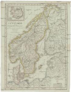
Schweden Daenemarck u. Norwegen
Dánsko Mollo, Tranquillo Tranquillo Mollo
Schweden, Norwegen, Daenemark.
1 : 4000000 Ziegler, J. M.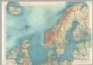
Northern Europe. Pergamon World Atlas.
1 : 5000000 Polish Army Topography Service
Kaart van Noorwegen, Denemarken, ijsland, Zweden, Finland, Engeland en de Noordzee / W. Seghers
1 : 4000000 Seghers, W. Antwerpen : Patria [etc.]
[Ethnographische Karte von Europa]
Zweiter Band, enthaltend in vier Abtheilungen die Vertheilung der Organismen: 5. Pflanzen-Geographie, 6. Thier-Geographie, 7. Anthropographie, 8. Ethnographie Humboldt, Alexander von Verlag von Justus Perthes
Karte von Europa, 1
4 Blätter : 53 x 70 cm Verlag der Königlich-Preussischen Academie-Kunst- und Buchhandlung
Dänemark, Island u Färöer, Schweden und Norwegen
Hand-Atlas über alle Theile der Erde nach dem neuesten Zustande und über das Weltgebäude Stieler, Adolf bei Justus Perthes
Charte von Schweden und Norwegen
1 : 3700000
Dänemark, Jsland u. Färöer, Schweden und Norwegen
Stieler's Hand-Atlas Stieler, Adolf bei Justus Perthes
Evropa, 1
1 Blatt : mehrfarbig ; 49 x 57 cm Homännische Erben
Länder der Nord- und Ostsee
1 : 10000000 Nordeuropa
Schonlandia XIII Nova Tabula [Karte], in: Claud. Ptolemaeus. Geographia lat. cum mappis [...], S. 389.
1 Karte aus Atlas Münster, Sebastian [und Ptolemaeus, Claudius]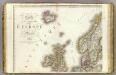
Europe 1.
1 : 3850000 Brue, Adrien Hubert, 1786-1832
Schonlandia XIII Nova Tabula [Karte], in: Geographia universalis vetus et nova complectens Claudii Ptolemaei Alexandrini enarrationis libros VIII, S. 335.
1 Karte aus Atlas Münster, Sebastian [und Ptolemaeus, Claudius]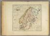
Sweden, Denmark, Norway and Finland.
1 : 6600000 Carey, Mathew
Spesielle kart 77: Bathymetrical and hypsometrical map of Norway
1 : 2400000 Kristiania Lithografiske Aktiebolag
Museumskart 178: Sjøkart over Norskehavet
1 : 1000000
Western part of the northern states including the British Islands Norway Denmark and part of Sweden
1 Blatt : 53 x 68 cm Sayer
Nordeuropa 1922
Nordeuropa Kunz, Andreas ; Treiling, Thomas
Statistikk kart 23: Les marchandises exportees
1 : 2400000
Spesielle kart 66-4: Kart udvisende de med bidrag af Statskassen understøttende Dampskibsrouter
1 : 2400000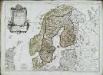
Les couronnes du Nord comprenant les royaumes de Suede Danemarck et Norwege
1 Karte : Kupferdruck ; 46 x 64 cm Janvier; Lattré; Choffard chés Lattré graveur rue Saint Jacques au coin de celle de la parcheminerie à la ville de Bordeaux
Statistikk kart 22: Tonnage de navires 1873
1 : 2400000
Spesielle kart 62: Pflanzengeographisce Karte über das Königreich Norwegen
1 : 2000000
Spesielle kart 66-5: Kart udvisende de med bidrag af Statskassen understøttende Dampskibsrouter
1 : 2400000
The countries of northern Europe

Sweden, Denmark, Norway and Finland.
1 : 6336000 Carey, Mathew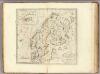
Sweden, Denmark, Norway and Finland.
1 : 8236800 Carey, Mathew
Sweden, Denmark, Norway and Finland.
1 : 8236800 Carey, Mathew