Maps of Norway
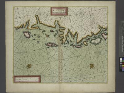
The Chart of FINMARCK from Sanien to North-Kyn or North point
from The sea-atlas : containing an hydrographical description of most of the sea-coasts of the known parts of the world.
Museumskart 178: Sjøkart over Norskehavet
1 : 1000000

Spesielle kart 77: Bathymetrical and hypsometrical map of Norway
1 : 2400000 Kristiania Lithografiske Aktiebolag

Statistikk 9- Norvege. Mouvement de la population
1 : 2400000
Spesielle kart 66-4: Kart udvisende de med bidrag af Statskassen understøttende Dampskibsrouter
1 : 2400000
Karte von dem Koenigreiche Daenemark
1 : 980000 Dánsko Reilly, Franz Johann Josef von Müller, Franz Franz Ioh. Ios. von Reilly
Karte von dem Koenigreiche Norwegen
1 : 1500000 Norsko Reilly, Franz Johann Josef von Stöber, Joseph Franz Ioh. Ios. von Reilly
Spesielle kart 72b: Kart over Valgmands- og Stortingsvalgene
1 : 2400000 K. Petersen Olaf Norli's forlag; Kristiania
Statistikk kart 12-a: Norvège. Division administrative
1 : 2400000
Ost-Europa In 6 Blattern, Enthaltend: Norwegen, Schweden, Russland, Kaukasien Und Die Turkei .
1 : 3700000 Petermann, A.
Spesielle kart 66-5: Kart udvisende de med bidrag af Statskassen understøttende Dampskibsrouter
1 : 2400000
Spesielle kart 130-2: Oversigt over tætbebyggelse, stà ̧rre industrielle bedrifter og vigtige gruber ...
1 : 2800000
Golfe de Botnie.
1 : 3700000 Vincent
Spesielle kart 66-6: Kart udvisende de med bidrag af Statskassen understøttende Dampskibsrouter
1 : 2400000
Statistikk kart 19- Fremstilling af Norges Agerbrug. Udsæden af Korn i Tønder pr. 1000 maal ager
1 : 2400000
Statistikk kart 22: Tonnage de navires 1873
1 : 2400000
Statistikk kart 21- Norvege. Pêches.
1 : 2400000
Statistikk 26-8c: Gjeder. Middeltal pr. Gaard
1 : 2400000
Spesielle kart 130-1: Folketæthed Efter Norges officielle statistik ...
1 : 2800000
Spesielle kart 66-7: Kart udvisende de med bidrag af Statskassen understøttende Dampskibsrouter
1 : 2400000
Sweden and Norway with Russian Finland.
1 : 3801600 Fullarton, A. & Co.
Statistikk kart 20- Fremstilling af den Norske Fædrift. Hesten. Dyrenes antal pr. 1000 Maal afhøstet areal
1 : 2400000
Spesielle kart 129-4: Bilag nr 3 til opmaalingens budgetforslag for 1915-1916
1 : 2800000
spesielle kart 129-2: Oversigtskart over Gradavdelingskarter og Rektangelkarter, bilag 2
1 : 2800000
Charte von Schweden u. Norwegen
1 : 5300000 Norsko Streit, Friedrich Wilhelm
Russia 1.
1 : 4435200 Letts, Son & Co.
Spesielle kart 62: Pflanzengeographisce Karte über das Königreich Norwegen
1 : 2000000