Maps of Arctic Ocean

Museumskart 175: Kystkart over Nord-Norge, Russland og Spitsbergen
1 : 500000 Theunis Jacobsz | Pieter Goos
Museumskart 150: Nieuwe zee-kaart van het noorder gedeelte van Europa
1 : 1000000 Johannes van Keulen
Carte mar.ne de Suede, Norwege, Nouv.le Zemble et de Spitsberge
1 Karte : Kupferdruck ; 42 x 48 cm Königliche Akademie der Wissenschaften
Pascaart Vande Zee-Custen van Finnmarcken, Laplant, Ruslant, Nova Zembla en Spitzsbergen [...] Tabula Hydrographica [...] [Karte], in: Novus atlas absolutissimus, Bd. 9, S. 160.
1 Karte aus Atlas Janssonius Offizin
Pascaart vande Zee-Custen Van Finmarcken, Laplant, Ruslant, Nova Zembla en Spitsbergen [...] [Karte], in: Het vijfde Deel Des Grooten Atlas : Vervatende De Water-Weereld, S. 119.
1 Karte aus Atlas Jansson, Jan Jansson, Jan
Nieuwe pascaart inhoudende 't noorder deel van Europa sijnde seer dienstigh voor de Groenlandse en Moskovise scheepvaart
1 : 3500000 nieuwelijkx opgestelt door G. v. Keulen t'Amsterdam : bij Johannes van Keulen, Zeekaard Verkooper en Graad-boog maker Aande Oost Zijde vande Nieuwen Brugh Inde Gekroonde Lootsman
Pascaart van de zee-custen van Ruslant, Laplant, Finmarcken, Spitsbergen en Nova-zemla
1 Karte : Kupferdruck ; 43 x 53 cm Doncker bÿ Hendrick Doncker inde Nieubrug steegh in't Stuurmans gereedtschap
Europe N.
1 : 4050000 Thomson, John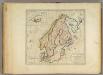
Sweden, Denmark, Norway and Finland.
1 : 6600000 Carey, Mathew
Museumskart 178: Sjøkart over Norskehavet
1 : 1000000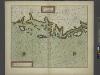
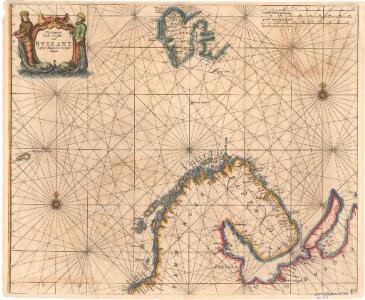
The Chart of FINMARCK from Sanien to North-Kyn or North point
from The sea-atlas : containing an hydrographical description of most of the sea-coasts of the known parts of the world.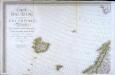
Carte d'Europe ou sont tracées les limites des empires, royaumes, et etats souverains, feuille 1
1 Blatt : 63 x 96 cm Semen etc
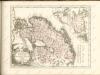
Finmarchiæ et Laplandiæ maritima
1 Karte : Kupferdruck ; 49 x 55 cm Renard Louis Renard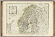
A new map of the Northern States containing the Kingdoms of Sweden, Denmark, and Norway.
1 : 4400000 Kitchin, Thomas

Russia 1.
1 : 4435200 Letts, Son & Co.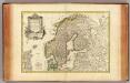
Suede, Danemarck et Norwege.
1 : 6900000 Janvier, Jean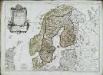
Les couronnes du Nord comprenant les royaumes de Suede Danemarck et Norwege
1 Karte : Kupferdruck ; 46 x 64 cm Janvier; Lattré; Choffard chés Lattré graveur rue Saint Jacques au coin de celle de la parcheminerie à la ville de Bordeaux
Sweden, Denmark, Norway and Finland.
1 : 6336000 Carey, Mathew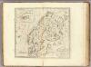
Sweden, Denmark, Norway and Finland.
1 : 8236800 Carey, Mathew
Sweden, Denmark, Norway and Finland.
1 : 8236800 Carey, Mathew
Administrativnaja Karta Evropejskoj časti C.C.C.P.

Sweden, Denmark, Norway, Finland, Iceland.
1 : 11500000 Seaman, James V.
N. European ports.
1 : 10000000 Philip, George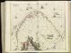
[127][130] Finmarchiae et Laplandiae Maritima ..., uit: Atlas sive Descriptio terrarum orbis
Annotatie: Gedigitaliseerde versie. Amsterdam. Heiloo : Picturae (vervaardiger), 2015. tiff-bestand. Gedigitaliseerd: 07-01-2015; Origineel: Universiteitsbibliotheek Vrije Universiteit (XL.05127.-) ; Netherlands; Titelpagina ontbreekt Wit, Frederik de Amsterdam : Frederick de Wit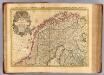
Courones du nord.
1 : 2500000 L'Isle, Guillaume de, 1675-1726
Sweden & Norway, northern, Russia.
1 : 4500000 Society for the Diffusion of Useful Knowledge (Great Britain)
Sweden, Denmark, Norway, and Finland from the Best Authorities.
1 : 6550000 Melish, John