Maps of United Kingdom
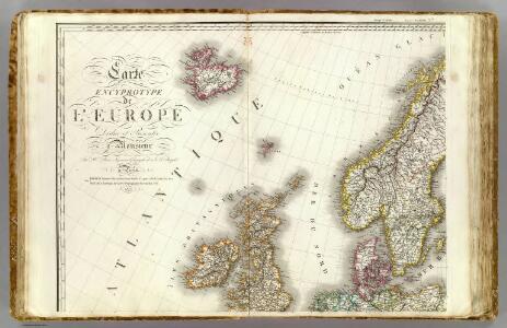
Europe 1.
1 : 3850000 Brue, Adrien Hubert, 1786-1832
Karte von Europa, 1
4 Blätter : 53 x 70 cm Verlag der Königlich-Preussischen Academie-Kunst- und Buchhandlung
Evropa, 1
1 Blatt : mehrfarbig ; 49 x 57 cm Homännische Erben
Europa befolkningskarta

Western part of the northern states including the British Islands Norway Denmark and part of Sweden
1 Blatt : 53 x 68 cm Sayer
Dänemark, Island u Färöer, Schweden und Norwegen
Hand-Atlas über alle Theile der Erde nach dem neuesten Zustande und über das Weltgebäude Stieler, Adolf bei Justus Perthes
Dänemark, Jsland u. Färöer, Schweden und Norwegen
Stieler's Hand-Atlas Stieler, Adolf bei Justus Perthes
Northern Europe. Pergamon World Atlas.
1 : 5000000 Polish Army Topography Service
Schweden, Norwegen, Daenemark.
1 : 4000000 Ziegler, J. M.
Tabula Moderna Prussie Livonie Norbegie Et Gottie. [Karte], in: [Clavdii Ptholomei Cosmographi ...], S. 263.
1 Karte aus Atlas Nicolaus Germanus [und Ptolemaeus, Claudius]
Chart shewing the track of His Majesty's sloops Racehorse and Carcass during the expedition towards the north pole 1773
1 Karte : Kupferdruck ; 43 x 20 cm Palmer s.n.
[Ethnographische Karte von Europa]
Zweiter Band, enthaltend in vier Abtheilungen die Vertheilung der Organismen: 5. Pflanzen-Geographie, 6. Thier-Geographie, 7. Anthropographie, 8. Ethnographie Humboldt, Alexander von Verlag von Justus Perthes
Evropa XIX. století: od vídeňského kongresu r. 1815, do rozhodnutí na frontách světové války r. 1918
Kašpar, Jan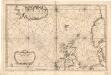
Museumskart 155: Carte Réduite De Partie De La Mer Du Nord
1 : 3000000 S. Bellin
Schweden Daenemarck u. Norwegen
Dánsko Mollo, Tranquillo Tranquillo Mollo
Russian Empire.
1 : 21000000 Greenleaf, Jeremiah
Russian Empire.
1 : 21000000 Greenleaf, Jeremiah
Länder der Nord- und Ostsee
1 : 10000000 Nordeuropa
Kaart van Noorwegen, Denemarken, ijsland, Zweden, Finland, Engeland en de Noordzee / W. Seghers
1 : 4000000 Seghers, W. Antwerpen : Patria [etc.]
North Sea, Baltic cables, wireless stations.
1 : 12500000 Philip, George
Schonlandia XIII Nova Tabula [Karte], in: Claud. Ptolemaeus. Geographia lat. cum mappis [...], S. 389.
1 Karte aus Atlas Münster, Sebastian [und Ptolemaeus, Claudius]
England, Scotland & Ireland, with the iles thereto belonging.
from A new systeme of the mathematicks: containing I. Arithmetick, as well natural and decimal, as in species, or the principles of algebra. II. Practical geometry, together with the first six books of Euclid's Elements, as also the eleventh and twelfth, symbo
Schonlandia XIII Nova Tabula [Karte], in: Geographia universalis vetus et nova complectens Claudii Ptolemaei Alexandrini enarrationis libros VIII, S. 335.
1 Karte aus Atlas Münster, Sebastian [und Ptolemaeus, Claudius]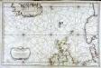
Carte réduite de partie de la mer du Nord comprise entre l'Ecosse, le Dannemark, la Norwege et l'Islande
1 Karte : Kupferdruck ; 55 x 83 cm Bellin s.n.
Tabula Europae I. [Karte], in: Geographia universalis vetus et nova complectens Claudii Ptolemaei Alexandrini enarrationis libros VIII, S. 222.
1 Karte aus Atlas Münster, Sebastian [und Ptolemaeus, Claudius]
Carte generale de toute l'Europe, 1
1 Blatt : 57 x 48 cm J.M. Will
Pas Caart van de Noort Zee .. Verthoonende in zich alle de Custen en Havens daer rontom gelegen. [Karte], in: De Nieuwe Groote Vermeerderde Zee-Atlas ofte Water-Werelt, S. 15.
1 Karte aus Atlas Doncker, Hendrick
Tabula Europae I. [Karte], in: Claud. Ptolemaeus. Geographia lat. cum mappis [...], S. 254.
1 Karte aus Atlas Münster, Sebastian [und Ptolemaeus, Claudius]
Tabula Nova Hibernie Anglie Et Scotie [Karte], in: Claudii Ptolemei viri Alexandrini mathematice discipline philosophi doctissimi geographie opus [...], S. 236.
1 Karte aus Atlas Waldseemüller, Martin [und Ptolemaeus, Claudius] Übelin, Georg