Maps of France

Geognostische Karte von Central-und West-Europa einschlieslich der Britischen Inseln, Frankreich, Deutschland und der Nachbarländer
Grosser Hand-Atlas über alle Theile der Erde in 170 Karten Meyer, J. Verlag des Bibliographischen Instituts
Karte von dem Deutschen Meere und den Angranzenden Theilen Des Atlantischen Oceans.
1 : 5500000 Berghaus, Heinrich
[Karte von dem Deutschen Meere und den ängränzenden Theilen des Atlantischen Oceans. Zur Übersicht der Fluthwellen und der Beschaffenheit des Seebodens]
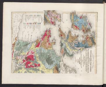
Erster Band, enthaltend in vier Abtheilungen die Erscheinungen der anorganischen Natur: 1. Meteorologie und Klimatographie. 2. Hydrologie und Hydrographie. 3. Geologie. 4. Tellurischer Magnetismus Humboldt, Alexander von Verlag von Justus Perthes
De Westkust van Europa van Texel tot Kaap Finisterre
Europe Gerard van Keulen
Carte pour l'intelligence de l'histoire d'Angleterre
1 Karte : Kupferdruck ; 26 x 26 cm, Bildgrösse 35 x 46 cm Châtelain s.n.
Les Isles Britanniques ou sont le royaumes d'Angleterre
1 : 2534400
Der Sieg im Westen [Victory in the West]

Gallia IIII. Nova Tabula [Karte], in: Geographia universalis vetus et nova complectens Claudii Ptolemaei Alexandrini enarrationis libros VIII, S. 311.
1 Karte aus Atlas Münster, Sebastian [und Ptolemaeus, Claudius]
[XII], uit: Geognostische Karte des Oesterreichischen Kaiserstaates mit einem grossen Theile Deutschland's u. Italien / hauptsachlich nach ... Haidinger's geognostischer Karte dieses Staates bearb. von Josef Scheda
1 : 3000000 titelvariant: General-Karte von Europa in 25 Blättern; Annotatie: Bijlage bij: General-Karte von Europa in 25 Blättern. - 1:2.592.000. - 1845-1847 Scheda, Joseph Wien : K.K. Militär. Geografisch. Institut
Gallia IIII. Nova Tabula [Karte], in: Claud. Ptolemaeus. Geographia lat. cum mappis [...], S. 341.
1 Karte aus Atlas Münster, Sebastian [und Ptolemaeus, Claudius]
Gallia Antiqua.
1 : 5500000 Anville, Jean Baptiste Bourguignon d, 1697-1782
Gallia Antiqua ex aevi Romani monumentis eruta, et serenissimi Carnutum ducis munificentia publici juris facta / auctor d'Anville ; [gravé par] De-la-Haye
1 : 2500000 Annotatie: Met lijst van Romeinse provincies: I-XVII; In: [Atlas du Sr. d'Anville], bl. 7; Annotatie geografische gegevens: Met schaalstokken Jean-Baptiste Bourguignon d' Anville 1697-1782; Guillaume Nicolas Delahaye 1727-1802 [Paris : apud auctorem]
[Jihozápadní Evropa]
1 : 5800000 Evropa jihozápadní
Tabula Moderna Gallie [Karte], in: Claudii Ptolemei viri Alexandrini mathematice discipline philosophi doctissimi geographie opus [...], S. 242.
1 Karte aus Atlas Waldseemüller, Martin [und Ptolemaeus, Claudius] Übelin, Georg
A new and accurate map of France with its aquisitions / composed from the latest surveys assited by the most approved maps & charts & regulated by astrol. Observations by Eman. Bowen
Bowen, Emmanuel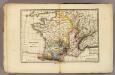
France physique.
1 : 4400000 Vincent
Carte vom Canal zwischen dem Atlantischen Meere und der Nord=See
1 Karte : Kupferdruck ; 47 x 49 cm Saltzenberg s.n.
Regnum Galliæ
1 Karte : Kupferdruck ; 46 x 58 cm Valck; Valck G. und L. Valck
Neue Orientierungkarte [von] Frankreich u[nd] Mittelmeerlä[nder]
Francie
30-31. Francia, France.
1 : 3000000 Touring club italiano

Nouvelle carte de poste de tout l'empire Français, de l'Anglettere, de l'Italie, d'une partie de l'Espagne et de l'Allemagne etc
Anglie Hinrichs, Johann Conrad J.C. Hinrichs
Landtaflen
1 Atlas [von Johannes Stumpf] Christoffel Froschower, Zürych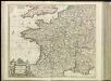
[13][13] Accuratissima Galliae tabula, uit: Atlas sive Descriptio terrarum orbis
Annotatie: Gedigitaliseerde versie. Amsterdam. Heiloo : Picturae (vervaardiger), 2015. tiff-bestand. Gedigitaliseerd: 07-01-2015; Origineel: Universiteitsbibliotheek Vrije Universiteit (XL.05127.-) ; Netherlands; Titelpagina ontbreekt Wit, Frederik de Amsterdam : Frederick de Wit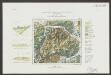
Gallia Le Royaume De France. [Karte], in: Le théâtre du monde, ou, Nouvel atlas contenant les chartes et descriptions de tous les païs de la terre, Bd. 2, S. 10.
1 Karte aus Atlas Blaeu, Willem Janszoon und Blaeu, Joan Blaeu, Willem Janszoon
Gallia transalpina in suas quatuor provincias, Narbonensem, Aqvitaniam, Lvgvdensem et Belgicam descripta
1 Karte : Kupferdruck ; 30 x 37 cm Weigel excudit C. Weigelius
Gallia vetus
1 Karte : Kupferdruck ; 30 x 38 cm Weigel ap. Chri. Weigel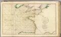
British Channel, Bay of Biscay.
1 : 3100000 Faden, William, 1750?-1836