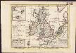
Maps of British Isles

Karte von dem Deutschen Meere und den Angranzenden Theilen Des Atlantischen Oceans.
1 : 5500000 Berghaus, Heinrich
[Karte von dem Deutschen Meere und den ängränzenden Theilen des Atlantischen Oceans. Zur Übersicht der Fluthwellen und der Beschaffenheit des Seebodens]
Erster Band, enthaltend in vier Abtheilungen die Erscheinungen der anorganischen Natur: 1. Meteorologie und Klimatographie. 2. Hydrologie und Hydrographie. 3. Geologie. 4. Tellurischer Magnetismus Humboldt, Alexander von Verlag von Justus Perthes
Westeuropa 2003
Westeuropa Kunz, Andreas ; Treiling, Thomas
Westeuropa 1990
Westeuropa Kunz, Andreas ; Treiling, Thomas
Westeuropa 1935
Westeuropa Kunz, Andreas ; Treiling, Thomas
Westeuropa 1867
Westeuropa Kunz, Andreas ; Röss, Wolf ; Johnen, Bettina ; Moeschl, Joachim Robert
Westeuropa 1839
Westeuropa Kunz, Andreas ; Röss, Wolf ; Johnen, Bettina ; Moeschl, Joachim Robert
Westeuropa 1789
Westeuropa Kunz, Andreas ; Treiling, Thomas
Westeuropa 1949
Westeuropa Kunz, Andreas ; Treiling, Thomas
Westeuropa 1871
Westeuropa Kunz, Andreas ; Röss, Wolf ; Johnen, Bettina ; Moeschl, Joachim Robert
Westeuropa 1797
Westeuropa Kunz, Andreas ; Treiling, Thomas
Westeuropa 1830
Westeuropa Kunz, Andreas ; Röss, Wolf ; Johnen, Bettina ; Moeschl, Joachim Robert
Westeuropa 1861
Westeuropa Kunz, Andreas ; Röss, Wolf ; Johnen, Bettina ; Moeschl, Joachim Robert
Carte pour l'intelligence de l'histoire d'Angleterre
1 Karte : Kupferdruck ; 26 x 26 cm, Bildgrösse 35 x 46 cm Châtelain s.n.
Westeuropa 1820
Westeuropa Kunz, Andreas ; Röss, Wolf ; Johnen, Bettina ; Moeschl, Joachim Robert
Westeuropa 1848
Westeuropa Kunz, Andreas ; Röss, Wolf ; Johnen, Bettina ; Moeschl, Joachim Robert
Westeuropa 1922
Westeuropa Kunz, Andreas ; Treiling, Thomas
Westeuropa 1812
Westeuropa Kunz, Andreas ; Treiling, Thomas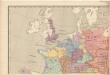
Evropa raného středověku: do konce VI. století po Kr.
Kašpar, Jan
Westeuropa 1937
Westeuropa Kunz, Andreas ; Treiling, Thomas
Westeuropa 1914
Westeuropa Kunz, Andreas ; Röss, Wolf ; Johnen, Bettina ; Moeschl, Joachim Robert
Westeuropa 1957
Westeuropa Kunz, Andreas ; Treiling, Thomas
Westeuropa 1890
Westeuropa Kunz, Andreas ; Röss, Wolf ; Johnen, Bettina ; Moeschl, Joachim Robert
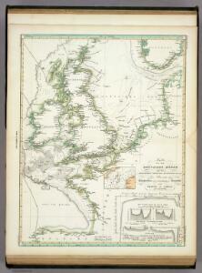
Les Isles Britanniques ou sont le royaumes d'Angleterre
1 : 2534400
Prima Europe Tabula [Karte], in: [Clavdii Ptholomei Cosmographi ...], S. 245.
1 Karte aus Atlas Nicolaus Germanus [und Ptolemaeus, Claudius]
Der Sieg im Westen [Victory in the West]
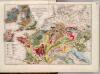
Geognost. Karte, Central- u. West-Europa.
1 : 4070000 Meyer, Joseph, 1796-1856
Geognostische Karte von Central-und West-Europa einschlieslich der Britischen Inseln, Frankreich, Deutschland und der Nachbarländer
Grosser Hand-Atlas über alle Theile der Erde in 170 Karten Meyer, J. Verlag des Bibliographischen Instituts
England und die Nordseeländer
1 : 3500000 Severní moře (oblast) Kartogr. Anst. Freytag & Berndt