Maps of Scandinavia

Carte des couronnes du nord comprenant la Suede, le Danemarc, la Norvege la Prusse etc
1 : 2600000 Dánsko Büsching, Anton Friedrich Jean Frederic Frauenholz
Composite: Schweden, Norwegen.
1 : 4500000 Flemming, Carl
Composite: Courones du nord.
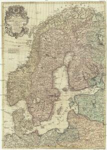
1 : 2500000 L'Isle, Guillaume de, 1675-1726
57. Scandanavia, Political. The World Atlas.
1 : 5000000 USSR (Union of Soviet Socialist Republics).
[Neuer Atlas der ganzen Erde nach den neuesten Bestimmungen ... : XII.] Schweden, Norwegen und Daenemark
Nach den besten Materialien entworfen von F.W. Streit Leipzig : J.C. Hinrichssche Buchhandlung
Schweden, Norwegen und Dänemark
Schul-Atlas über alle Theile der Erde nach dem neuesten Zustande, und über das Weltgebäude Stieler, Adolf bei Justus Perthes
General Karte von König[reich] Schweden und Norwegen : nebst Daenemark, nach den neuesten und zuverlässigsten Hülfsmitteln
1 : 3000000 Augsburg : Walch
Scandinavia.
1 : 3350000 Pinkerton, John, 1758-1826
Sweden and Norway
A new general atlas of modern geography, consisting of a complete collection of maps of the four quarters of the globe Wyld, James James Wyld
Sweden, Norway and Denmark
1 : 6100000 Dánsko Walker, C. Society for the Diffusion of Useful Knowledge
Denmark, Sweden, Norway.
1 : 7900000 Tanner, Henry S.
Schweden, Norwegen.
1 : 6400000 Flemming, Carl
Suede, Norvege, Danemark.
1 : 5400000 Garnier, F. A., 1803-1863
Suede, Norvege, Danemark.
1 : 4500000 Brue, Adrien Hubert, 1786-1832
Suede, Norvege, et Danemark.
1 : 5900000 Monin, C.V.
Statistikk 42: Døgnets normaltemperatur i Skandinavia, juli måned
1 : 4000000
Scandia, Scandinavia.
1 : 3050000 Faden, William, 1750?-1836
Carte du Royaume de Suede,Norwege et Danemarck.
1 : 4800000 Vivien de St Martin, L.
Suede, Norvege, et Danemark.
1 : 5300000 Montemont, A.
Denmark, Sweden & Norway.
1 : 6800000 Greenleaf, Jeremiah
Denmark, Sweden & Norway.
1 : 6700000 Greenleaf, Jeremiah
Hollande et Belgique, Suede et Danemark.
Andriveau-Goujon, J.
Skandinavien oder Schweden und Norwegen
Schul-Atlas in 36 Karten Völter, Daniel Verlag der J.M. Dannheimer'schen Buchhandlung
Sweden and Norway.
1 : 7950000 Lucas, Fielding Jr.
Schweden, Norwegen und Dänemark
Schul-Atlas über alle Theile der Erde nach dem neuesten Zustande, und über das Weltgebäude Stieler, Adolf Justus Perthes
Scandinavia.
1 : 4800000 Lizars, Daniel
Nordeuropa 1991
Nordeuropa Kunz, Andreas ; Treiling, Thomas
Nordeuropa 1867
Nordeuropa Kunz, Andreas ; Röss, Wolf ; Johnen, Bettina ; Moeschl, Joachim Robert
Denmark, Sweden and Norway. Germany.
1 : 6600000 Schonberg & Co.