Maps of Scandinavia

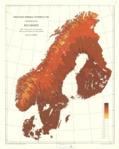
Statistikk 42: Døgnets normaltemperatur i Skandinavia, juli måned
1 : 4000000
Skandinavien oder Schweden und Norwegen
Schul-Atlas in 36 Karten Völter, Daniel Verlag der J.M. Dannheimer'schen Buchhandlung
Statistikk 42: Døgnets normaltemperatur i Skandinavia, oktober måned
1 : 4000000
[Scandinavien und Dänemark]
[Allgemeiner Atlas über alle Theile der Erde in 29 Blättern] Ziegler, Jakob Melchior Top. Anstalt v. J. Wurster u. Comp.
Statistikk 42: Døgnets normaltemperatur i Skandinavia, januar måned
1 : 4000000
[Schweden und Norwegen oder Scandinavische Halbinsel Königreich Daenemark]
Geographischer Atlas über alle Theile der Erde Ziegler, Jakob Melchior Verlag von Dietrich Reimer
Statistikk 42: Døgnets normaltemperatur i Skandinavia, april måned
1 : 4000000
Nordeuropa 1789
Nordeuropa Kunz, Andreas ; Treiling, Thomas
Nordeuropa 1865
Nordeuropa Kunz, Andreas ; Röss, Wolf ; Johnen, Bettina ; Moeschl, Joachim Robert
Karte der beiden Königreiche Schweden u. Norwegen
Neuester Schul-Atlas Walch, Johann im Verlag bei Joh. Walch
Nordeuropa 1914
Nordeuropa Kunz, Andreas ; Röss, Wolf ; Johnen, Bettina ; Moeschl, Joachim Robert

Nordeuropa 1809
Nordeuropa Kunz, Andreas ; Treiling, Thomas
Nordeuropa 1815
Nordeuropa Kunz, Andreas ; Treiling, Thomas
Nordeuropa 1937
Nordeuropa Kunz, Andreas ; Treiling, Thomas
Nordeuropa 1949
Nordeuropa Kunz, Andreas ; Treiling, Thomas
Skandinavien
Plastischer Schul-Atlas über alle Theile der Erde : in 24 Karten Woldermann, G Verlag von P. Eckerlein
Nordeuropa 1871
Nordeuropa Kunz, Andreas ; Röss, Wolf ; Johnen, Bettina ; Moeschl, Joachim Robert
Nordeuropa 1820
Nordeuropa Kunz, Andreas ; Röss, Wolf ; Johnen, Bettina ; Moeschl, Joachim Robert

Schweden, Norwegen und Dänemark
Schul-Atlas über alle Theile der Erde nach dem neuesten Zustande, und über das Weltgebäude Stieler, Adolf bei Justus Perthes
Sweden and Norway
A new general atlas of modern geography, consisting of a complete collection of maps of the four quarters of the globe Wyld, James James Wyld
Nordeuropa 1905
Nordeuropa Kunz, Andreas ; Röss, Wolf ; Johnen, Bettina ; Moeschl, Joachim Robert
Nordeuropa 1814
Nordeuropa Kunz, Andreas ; Treiling, Thomas
Sweden & Norway.
1 : 7480000 Tanner, Henry S.
Spesielle kart 130-2: Oversigt over tætbebyggelse, stà ̧rre industrielle bedrifter og vigtige gruber ...
1 : 2800000
Sweden, Denmark, Norway (outline)
1 : 8500000 Patteson, Edward
Sweden, Denmark, Norway.
1 : 8500000 Patteson, Edward
Suede, Norvege, Danemark.
1 : 4500000 Brue, Adrien Hubert, 1786-1832