Maps of Scandinavia

Schweden, Norwegen und Dänemark
Schul-Atlas über alle Theile der Erde nach dem neuesten Zustande, und über das Weltgebäude Stieler, Adolf bei Justus Perthes
Sweden and Norway
A new general atlas of modern geography, consisting of a complete collection of maps of the four quarters of the globe Wyld, James James Wyld
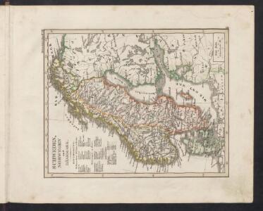
[Neuer Atlas der ganzen Erde nach den neuesten Bestimmungen ... : XII.] Schweden, Norwegen und Daenemark
Nach den besten Materialien entworfen von F.W. Streit Leipzig : J.C. Hinrichssche Buchhandlung
Statistikk 42: Døgnets normaltemperatur i Skandinavia, juli måned
1 : 4000000
Scandinavien
Neuer Handatlas über alle Theile der Erde Kiepert, Heinrich Verlag von Dietrich Reimer
[Scandinavien und Dänemark]
[Allgemeiner Atlas über alle Theile der Erde in 29 Blättern] Ziegler, Jakob Melchior Top. Anstalt v. J. Wurster u. Comp.
Skandinavien oder Schweden und Norwegen
Schul-Atlas in 36 Karten Völter, Daniel Verlag der J.M. Dannheimer'schen Buchhandlung
Suede, Norvege, Danemark.
1 : 4500000 Brue, Adrien Hubert, 1786-1832
Scandia, Scandinavia.
1 : 3050000 Faden, William, 1750?-1836
Suede, Norvege, et Danemark.
1 : 5900000 Monin, C.V.
Composite: Courones du nord.
1 : 2500000 L'Isle, Guillaume de, 1675-1726
Statistikk 42: Døgnets normaltemperatur i Skandinavia, oktober måned
1 : 4000000
Schweden, Norwegen und Dänemark
Schul-Atlas über alle Theile der Erde nach dem neuesten Zustande, und über das Weltgebäude Stieler, Adolf Justus Perthes
[Schweden und Norwegen oder Scandinavische Halbinsel Königreich Daenemark]
Geographischer Atlas über alle Theile der Erde Ziegler, Jakob Melchior Verlag von Dietrich Reimer
Nordeuropa 1789
Nordeuropa Kunz, Andreas ; Treiling, Thomas
Karte der beiden Königreiche Schweden u. Norwegen
Neuester Schul-Atlas Walch, Johann im Verlag bei Joh. Walch
Nordeuropa 1991
Nordeuropa Kunz, Andreas ; Treiling, Thomas
Nordeuropa 1867
Nordeuropa Kunz, Andreas ; Röss, Wolf ; Johnen, Bettina ; Moeschl, Joachim Robert
Scandinavien bis zur calmarischen Union, 1397.
1 : 6000000 Spruner von Merz, Karl
Statistikk 42: Døgnets normaltemperatur i Skandinavia, januar måned
1 : 4000000
Sweden and Norway.
1 : 7950000 Lucas, Fielding Jr.

Statistikk 42: Døgnets normaltemperatur i Skandinavia, april måned
1 : 4000000
Nordeuropa 1914
Nordeuropa Kunz, Andreas ; Röss, Wolf ; Johnen, Bettina ; Moeschl, Joachim Robert
Nordeuropa 1871
Nordeuropa Kunz, Andreas ; Röss, Wolf ; Johnen, Bettina ; Moeschl, Joachim Robert
Nordeuropa 1905
Nordeuropa Kunz, Andreas ; Röss, Wolf ; Johnen, Bettina ; Moeschl, Joachim Robert
Nordeuropa 1865
Nordeuropa Kunz, Andreas ; Röss, Wolf ; Johnen, Bettina ; Moeschl, Joachim Robert
Nordeuropa 1809
Nordeuropa Kunz, Andreas ; Treiling, Thomas
Nordeuropa 1815
Nordeuropa Kunz, Andreas ; Treiling, Thomas