Maps of Scandinavia

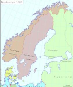
Nordeuropa 1867
Nordeuropa Kunz, Andreas ; Röss, Wolf ; Johnen, Bettina ; Moeschl, Joachim Robert
Schweden und Norwegen
E. von Sydow's Schul-Atlas in sechs und dreissig Karten Sydow, Emil von bei Justus Perthes
Nordeuropa 1991
Nordeuropa Kunz, Andreas ; Treiling, Thomas
Nordeuropa 1789
Nordeuropa Kunz, Andreas ; Treiling, Thomas
Suede, Norvege, et Danemark.
1 : 5900000 Monin, C.V.
Scandinavien bis zur calmarischen Union, 1397.
1 : 6000000 Spruner von Merz, Karl
Scandinavien
Neuer Handatlas über alle Theile der Erde Kiepert, Heinrich Verlag von Dietrich Reimer
Nordeuropa 1949
Nordeuropa Kunz, Andreas ; Treiling, Thomas
Statistikk 42: Døgnets normaltemperatur i Skandinavia, januar måned
1 : 4000000
Nordeuropa 1865
Nordeuropa Kunz, Andreas ; Röss, Wolf ; Johnen, Bettina ; Moeschl, Joachim Robert
Nordeuropa 1820
Nordeuropa Kunz, Andreas ; Röss, Wolf ; Johnen, Bettina ; Moeschl, Joachim Robert
Statistikk 42: Døgnets normaltemperatur i Skandinavia, oktober måned
1 : 4000000

Nordeuropa 1814
Nordeuropa Kunz, Andreas ; Treiling, Thomas
Scandia, Scandinavia.
1 : 3050000 Faden, William, 1750?-1836
Schweden, Norwegen und Dänemark
Schul-Atlas über alle Theile der Erde nach dem neuesten Zustande, und über das Weltgebäude Stieler, Adolf Justus Perthes
Statistikk 42: Døgnets normaltemperatur i Skandinavia, april måned
1 : 4000000
Nordeuropa 1815
Nordeuropa Kunz, Andreas ; Treiling, Thomas
Nordeuropa 1914
Nordeuropa Kunz, Andreas ; Röss, Wolf ; Johnen, Bettina ; Moeschl, Joachim Robert
Suede, Norvege, Danemark.
1 : 4500000 Brue, Adrien Hubert, 1786-1832
Nordeuropa 1809
Nordeuropa Kunz, Andreas ; Treiling, Thomas
Denmark, Sweden, Norway.
1 : 7900000 Tanner, Henry S.
Nordeuropa 1937
Nordeuropa Kunz, Andreas ; Treiling, Thomas
[Neuer Atlas der ganzen Erde nach den neuesten Bestimmungen ... : XII.] Schweden, Norwegen und Daenemark
Nach den besten Materialien entworfen von F.W. Streit Leipzig : J.C. Hinrichssche Buchhandlung
Nordeuropa 1905
Nordeuropa Kunz, Andreas ; Röss, Wolf ; Johnen, Bettina ; Moeschl, Joachim Robert
Karte der beiden Königreiche Schweden u. Norwegen
Neuester Schul-Atlas Walch, Johann im Verlag bei Joh. Walch
Sweden & Norway.
1 : 7480000 Tanner, Henry S.
Nordeuropa 1871
Nordeuropa Kunz, Andreas ; Röss, Wolf ; Johnen, Bettina ; Moeschl, Joachim Robert
Skandinavien oder Schweden und Norwegen
Schul-Atlas in 36 Karten Völter, Daniel Verlag der J.M. Dannheimer'schen Buchhandlung