Maps of Scandinavia

Scandinavien
Neuer Handatlas über alle Theile der Erde Kiepert, Heinrich Verlag von Dietrich Reimer
Scandinavien bis zur calmarischen Union, 1397.
1 : 6000000 Spruner von Merz, Karl
Nordeuropa 1809
Nordeuropa Kunz, Andreas ; Treiling, Thomas
Nordeuropa 1937
Nordeuropa Kunz, Andreas ; Treiling, Thomas
Scandia, Scandinavia.
1 : 3050000 Faden, William, 1750?-1836
Nordeuropa 1905
Nordeuropa Kunz, Andreas ; Röss, Wolf ; Johnen, Bettina ; Moeschl, Joachim Robert
Nordeuropa 1815
Nordeuropa Kunz, Andreas ; Treiling, Thomas
Nordeuropa 1820
Nordeuropa Kunz, Andreas ; Röss, Wolf ; Johnen, Bettina ; Moeschl, Joachim Robert
Nordeuropa 1914
Nordeuropa Kunz, Andreas ; Röss, Wolf ; Johnen, Bettina ; Moeschl, Joachim Robert
Nordeuropa 1814
Nordeuropa Kunz, Andreas ; Treiling, Thomas
Nordeuropa 1871
Nordeuropa Kunz, Andreas ; Röss, Wolf ; Johnen, Bettina ; Moeschl, Joachim Robert
Nordeuropa 1949
Nordeuropa Kunz, Andreas ; Treiling, Thomas
Nordeuropa 1865
Nordeuropa Kunz, Andreas ; Röss, Wolf ; Johnen, Bettina ; Moeschl, Joachim Robert
Nordeuropa 1789
Nordeuropa Kunz, Andreas ; Treiling, Thomas
Nástěnná mapa Evropy

Sweden, Denmark, Norway and Finland.
1 : 6400000 Carey, Mathew
Nordeuropa 1867
Nordeuropa Kunz, Andreas ; Röss, Wolf ; Johnen, Bettina ; Moeschl, Joachim Robert
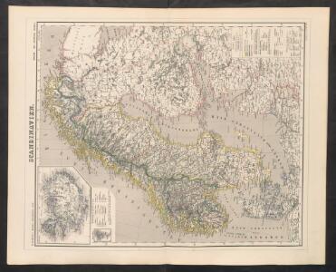
Schweden und Norwegen
E. von Sydow's Schul-Atlas in sechs und dreissig Karten Sydow, Emil von bei Justus Perthes
Suecia, Dania, Et Norvegia, Regna Europae Septentrionalia. [...] [Karte], in: Theatrum orbis terrarum, sive, Atlas novus, Bd. 1, S. 53.
1 Karte aus Atlas Blaeu, Joan Blaeu, Willem Janszoon
Nieuwe kaart van Noord-Europa / door A. de Moor
1 : 3250000 Moor, A. de (fl. 1920) [S.l. : Zijlstra]
Sweden & Norway.
1 : 7400000 Mitchell, Samuel Augustus
Sweden & Norway.
1 : 7400000 Mitchell, Samuel Augustus
Schweden, Norwegen und Dänemark
Schul-Atlas über alle Theile der Erde nach dem neuesten Zustande, und über das Weltgebäude Stieler, Adolf bei Justus Perthes
Karte der beiden Königreiche Schweden u. Norwegen
Neuester Schul-Atlas Walch, Johann im Verlag bei Joh. Walch
Statistikk 42: Døgnets normaltemperatur i Skandinavia, oktober måned
1 : 4000000
Denmark, Sweden, and Norway.
1 : 7800000 Finley, Anthony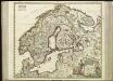
[63][63] Scandinaviae tabula comprehendens Regnorum Sueciae, Daniae et Norvegiae ..., uit: Atlas sive Descriptio terrarum orbis
Annotatie: Gedigitaliseerde versie. Amsterdam. Heiloo : Picturae (vervaardiger), 2015. tiff-bestand. Gedigitaliseerd: 07-01-2015; Origineel: Universiteitsbibliotheek Vrije Universiteit (XL.05127.-) ; Netherlands; Titelpagina ontbreekt Wit, Frederik de Amsterdam : Frederick de Wit
Denmark, Sweden, Norway.
1 : 7900000 Tanner, Henry S.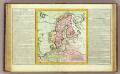
Suede, Dannemarck, Norwege.
1 : 8500000 Clouet, J. B. L. (Jean-Baptiste Louis), b. 1730