Maps of Scandinavia
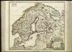
[63][63] Scandinaviae tabula comprehendens Regnorum Sueciae, Daniae et Norvegiae ..., uit: Atlas sive Descriptio terrarum orbis
Annotatie: Gedigitaliseerde versie. Amsterdam. Heiloo : Picturae (vervaardiger), 2015. tiff-bestand. Gedigitaliseerd: 07-01-2015; Origineel: Universiteitsbibliotheek Vrije Universiteit (XL.05127.-) ; Netherlands; Titelpagina ontbreekt Wit, Frederik de Amsterdam : Frederick de Wit
Tabula exactissima Regnorum Sueciae et Norvegiae, nec non Maris Universi Orientalis [...] [Karte], in: Novus atlas absolutissimus, Bd. 1, S. 45.
1 Karte aus Atlas Janssonius Offizin
Sueciae, Norvegiae, et Daniae, Nova Tabula. [Karte], in: Novus atlas absolutissimus, Bd. 1, S. 42.
1 Karte aus Atlas Janssonius Offizin
Suecia, Dania, Et Norvegia, Regna Europae Septentrionalia. [Karte], in: Le théâtre du monde, ou, Nouvel atlas contenant les chartes et descriptions de tous les païs de la terre, Bd. 1, S. 55.
1 Karte aus Atlas Blaeu, Willem Janszoon und Blaeu, Joan Blaeu, Willem Janszoon
Sweden, Denmark, Norway and Finland.
1 : 6400000 Carey, Mathew
Tabula exactissima Regnorum SUECIAE et NORVEGIAE, nec non MARIS UNIVERSI ORIENTALIS, Terarumq. adjacentium
1 : 5100000 Norsko Bureus, Andreas Goos, Abraham a Nicolao Iohannide Piscatore
Nieuwe kaart van Noorwegen, Zweden, Denemarken en een gedeelte van Rusland
1 : 12500000 [S.l.] : [s.n.]
Suecia, Dania, Et Norvegia, Regna Europae Septentrionalia. [...] [Karte], in: Theatrum orbis terrarum, sive, Atlas novus, Bd. 1, S. 53.
1 Karte aus Atlas Blaeu, Joan Blaeu, Willem Janszoon
Svecia, Dania, Et Norvegia, Regna Europae Septentrionalia [Karte], in: Novus Atlas, das ist, Weltbeschreibung, Bd. 1, S. 39.
1 Karte aus Atlas Blaeu, Joan Blaeu, Willem Janszoon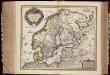
Tabula exactissima Regnorum Sueciae et Norvegiae, nec non Maris Universi Orientalis, terrarumq. adjacentium / summo studio ab Andrea Bureo Sueco in lucem edita ; noviter seria cura, singulariq. zelo, dedicatur humillimè Gustavo Adolpho ... a Nicolao Iohannide Piscatore ; Abraham Goos sculpsit
1 : 4700000 Annotatie: Origineel is Blad 141 in atlas factice; Annotatie geografische gegevens: Met 6 schaalstokken Claes Jansz. Visscher 1586/1587-1652; Andreas Bureus 1571-1646; Abraham Goos ca. 1589/90-1643 [Amsterdam : Nicolaus Johannis Piscator]
Exactissima totius Scandinaviae tabula
Skandinávie Visscher, Nicolaes Jansz. Siebert, Selmar per Nicolaum Visscher
Nieuwe kaart van Noord-Europa / door A. de Moor
1 : 3250000 Moor, A. de (fl. 1920) [S.l. : Zijlstra]
Scandinavien bis zum Frieden von Friedrichshamm 1809.
1 : 6000000 Spruner von Merz, Karl
SVECIA, | DANIA, ET NORVEGIA, | Regna Europæ Septentrionalia.
Iuxta Archetypum Andreæ Buræi de Boo, | Secretarij Regij, et supremi Regni Sueciæ | Architecti. [Amsterdam : Joan Blaeu]
Carte generale de toute l'Europe, 2
1 Blatt : 56 x 46 cm J.M. Will
Scandinavia complectens Sueciæ, Daniæ & Norvegiæ regna
1 Karte : Kupferdruck ; 47 x 54 cm Homann Johann Baptist Homann
Scandinavia complectens Sueciæ Daniæ & Norvegiæ regna
1 Karte : Kupferdruck ; 47 x 55 cm Homann Johann Baptist Homann
Scandinavia complectens Sueciæ, Daniæ & Norvegiæ regna
1 Karte : Kupferdruck ; 47 x 56 cm Homann Johann Baptist Homann
Scandinavia complectens Sueciae, Daniae & Norvegiae regna
1 : 4400000 Dánsko Homann, Johann Baptist Hommanovi dědicové
Scandinavia complectens Sueciae, Daniae & Norvegiae regna
1 : 4400000 Dánsko Homann, Johann Baptist J.B. Homann
SCANDINAVIA complectens SUECIAE, DANIAE & NORVEGIAE REGNA
1 : 4500000 Dánsko Homann, Johann Baptist ex tabulis Ioh. Bapt. Homanni
SCANDINAVIA complectens SUECIAE, DANIAE & NORVEGIAE REGNA
1 : 4500000 Dánsko Homann, Johann Baptist ex tabulis Ioh. Bapt. Homanni
Spannungen in Nordeuropa
1 : 5000000 Evropa severní List & von Bressensdorf
Homannův atlas světa
1 : 5000000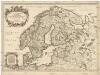
La Scandinavie et les environs
1 : 4800000 Dánsko Sanson, Guillaume Cordier, Louis chez H. Iaillot
Der Westhandel Nordosteuropas in der Frühen Neuzeit
Europa (Nordost) Handel
La Scandinavie et les environs, ou sont les royaumes de Suede, de Danemark, et de Norwege
1 : 4800000 Dánsko Sanson, Guillaume Schenk, Pieter chez Pierre Schenk
Schweden und Norwegen
1 : 11400000 Dánsko
Sweden, Denmark, Norway.
1 : 8500000 Darton, William
![[63][63] Scandinaviae tabula comprehendens Regnorum Sueciae, Daniae et Norvegiae ..., uit: Atlas sive Descriptio terrarum orbis](https://images-2.georeferencer.com/images/iiif/695039124469/full/,300/0/native.jpg)

