Maps of Scandinavia

Scandinavien bis zum Frieden von Friedrichshamm 1809.
1 : 6000000 Spruner von Merz, Karl
Scandinavia complectens Sueciae, Daniae & Norvegiae regna
1 : 4400000 Dánsko Homann, Johann Baptist Hommanovi dědicové
Scandinavia complectens Sueciae, Daniae & Norvegiae regna
1 : 4400000 Dánsko Homann, Johann Baptist J.B. Homann
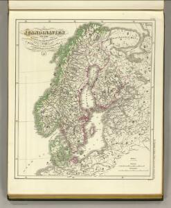
SCANDINAVIA complectens SUECIAE, DANIAE & NORVEGIAE REGNA
1 : 4500000 Dánsko Homann, Johann Baptist ex tabulis Ioh. Bapt. Homanni
SCANDINAVIA complectens SUECIAE, DANIAE & NORVEGIAE REGNA
1 : 4500000 Dánsko Homann, Johann Baptist ex tabulis Ioh. Bapt. Homanni
Tabula exactissima Regnorum SUECIAE et NORVEGIAE, nec non MARIS UNIVERSI ORIENTALIS, Terarumq. adjacentium
1 : 5100000 Norsko Bureus, Andreas Goos, Abraham a Nicolao Iohannide Piscatore
Accuratissima regnorum Sueciae, Daniae, et Norvegiae, tabula
1 : 4000000 1 Karte : Kupferdruck ; 49 x 57 cm Danckerts, Justus [Danckerts]
Scandinavia complectens Sueciæ, Daniæ & Norvegiæ regna
1 Karte : Kupferdruck ; 47 x 54 cm Homann Johann Baptist Homann
Scandinavia complectens Sueciæ Daniæ & Norvegiæ regna
1 Karte : Kupferdruck ; 47 x 55 cm Homann Johann Baptist Homann
Scandinavia complectens Sueciæ, Daniæ & Norvegiæ regna
1 Karte : Kupferdruck ; 47 x 56 cm Homann Johann Baptist Homann
SUECIAE Regnum cum vicinis Regionibus
Finsko
Charta öfwer Swerige med tilgränsande länder
1 : 3700000 Rusko severozápadní Hermelin, S.G. Akerland, A.
Scandinavia complectens Sveciæ, Daniæ et Norvegiæ regna
1 Karte : Kupferdruck ; 47 x 54 cm Böhme cura Homannianorum Heredum
Scandinavia complectens Sveciæ, Daniæ et Norvegiæ regna
1 Karte : Kupferdruck ; 47 x 54 cm Böhme cura Homannianorum Heredum
Scandinavia complectens Sveciæ, Daniæ et Norvegiæ regna
1 Karte : Kupferdruck ; 47 x 54 cm Böhme cura Homannianorum Heredum
Scandinavia complectens Sveciæ, Daniæ et Norvegiæ regna
1 Karte : Kupferdruck ; 47 x 54 cm Böhme cura Homannianorum Heredum
Scandinavia complectens Sveciæ, Daniæ et Norvegiæ regna
1 Karte : Kupferdruck ; 47 x 54 cm Böhme cura Homannianorum Heredum
Scandinavia complectens Sveciæ, Daniæ et Norvegiæ regna
1 Karte : Kupferdruck ; 47 x 54 cm Böhme cura Homannianorum Heredum
La Scandinavie et les environs, ou sont les royaumes de Suede, de Danemark, et de Norwege
1 : 4800000 Dánsko Sanson, Guillaume Schenk, Pieter chez Pierre Schenk
Exactissima totius Scandinaviae tabula
Skandinávie Visscher, Nicolaes Jansz. Siebert, Selmar per Nicolaum Visscher
Accuratissima regnorum Sueciae, Daniae et Norvegiae, tabula
1 : 4600000 Dánsko Danckerts, Justus per I. Danckers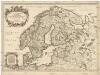
La Scandinavie et les environs
1 : 4800000 Dánsko Sanson, Guillaume Cordier, Louis chez H. Iaillot
Synopsis plagae septentrionalis, sive Sueciae Daniae et Norwegiae regn. accuratissime delineatum
Švédsko Seutter, Matthäus Lotter, Tobias Conrad studio Matth. Seütteri
Sweden, Denmark, Norway, and Finland from the Best Authorities.
1 : 6550000 Melish, John
Nieuwe kaart van Noorwegen, Zweden, Denemarken en een gedeelte van Rusland
1 : 12500000 [S.l.] : [s.n.]
Suede, Danemarck et Norwege.
1 : 6900000 Janvier, Jean
[63][63] Scandinaviae tabula comprehendens Regnorum Sueciae, Daniae et Norvegiae ..., uit: Atlas sive Descriptio terrarum orbis
Annotatie: Gedigitaliseerde versie. Amsterdam. Heiloo : Picturae (vervaardiger), 2015. tiff-bestand. Gedigitaliseerd: 07-01-2015; Origineel: Universiteitsbibliotheek Vrije Universiteit (XL.05127.-) ; Netherlands; Titelpagina ontbreekt Wit, Frederik de Amsterdam : Frederick de Wit
Sweden, Denmark, Norway.
1 : 8500000 Darton, William
Karte des Baltischen Meeres
Baltské moře (oblast) Artaria