Maps of Scandinavia
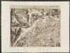
Suecia, Dania, Et Norvegia, Regna Europae Septentrionalia. [...] [Karte], in: Theatrum orbis terrarum, sive, Atlas novus, Bd. 1, S. 53.
1 Karte aus Atlas Blaeu, Joan Blaeu, Willem Janszoon
Svecia, Dania, Et Norvegia, Regna Europae Septentrionalia [Karte], in: Novus Atlas, das ist, Weltbeschreibung, Bd. 1, S. 39.
1 Karte aus Atlas Blaeu, Joan Blaeu, Willem Janszoon
Suecia, Dania, Et Norvegia, Regna Europae Septentrionalia. [Karte], in: Le théâtre du monde, ou, Nouvel atlas contenant les chartes et descriptions de tous les païs de la terre, Bd. 1, S. 55.
1 Karte aus Atlas Blaeu, Willem Janszoon und Blaeu, Joan Blaeu, Willem Janszoon
Tabula exactissima Regnorum Sueciae et Norvegiae, nec non Maris Universi Orientalis [...] [Karte], in: Novus atlas absolutissimus, Bd. 1, S. 45.
1 Karte aus Atlas Janssonius Offizin
Nieuwe kaart van Noord-Europa / door A. de Moor
1 : 3250000 Moor, A. de (fl. 1920) [S.l. : Zijlstra]
SVECIA, | DANIA, ET NORVEGIA, | Regna Europæ Septentrionalia.
Iuxta Archetypum Andreæ Buræi de Boo, | Secretarij Regij, et supremi Regni Sueciæ | Architecti. [Amsterdam : Joan Blaeu]
Schweden und Norwegen
1 : 11400000 Dánsko
Sweden, Denmark, Norway and Finland.
1 : 6400000 Carey, Mathew
Nieuwe kaart van Noorwegen, Zweden, Denemarken en een gedeelte van Rusland
1 : 12500000 [S.l.] : [s.n.]
Sueciae, Norvegiae, et Daniae, Nova Tabula. [Karte], in: Novus atlas absolutissimus, Bd. 1, S. 42.
1 Karte aus Atlas Janssonius Offizin
Tabula exactissima Regnorum Sueciae et Norvegiae, nec non Maris Universi Orientalis, terrarumq. adjacentium / summo studio ab Andrea Bureo Sueco in lucem edita ; noviter seria cura, singulariq. zelo, dedicatur humillimè Gustavo Adolpho ... a Nicolao Iohannide Piscatore ; Abraham Goos sculpsit
1 : 4700000 Annotatie: Origineel is Blad 141 in atlas factice; Annotatie geografische gegevens: Met 6 schaalstokken Claes Jansz. Visscher 1586/1587-1652; Andreas Bureus 1571-1646; Abraham Goos ca. 1589/90-1643 [Amsterdam : Nicolaus Johannis Piscator]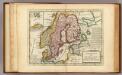
Sweden and Norway.
1 : 9600000 Moll, Herman, d. 1732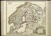
[63][63] Scandinaviae tabula comprehendens Regnorum Sueciae, Daniae et Norvegiae ..., uit: Atlas sive Descriptio terrarum orbis
Annotatie: Gedigitaliseerde versie. Amsterdam. Heiloo : Picturae (vervaardiger), 2015. tiff-bestand. Gedigitaliseerd: 07-01-2015; Origineel: Universiteitsbibliotheek Vrije Universiteit (XL.05127.-) ; Netherlands; Titelpagina ontbreekt Wit, Frederik de Amsterdam : Frederick de Wit

Exactissima totius Scandinaviae tabula
Skandinávie Visscher, Nicolaes Jansz. Siebert, Selmar per Nicolaum Visscher
La Scandinavie.
1 : 4200000 Lapie, M. (Pierre), 1779-1850
Tabula exactissima Regnorum SUECIAE et NORVEGIAE, nec non MARIS UNIVERSI ORIENTALIS, Terarumq. adjacentium
1 : 5100000 Norsko Bureus, Andreas Goos, Abraham a Nicolao Iohannide Piscatore
Carte generale de toute l'Europe, 2
1 Blatt : 56 x 46 cm J.M. Will
Nordeuropa 1820
Nordeuropa Kunz, Andreas ; Röss, Wolf ; Johnen, Bettina ; Moeschl, Joachim Robert
Nordeuropa 1814
Nordeuropa Kunz, Andreas ; Treiling, Thomas
Nordeuropa 1937
Nordeuropa Kunz, Andreas ; Treiling, Thomas
Spannungen in Nordeuropa
1 : 5000000 Evropa severní List & von Bressensdorf
Nordeuropa 1949
Nordeuropa Kunz, Andreas ; Treiling, Thomas
La Scandinavie et les environs, ou sont les royaumes de Suede, de Danemark, et de Norwege
1 : 4800000 Dánsko Sanson, Guillaume Schenk, Pieter chez Pierre Schenk
Nordeuropa 1809
Nordeuropa Kunz, Andreas ; Treiling, Thomas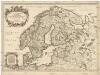
La Scandinavie et les environs
1 : 4800000 Dánsko Sanson, Guillaume Cordier, Louis chez H. Iaillot
[Skandinavien]
Skandinávie
Nordeuropa 1815
Nordeuropa Kunz, Andreas ; Treiling, Thomas
Nordeuropa 1905
Nordeuropa Kunz, Andreas ; Röss, Wolf ; Johnen, Bettina ; Moeschl, Joachim Robert
![Suecia, Dania, Et Norvegia, Regna Europae Septentrionalia. [...] [Karte], in: Theatrum orbis terrarum, sive, Atlas novus, Bd. 1, S. 53.](https://images-2.georeferencer.com/images/iiif/573863808869/full/,300/0/native.jpg)

