Maps of Scandinavia

Scandia, Scandinavia.
1 : 3050000 Faden, William, 1750?-1836
Scandinavien bis zur calmarischen Union, 1397.
1 : 6000000 Spruner von Merz, Karl
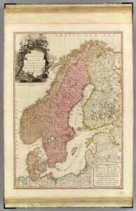
Scandinavien
Neuer Handatlas über alle Theile der Erde Kiepert, Heinrich Verlag von Dietrich Reimer
Denmark, Sweden, Norway.
1 : 7900000 Tanner, Henry S.
Suede, Norvege, Danemark.
1 : 4500000 Brue, Adrien Hubert, 1786-1832
Sweden, Denmark, Norway and Finland.
1 : 6400000 Carey, Mathew
Scandinavia.
1 : 4800000 Lizars, Daniel
Composite: Courones du nord.
1 : 2500000 L'Isle, Guillaume de, 1675-1726
Nástěnná mapa Evropy

Statistikk 42: Døgnets normaltemperatur i Skandinavia, oktober måned
1 : 4000000
Nordeuropa 1949
Nordeuropa Kunz, Andreas ; Treiling, Thomas
Suede, Norvege, et Danemark.
1 : 5900000 Monin, C.V.
Statistikk 42: Døgnets normaltemperatur i Skandinavia, januar måned
1 : 4000000
Spesielle kart 130-2: Oversigt over tætbebyggelse, stà ̧rre industrielle bedrifter og vigtige gruber ...
1 : 2800000

Nordeuropa 1820
Nordeuropa Kunz, Andreas ; Röss, Wolf ; Johnen, Bettina ; Moeschl, Joachim Robert
La Scandinavie.
1 : 4200000 Lapie, M. (Pierre), 1779-1850
Nordeuropa 1814
Nordeuropa Kunz, Andreas ; Treiling, Thomas
Zweiter Theil der Karte von Europa welcher Dænemark, und Norwegen, Schweden, und Russland enthælt, 2
1 Blatt : 72 x 54 cm F.A. Schrämbl
Seconde partie de la carte d'Europe contenant le Danemark et la Norwege, la Suède et la Russie (a l'exeption de l'Ukraine), 2
1 Blatt : 71 x 53 cm chez l'auteur
Nordeuropa 1937
Nordeuropa Kunz, Andreas ; Treiling, Thomas
Nordeuropa 1914
Nordeuropa Kunz, Andreas ; Röss, Wolf ; Johnen, Bettina ; Moeschl, Joachim Robert
Nordeuropa 1809
Nordeuropa Kunz, Andreas ; Treiling, Thomas
Nieuwe kaart van Noord-Europa / door A. de Moor
1 : 3250000 Moor, A. de (fl. 1920) [S.l. : Zijlstra]
Nordeuropa 1867
Nordeuropa Kunz, Andreas ; Röss, Wolf ; Johnen, Bettina ; Moeschl, Joachim Robert
Sweden & Norway.
1 : 7400000 Mitchell, Samuel Augustus
Sweden & Norway.
1 : 7400000 Mitchell, Samuel Augustus
Schweden und Norwegen
E. von Sydow's Schul-Atlas in sechs und dreissig Karten Sydow, Emil von bei Justus Perthes
Nordeuropa 1815
Nordeuropa Kunz, Andreas ; Treiling, Thomas