Maps of Scandinavia

Scandinavia.
1 : 4800000 Lizars, Daniel
Scandia, Scandinavia.
1 : 3050000 Faden, William, 1750?-1836
Composite: Courones du nord.
1 : 2500000 L'Isle, Guillaume de, 1675-1726
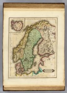
Denmark, Sweden, Norway.
1 : 7900000 Tanner, Henry S.
Zweiter Theil der Karte von Europa welcher Dænemark, und Norwegen, Schweden, und Russland enthælt, 2
1 Blatt : 72 x 54 cm F.A. Schrämbl
Seconde partie de la carte d'Europe contenant le Danemark et la Norwege, la Suède et la Russie (a l'exeption de l'Ukraine), 2
1 Blatt : 71 x 53 cm chez l'auteur
Statistikk 42: Døgnets normaltemperatur i Skandinavia, oktober måned
1 : 4000000
Suede, Norvege, Danemark.
1 : 4500000 Brue, Adrien Hubert, 1786-1832
Statistikk 42: Døgnets normaltemperatur i Skandinavia, januar måned
1 : 4000000
Suede, Norvege, et Danemark.
1 : 5900000 Monin, C.V.
Scandinavien bis zur calmarischen Union, 1397.
1 : 6000000 Spruner von Merz, Karl
Sweden, Denmark, Norway
1 : 7500000 Bowen, Frances
Composite: Courones du Nord.
1 : 2600000 L'Isle, Guillaume de, 1675-1726


Scandinavien
Neuer Handatlas über alle Theile der Erde Kiepert, Heinrich Verlag von Dietrich Reimer
Nordeuropa 1867
Nordeuropa Kunz, Andreas ; Röss, Wolf ; Johnen, Bettina ; Moeschl, Joachim Robert
Denmark, Sweden, and Norway.
1 : 7800000 Finley, Anthony
Skandinavien oder Schweden und Norwegen
Schul-Atlas in 36 Karten Völter, Daniel Verlag der J.M. Dannheimer'schen Buchhandlung
[Neuer Atlas der ganzen Erde nach den neuesten Bestimmungen ... : XII.] Schweden, Norwegen und Daenemark
Nach den besten Materialien entworfen von F.W. Streit Leipzig : J.C. Hinrichssche Buchhandlung
Sweden, Denmark, Norway and Finland.
1 : 6400000 Carey, Mathew
Sweden & Norway.
1 : 7480000 Tanner, Henry S.
Nástěnná mapa Evropy

Statistikk 42: Døgnets normaltemperatur i Skandinavia, april måned
1 : 4000000
Nordeuropa 1789
Nordeuropa Kunz, Andreas ; Treiling, Thomas
Sweden and Norway.
1 : 7603200 Lucas, Fielding Jr.
Denmark, Sweden, and Norway.
Lavoisne, M.
Schweden, Norwegen.
1 : 6000000 Andree, Richard
Norsko, Švédsko, Finsko, Estonsko, Lotyšsko a Litva
1 : 7500000 Estonsko Státní nakladatelství