Maps of Metropolitan France

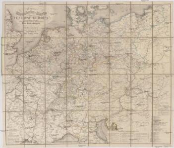
Neueste Eisenbahn-Karte von Central-Europa
Evropa střední Hendschel, U. Carl Jügel
Neueste Post und Reise Karte der wichtigsten und besuchtesten Theile Europa's
1 : 3700000 Evropa střední Kliewer, Friedrich Wilhelm Heymann, Carl Carl Heymann
[Kaart], uit: Reise-Karte von Mittel-Europa : mit Angabe der Bahnstationen und Postverbindungen / entworfen und gezeichnet von M. Hermann
1 : 2800000 titelvariant: Reisekarte von Mittel-Europa; Annotatie: Omslagtitel: Reisekarte von Mittel-Europa Hermann, M. Glogau : Carl Flemming
Carta delle strade ferrate dell'Europa centrale
1 : 2000000 Evropa střední Kirchmayr, C. Colombo Coen
Germania Augustiniana
1 : 2600000 Mollova mapová sbírka Seutter, Matthäus Seutter, Matthäus
Germany.
from A new systeme of the mathematicks: containing I. Arithmetick, as well natural and decimal, as in species, or the principles of algebra. II. Practical geometry, together with the first six books of Euclid's Elements, as also the eleventh and twelfth, symbo
Karte der Eisenbahnen Mittel - Europa ́s ...

Eisenbahnkarte von Mittel Europa
1 : 3375000 Berlín (Německo) Broditzky, Joseph R. v. Waldheim
Eisenbahnkarte von Mittel Europa
1 : 3375000 Berlín (Německo) Broditzky, Joseph R. v. Waldheim
Eisenbahnkarte von Mittel Europa
1 : 3375000 Berlín (Německo) Broditzky, Joseph R. v. Waldheim
Eisenbahnkarte von Mittel Europa
1 : 3375000 Berlín (Německo) Broditzky, Joseph R. v. Waldheim
Eisenbahnkarte von Mittel Europa
1 : 3375000 Berlín (Německo) Broditzky, Joseph R. v. Waldheim
Post und Eisenbahn - Reisekarte Deutschland, Holland, Belgien...

Post- und Eisenbahn-Reisekarte, Deutschland Holland, Belgien, die Schweiz, Italien bis Neapel, der größte Theil von Frankreich, Ungarn, Polen etc
Belgie Hanser, Gustav Serz & C.ie
Post- und Eisenbahn-Reisekarte, Deutschland Holland, Belgien, die Schweiz, Italien bis Neapel, der größte Theil von Frankreich, Ungarn, Polen etc
Belgie Hanser, Gustav Serz
Post- und Eisenbahn-Reisekarte
Belgie Hanser, Gustav Serz & C.ie
Post- und Eisenbahn-Reisekarte, Deutschland Holland, Belgien, die Schweiz, Italien bis Neapel, der größte Theil von Frankreich, Ungarn, Polen etc
Belgie Hanser, Gustav A. Paterno's W.we & Sohn
Post- und Eisenbahn-Reisekarte, Deutschland Holland, Belgien, die Schweiz, Italien bis Neapel, der größte Theil von Frankreich, Ungarn, Polen etc
Belgie Hanser, Gustav A. Paterno's W.we & Sohn
VIII. Charte für die allgemeine Geschichte von Rudolph von Habsburg bis auf Carl V : d.i. von 1273-1519 nach Christus
Entworfen von F.W. Benicken gez. von C.F. Weiland ; in Stein gravirt v. Ant. Falger Weimar : im Verlage des L. Industrie-Comptoirs
Napoleon's Kaiserreich im Jahre 1812
Evropa západní
Post- Reise-Karte durch Deutschland und die angraenzenden Staaten zwischen London und Lublin, Koppenhagen und Mantua
Evropa střední Schmidt, O. F. Schropp, Simon Simon Schropp & Comp.
Post - und Eisenbahn – Reisekarte Deutschland

Special-Karte der Eisenbahn- Post- u[nd] Dampfschiff-Verbindungen Mittel-Europa's
1 : 1240000 Evropa střední Raab, Christian Johann Carl Koch, A. C. Flemming
Special-Karte der Eisenbahn- Post- u[nd] Dampfschiff-Verbindungen Mittel-Europa's
1 : 84000 Evropa střední Raab, Christian Johann Carl Müller, H. C. Flemming
Hendschel's Post u. Reise Karte von Deutschland und den Nachbar-Staaten bis London, Paris, Montpellier, Florenz, Warschau, Kopenhagen &
Evropa střední Hendschel, U. Back, Jean Conr.
Neueste Eisenbahn-Karte von Central-Europa
1 : 1900000 Evropa střední Hendschel, U. Carl Jügel
Neueste Eisenbahn-Karte von Central-Europa
1 : 4000000 Evropa střední Issleib & Rietzschel
Eisenbahn-Übersichtskarte von Mittel-Europa
Evropa R. v. Waldheim
Eisenbahn-Übersichtskarte von Mittel-Europa
Evropa R. v. Waldheim
Eisenbahn-Übersichtskarte von Mittel-Europa
Evropa