Maps of Germany
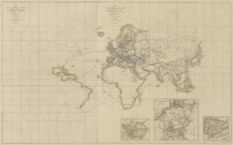
VIII. Charte für die allgemeine Geschichte von Rudolph von Habsburg bis auf Carl V : d.i. von 1273-1519 nach Christus
Entworfen von F.W. Benicken gez. von C.F. Weiland ; in Stein gravirt v. Ant. Falger Weimar : im Verlage des L. Industrie-Comptoirs
[Kaart], uit: Reise-Karte von Mittel-Europa : mit Angabe der Bahnstationen und Postverbindungen / entworfen und gezeichnet von M. Hermann
1 : 2800000 titelvariant: Reisekarte von Mittel-Europa; Annotatie: Omslagtitel: Reisekarte von Mittel-Europa Hermann, M. Glogau : Carl Flemming
Post- Reise-Karte durch Deutschland und die angraenzenden Staaten zwischen London und Lublin, Koppenhagen und Mantua
Evropa střední Schmidt, O. F. Schropp, Simon Simon Schropp & Comp.
Deutschland
Allgemeiner Atlas [Walch, Johannes] im Verlag bei Johannes Walch
Mitteleuropa, Geologische Übersicht
1 : 3500000 Scobel, Albert
Karte der Eisenbahnen Mittel - Europa ́s ...

Neueste Eisenbahn-Karte von Central-Europa
1 : 1900000 Evropa střední Hendschel, U. Carl Jügel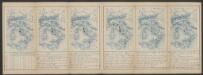
Germania, V. Nova Tabula. [Karte], in: Claud. Ptolemaeus. Geographia lat. cum mappis [...], S. 347.
1 Karte aus Atlas Münster, Sebastian [und Ptolemaeus, Claudius]
Mitteleuropa
1 : 3500000 Evropa střední Köcher
Neueste Post und Reise Karte der wichtigsten und besuchtesten Theile Europa's
1 : 3700000 Evropa střední Kliewer, Friedrich Wilhelm Heymann, Carl Carl Heymann
Neueste Eisenbahn-Karte von Central-Europa
Evropa střední Hendschel, U. Carl Jügel
R.A. Schulz's neue praktische Reise-Karte mit Angabe der Distanzen
Evropa střední Schulz, R. A. Biller, Dominik Artaria & Co.
R.A. Schulz's neue praktische Reise-Karte mit Angabe der Distanzen
Evropa střední Schulz, R. A. Artaria & Co.
Übersicht der Schnellpost und Eilwagen, ... Deutschland

Deutschland
mapa VKOL Petermann, August Justus Perthes
Deutschland
mapa VKOL Petermann, August Justus Perthes
Fluss- u. Gebirgs-Karte, Mittel-Europa.
1 : 4500000 Flemming, Carl
Reise-Karte von Mittel-Europa : mit Angabe der Bahnstationen und Postverbindungen / nach den neuesten Quellen entw. u. gezeichnet. von M. Hermann
1 : 2800000 Annotatie: Bijlage bij: J.C. König und Erhardt's Tages-Notizbuch Hermann, M. [S.l. : s.n.] / (Glogau : Flemming)
Deutsches Reich. Niederlande, Belgien & Schweiz
Adolf Stieler's Handatlas über alle Theile der Erde und über das Weltgebäude Stieler, Adolf Justus Perthes
Hendschel's Post u. Reise Karte von Deutschland und den Nachbar-Staaten bis London, Paris, Montpellier, Florenz, Warschau, Kopenhagen &
Evropa střední Hendschel, U. Back, Jean Conr.
R.A. Schulz's neue praktische Reise-Karte mit Angabe der Distanzen
Anglie Schulz, R. A. Biller, Dominik Artaria
Special-Karte der Eisenbahnen Deutschlands und der angrenzenden Länder
1 : 2000000 Haeberlin, R. Ramdohr
Geognostische Übersichts-Karte von Deutschland, Frankreich, England und den angrenzenden Laendern
Francie Buch, Leopold von Dechen, Heinrich von bei Simon Schropp et Comp.
Germany.
from A new systeme of the mathematicks: containing I. Arithmetick, as well natural and decimal, as in species, or the principles of algebra. II. Practical geometry, together with the first six books of Euclid's Elements, as also the eleventh and twelfth, symbo
Tabula Moderna Germanie [Karte], in: Claudii Ptolemei viri Alexandrini mathematice discipline philosophi doctissimi geographie opus [...], S. 245.
1 Karte aus Atlas Waldseemüller, Martin [und Ptolemaeus, Claudius] Übelin, Georg
Special-Karte der Eisenbahn- Post- u[nd] Dampfschiff-Verbindungen Mittel-Europa's
1 : 1240000 Evropa střední Raab, Christian Johann Carl Koch, A. C. Flemming
Special-Karte der Eisenbahn- Post- u[nd] Dampfschiff-Verbindungen Mittel-Europa's
1 : 84000 Evropa střední Raab, Christian Johann Carl Müller, H. C. Flemming
Deutschland
E. von Sydow's Schul-Atlas in sechs und dreissig Karten Sydow, Emil von bei Justus Perthes
Germany.
from Carey's general atlas, improved and enlarged : being a collection of maps of the world and quarters, their principal empires, kingdoms, &c.