Maps of Italy

Post- und Eisenbahn-Reisekarte, Deutschland Holland, Belgien, die Schweiz, Italien bis Neapel, der größte Theil von Frankreich, Ungarn, Polen etc
Belgie Hanser, Gustav Serz & C.ie
Post- und Eisenbahn-Reisekarte, Deutschland Holland, Belgien, die Schweiz, Italien bis Neapel, der größte Theil von Frankreich, Ungarn, Polen etc
Belgie Hanser, Gustav Serz
Post- und Eisenbahn-Reisekarte
Belgie Hanser, Gustav Serz & C.ie
Post- und Eisenbahn-Reisekarte, Deutschland Holland, Belgien, die Schweiz, Italien bis Neapel, der größte Theil von Frankreich, Ungarn, Polen etc
Belgie Hanser, Gustav A. Paterno's W.we & Sohn
Post- und Eisenbahn-Reisekarte, Deutschland Holland, Belgien, die Schweiz, Italien bis Neapel, der größte Theil von Frankreich, Ungarn, Polen etc
Belgie Hanser, Gustav A. Paterno's W.we & Sohn
Neueste Post und Reise Karte der wichtigsten und besuchtesten Theile Europa's
1 : 3700000 Evropa střední Kliewer, Friedrich Wilhelm Heymann, Carl Carl Heymann
Post - und Eisenbahn – Reisekarte Deutschland

Völkerkarte von Mitteleuropa
1 : 9000000 Mitteleuropa Ethnische Gruppe
Post und Eisenbahn - Reisekarte Deutschland, Holland, Belgien...

Imperivm Romano-Germanicvm sub exitum Caroli VI Austriaci.
1 : 11000000 Mollova mapová sbírka Homann, Johann Baptist Homann, Johann Baptista - dědici
Volksdichtekarte von Mitteleuropa
1 : 9000000 Mitteleuropa Bevölkerungsdichte
Neueste Eisenbahn-Karte von Central-Europa
Evropa střední Hendschel, U. Carl Jügel
Post roads Germany, Hungary.
1 : 2500000 Robert Laurie & James Whittle
Imperivm Francicvm vel Romano-Germanicvm svb Ottone I. & Conrado II.
1 : 11000000 Mollova mapová sbírka Homann, Johann Baptist Homann, Johann Baptista - dědici
Germania Augustiniana
1 : 2600000 Mollova mapová sbírka Seutter, Matthäus Seutter, Matthäus
Carta delle strade ferrate dell'Europa centrale
1 : 2000000 Evropa střední Kirchmayr, C. Colombo Coen
Karte der Eisenbahnen Mittel-Europa's
1 : 1850000 Evropa střední Müller, H. C. Flemming
Napoleon's Kaiserreich im Jahre 1812
Evropa západní
Germany.
from A new systeme of the mathematicks: containing I. Arithmetick, as well natural and decimal, as in species, or the principles of algebra. II. Practical geometry, together with the first six books of Euclid's Elements, as also the eleventh and twelfth, symbo
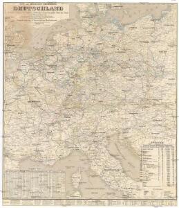
Geogr.-physik.-statist. Karte von Deutschland mit Einschluss von ganz Oesterreich, Belgien, den Niederlanden, der Schweiz, Italien und einem Theile von Frankreich, England, Russland und der Türkei
1 : 4110000 Evropa střední a východní Haurand Theobald Grieben
Imperivm Francicvm vel Romanvm Occidentale Posterivs sub ipso Carolo Magno
1 : 28000000 Mollova mapová sbírka Homann, Johann Baptist Homann, Johann Baptista - dědici
Karte der Heilquellen und Kurorte von Mittel - Europa

Politische Übersicht von Central-Europa
Mitteleuropa
VIII. Charte für die allgemeine Geschichte von Rudolph von Habsburg bis auf Carl V : d.i. von 1273-1519 nach Christus
Entworfen von F.W. Benicken gez. von C.F. Weiland ; in Stein gravirt v. Ant. Falger Weimar : im Verlage des L. Industrie-Comptoirs
Neue Ausgabe von Schulz's praktischer Reise-Karte mit Angabe der Distanzen und Eisenbahnen
Evropa střední Schulz, R. A. Artaria & Co.
Sbírka map a diagramů použitých na mírových konferencích v Paříži v letech 1919 - 1920

Neueste Eisenbahn-Karte von Central-Europa
1 : 4000000 Evropa střední Issleib & Rietzschel
Mitteleuropa
1 : 8000000 Evropa střední Kocen, Blaž Eduard Hölzel