Maps of Metropolitan France

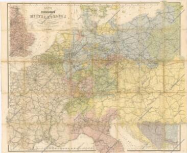
Karte der Eisenbahnen Mittel - Europa ́s ...
Mitteleuropa, Geologische Übersicht
1 : 3500000 Scobel, Albert
Deutschland, Niederlande, Belgien und Schweiz
Schul-Atlas über alle Theile der Erde nach dem neuesten Zustande, und über das Weltgebäude Stieler, Adolf Justus Perthes
Special-Karte der Eisenbahnen Deutschlands und der angrenzenden Länder
1 : 2000000 Haeberlin, R. Ramdohr
Eisenbahn-Übersichtskarte von Mittel-Europa
Evropa R. v. Waldheim
Eisenbahn-Übersichtskarte von Mittel-Europa
Evropa R. v. Waldheim
Eisenbahn-Übersichtskarte von Mittel-Europa
Evropa
Eisenbahn-Übersichtskarte von Mittel-Europa
Evropa R. v. Waldheim
Eisenbahn und Telegraphen-Karte von Europa
Evropa Kastner, Leopold Hacker, Ant. Mechitharisten-Buchdruckerei
Eisenbahn und Telegraphen-Karte von Europa
Evropa Kastner, Leopold Hacker, A.
Post- Reise-Karte durch Deutschland und die angraenzenden Staaten zwischen London und Lublin, Koppenhagen und Mantua
Evropa střední Schmidt, O. F. Schropp, Simon Simon Schropp & Comp.
Deutschland
E. von Sydow's Schul-Atlas in sechs und dreissig Karten Sydow, Emil von bei Justus Perthes
Geognostische Übersichts-Karte von Deutschland, Frankreich, England und den angrenzenden Laendern
Francie Buch, Leopold von Dechen, Heinrich von bei Simon Schropp et Comp.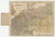
[Kaart], uit: Reise-Karte von Mittel-Europa : mit Angabe der Bahnstationen und Postverbindungen / entworfen und gezeichnet von M. Hermann
1 : 2800000 titelvariant: Reisekarte von Mittel-Europa; Annotatie: Omslagtitel: Reisekarte von Mittel-Europa Hermann, M. Glogau : Carl Flemming
Deutschland
Allgemeiner Atlas [Walch, Johannes] im Verlag bei Johannes Walch
[Střední a západní Evropa]
1 : 2500000 Evropa střední
Neueste Eisenbahn-Karte von Central-Europa
1 : 1900000 Evropa střední Hendschel, U. Carl Jügel
Gallia, Britannia, Germania, Provinciae danuvienses.
1 : 5000000 Kiepert, Heinrich, 1818-1899
Neueste Eisenbahn-Karte von Central-Europa
1 : 4000000 Evropa střední Issleib & Rietzschel
Germania, V. Nova Tabula. [Karte], in: Claud. Ptolemaeus. Geographia lat. cum mappis [...], S. 347.
1 Karte aus Atlas Münster, Sebastian [und Ptolemaeus, Claudius]
2. Pyrenäenfriede 1659
1 : 30000000 Mitteleuropa Pyrenäenfriede
Reise-Karte von Mittel-Europa : mit Angabe der Bahnstationen und Postverbindungen / nach den neuesten Quellen entw. u. gezeichnet. von M. Hermann
1 : 2800000 Annotatie: Bijlage bij: J.C. König und Erhardt's Tages-Notizbuch Hermann, M. [S.l. : s.n.] / (Glogau : Flemming)
Germany.
from A new systeme of the mathematicks: containing I. Arithmetick, as well natural and decimal, as in species, or the principles of algebra. II. Practical geometry, together with the first six books of Euclid's Elements, as also the eleventh and twelfth, symbo
Germany.
from Carey's general atlas, improved and enlarged : being a collection of maps of the world and quarters, their principal empires, kingdoms, &c.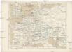
Gallia, Britannia, Rhaetia, Noricum, Pannonia, Germania
Galie
Eisenbahnkarte von Mittel Europa
1 : 3375000 Berlín (Německo) Broditzky, Joseph R. v. Waldheim
Eisenbahnkarte von Mittel Europa
1 : 3375000 Berlín (Německo) Broditzky, Joseph R. v. Waldheim
Eisenbahnkarte von Mittel Europa
1 : 3375000 Berlín (Německo) Broditzky, Joseph R. v. Waldheim
Eisenbahnkarte von Mittel Europa
1 : 3375000 Berlín (Německo) Broditzky, Joseph R. v. Waldheim