Maps of Germany

Hendschel's Post u. Reise Karte von Deutschland und den Nachbar-Staaten bis London, Paris, Montpellier, Florenz, Warschau, Kopenhagen &
Evropa střední Hendschel, U. Back, Jean Conr.
Neueste Eisenbahn-Karte von Central-Europa
1 : 1900000 Evropa střední Hendschel, U. Carl Jügel
[Kaart], uit: Reise-Karte von Mittel-Europa : mit Angabe der Bahnstationen und Postverbindungen / entworfen und gezeichnet von M. Hermann
1 : 2800000 titelvariant: Reisekarte von Mittel-Europa; Annotatie: Omslagtitel: Reisekarte von Mittel-Europa Hermann, M. Glogau : Carl Flemming
Karte der Eisenbahnen Mittel - Europa ́s ...

Special-Karte der Eisenbahnen Deutschlands und der angrenzenden Länder
1 : 2000000 Haeberlin, R. Ramdohr
Deutschland
Allgemeiner Atlas [Walch, Johannes] im Verlag bei Johannes Walch
Germania, V. Nova Tabula. [Karte], in: Claud. Ptolemaeus. Geographia lat. cum mappis [...], S. 347.
1 Karte aus Atlas Münster, Sebastian [und Ptolemaeus, Claudius]
Reise-Karte von Mittel-Europa : mit Angabe der Bahnstationen und Postverbindungen / nach den neuesten Quellen entw. u. gezeichnet. von M. Hermann
1 : 2800000 Annotatie: Bijlage bij: J.C. König und Erhardt's Tages-Notizbuch Hermann, M. [S.l. : s.n.] / (Glogau : Flemming)
Special-Karte der Eisenbahn- Post- u[nd] Dampfschiff-Verbindungen Mittel-Europa's
1 : 1240000 Evropa střední Raab, Christian Johann Carl Koch, A. C. Flemming
Special-Karte der Eisenbahn- Post- u[nd] Dampfschiff-Verbindungen Mittel-Europa's
1 : 84000 Evropa střední Raab, Christian Johann Carl Müller, H. C. Flemming
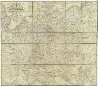
Post- Reise-Karte durch Deutschland und die angraenzenden Staaten zwischen London und Lublin, Koppenhagen und Mantua
Evropa střední Schmidt, O. F. Schropp, Simon Simon Schropp & Comp.
VIII. Charte für die allgemeine Geschichte von Rudolph von Habsburg bis auf Carl V : d.i. von 1273-1519 nach Christus
Entworfen von F.W. Benicken gez. von C.F. Weiland ; in Stein gravirt v. Ant. Falger Weimar : im Verlage des L. Industrie-Comptoirs
Neueste Eisenbahn-Karte von Central-Europa
Evropa střední Hendschel, U. Carl Jügel
Mitteleuropa
1 : 3500000 Evropa střední Köcher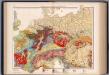
Mitteleuropa, Geologische Übersicht
1 : 3500000 Scobel, Albert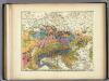
Geologische Karte von Deutschland und den anlieg.
1 : 4600000 Berghaus, Heinrich
Germania, Raetia, Noricum.
1 : 3800000 Menke, Th.
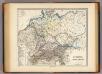
Deutschland
mapa VKOL Petermann, August Justus Perthes
Deutschland
mapa VKOL Petermann, August Justus Perthes
Neueste Post und Reise Karte der wichtigsten und besuchtesten Theile Europa's
1 : 3700000 Evropa střední Kliewer, Friedrich Wilhelm Heymann, Carl Carl Heymann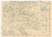
Eisenbahn-Routen-Karte von Mittel-Europa
Evropa střední Ritter, Julius R. v. Waldheim
Fluss- und Bergkarte von Deutschland und den anliegenden Ländern
Handatlas über alle Theile der Erde und über das Weltgebäude Stieler, Adolf Justus Perthes
Fluss und Bergkarte von Deutschland und den anliegenden Ländern
Hand-Atlas über alle Theile der Erde und über das Weltgebäude Stieler, Adolf Justus Perthes
Deutschland
E. von Sydow's Schul-Atlas in sechs und dreissig Karten Sydow, Emil von bei Justus Perthes
[Střední a západní Evropa]
1 : 2500000 Evropa střední
[Fluss- u. Berg-Karte von Deutschland und den anlieg. Ländern]
Hand-Atlas über alle Theile der Erde nach dem neuesten Zustande und über das Weltgebäude Stieler, Adolf bei Justus Perthes
Geologische Karte von Deutschland und anlieg. Ländern

R.A. Schulz's neue praktische Reise-Karte mit Angabe der Distanzen
Evropa střední Schulz, R. A. Biller, Dominik Artaria & Co.