Maps of Metropolitan France

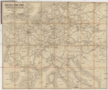
Carta delle strade ferrate dell'Europa centrale
1 : 2000000 Evropa střední Kirchmayr, C. Colombo Coen
[Historisch-geographischer Atlas zu den allgemeinen Geschichtswerken von C. v. Rotteck, Pölitz u. Becker] : Napoleon's Kaiserreich mit Angabe der Hauptbegebenheiten und der Vergrösserungen Frankreichs
von Julius Loewenberg Lithographie v. B. Herder in Freiburg im Breisgau [Freiburg im Breisgau] : [Herder]
Napoleon's Kaiserreich im Jahre 1812
Evropa západní
Germany.
from A new systeme of the mathematicks: containing I. Arithmetick, as well natural and decimal, as in species, or the principles of algebra. II. Practical geometry, together with the first six books of Euclid's Elements, as also the eleventh and twelfth, symbo
Neueste Eisenbahn-Karte von Central-Europa
1 : 4000000 Evropa střední Issleib & Rietzschel
A new map of Germany, Hungary, Transilvania & the Suisse cantons, ...
from The world described, or, A new and correct sett of maps : shewing the kingdoms and states in all the known parts of the earth, with the principal cities, and most considerable towns in the world ... / ... by Herman Moll, geographer ...
Napoleon's Kaiserreich im Jahre 1812
Frankreich, Mitteleuropa, Napoleon I., Frankreich, Kaiser
Neueste Eisenbahn-Karte von Central-Europa
Evropa střední Hendschel, U. Carl Jügel
[Historisch-geographischer Atlas zu den allgemeinen Geschichtswerken von C. v. Rotteck, Pölitz u. Becker] : Deutschland und Frankreich während und nach der Reformation
von Julius Loewenberg Lithographie von B. Herder in Freiburg im Breisgau [Freiburg im Breisgau] : [Herder]
Neueste Post und Reise Karte der wichtigsten und besuchtesten Theile Europa's
1 : 3700000 Evropa střední Kliewer, Friedrich Wilhelm Heymann, Carl Carl Heymann
Central Europe with the Railways.
1 : 3168000 Fullarton, A. & Co.
Gallia, Britannia, Germania, Provinciae danuvienses.
1 : 5000000 Kiepert, Heinrich, 1818-1899
2. Pyrenäenfriede 1659
1 : 30000000 Mitteleuropa Pyrenäenfriede
Karte der Eisenbahnen Mittel - Europa ́s ...

[Historisch-geographischer Atlas zu den allgemeinen Geschichtswerken von C. v. Rotteck, Pölitz u. Becker] : Das Reich Karls des Grossen nach der Theilung seiner Enkel zu Verdun 843
von Julius Loewenberg Lithographie von B. Herder in Freiburg im Breisgau [Freiburg im Breisgau] : [Herder]
Post und Eisenbahn - Reisekarte Deutschland, Holland, Belgien...

Gallia Germania Britannia
Schul-Atlas der alten Welt bei Justus Perthes
Die Republik und das Kaiserthum Frankreich mit seinen Bundes-Staaten.
1 : 5200000 Spruner von Merz, Karl
Rozšíření nejstarší keramiky české v Evropě
Evropa
Imperivm Francicvm vel Romanvm Occidentale Posterivs sub ipso Carolo Magno
1 : 28000000 Mollova mapová sbírka Homann, Johann Baptist Homann, Johann Baptista - dědici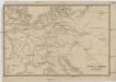
Übersichtskarte des Eisenbahn- und Telegraphen-Verbindungen von Mittel-Europa
1 : 6170000 Evropa střední Mayer, Alexander
Die Reiche der Karolinger.
1 : 5300000 Spruner von Merz, Karl
Eisenbahn-Übersichtskarte von Mittel-Europa
Evropa R. v. Waldheim
Eisenbahn-Übersichtskarte von Mittel-Europa
Evropa R. v. Waldheim
Eisenbahn-Übersichtskarte von Mittel-Europa
Evropa
Eisenbahn-Übersichtskarte von Mittel-Europa
Evropa R. v. Waldheim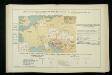
Izvoz robe i vrijednost produkcije većih tvornica 1912. Kralj. Hrvatska i Slavonija
Kroatien Slawonien Export Statistik Industrie
Deutschland, Niederlande, Belgien und Schweiz
Schul-Atlas über alle Theile der Erde nach dem neuesten Zustande, und über das Weltgebäude Stieler, Adolf Justus Perthes
Post- und Eisenbahn-Reisekarte, Deutschland Holland, Belgien, die Schweiz, Italien bis Neapel, der größte Theil von Frankreich, Ungarn, Polen etc
Belgie Hanser, Gustav Serz & C.ie
Post- und Eisenbahn-Reisekarte, Deutschland Holland, Belgien, die Schweiz, Italien bis Neapel, der größte Theil von Frankreich, Ungarn, Polen etc
Belgie Hanser, Gustav Serz
Post- und Eisenbahn-Reisekarte
Belgie Hanser, Gustav Serz & C.ie
Post- und Eisenbahn-Reisekarte, Deutschland Holland, Belgien, die Schweiz, Italien bis Neapel, der größte Theil von Frankreich, Ungarn, Polen etc
Belgie Hanser, Gustav A. Paterno's W.we & Sohn