Maps of Westminster

Insurance Plan of London Western District Vol. A: sheet 35-2
1 : 480 This detailed 1901 plan of London is one of a series of forty-one sheets in an atlas originally produced to aid insurance companies in assessing fire risks. The building footprints, their use (commercial, residential, educational, etc.), the number of floors and the height of the building, as well as construction materials (and thus risk of burning) and special fire hazards (chemicals, kilns, ovens) were documented in order to estimate premiums. Names of individual businesses, property lines, and addresses were also often recorded. Together these maps provide a rich historical shapshot of the commercial activity and urban landscape of towns and cities at the time. The British Library holds a comprehensive collection of fire insurance plans produced by the London-based firm Charles E. Goad Ltd. dating back to 1885. These plans were made for most important towns and cities of the British Isles at the scales of 1:480 (1 inch to 40 feet), as well as many foreign towns at 1:600 (1 inch to 50 feet). Chas E Goad Limited Chas E Goad Limited
Insurance Plan of London Western District Vol. A: sheet 35-1
1 : 480 This detailed 1901 plan of London is one of a series of forty-one sheets in an atlas originally produced to aid insurance companies in assessing fire risks. The building footprints, their use (commercial, residential, educational, etc.), the number of floors and the height of the building, as well as construction materials (and thus risk of burning) and special fire hazards (chemicals, kilns, ovens) were documented in order to estimate premiums. Names of individual businesses, property lines, and addresses were also often recorded. Together these maps provide a rich historical shapshot of the commercial activity and urban landscape of towns and cities at the time. The British Library holds a comprehensive collection of fire insurance plans produced by the London-based firm Charles E. Goad Ltd. dating back to 1885. These plans were made for most important towns and cities of the British Isles at the scales of 1:480 (1 inch to 40 feet), as well as many foreign towns at 1:600 (1 inch to 50 feet). Chas E Goad Limited Chas E Goad Limited
London XI.12 - OS London Town Plan
1 : 1056 Topographic maps Ordnance Survey Ordnance Survey
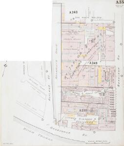
Insurance Plan of London Western District Vol. A: sheet 34
1 : 480 This detailed 1901 plan of London is one of a series of forty-one sheets in an atlas originally produced to aid insurance companies in assessing fire risks. The building footprints, their use (commercial, residential, educational, etc.), the number of floors and the height of the building, as well as construction materials (and thus risk of burning) and special fire hazards (chemicals, kilns, ovens) were documented in order to estimate premiums. Names of individual businesses, property lines, and addresses were also often recorded. Together these maps provide a rich historical shapshot of the commercial activity and urban landscape of towns and cities at the time. The British Library holds a comprehensive collection of fire insurance plans produced by the London-based firm Charles E. Goad Ltd. dating back to 1885. These plans were made for most important towns and cities of the British Isles at the scales of 1:480 (1 inch to 40 feet), as well as many foreign towns at 1:600 (1 inch to 50 feet). Chas E Goad Limited Chas E Goad Limited
PLAN OF an ESTATE SITUATE AT MILLBANK WESTMINSTER belonging to THE MARQUIS OF SALISBURY.
1 : 1440 South of Tothill Fields lies the estate of The Marquis of Salisbury.The estate had about 30 tenants, each of whom are recorded in a reference list in the top right hand corner.This plan has been copied from an original in the possession of the Commission for Woods and Forests. Land use is indicated by various shades of green and stippling.
London (1915- Numbered sheets) IX.1 (includes: Battersea; Chelsea; City Of Westminster) - 25 Inch Map
1 : 2500 Topographic maps Ordnance Survey Ordnance Survey
London (Edition of 1894-96) LXXXVIII (includes: Battersea; Chelsea; City Of Westminster) - 25 Inch Map
1 : 2500 Topographic maps Ordnance Survey Ordnance Survey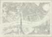
London (First Editions c1850s) LIV (includes: Battersea; Chelsea; City Of Westminster) - 25 Inch Map
1 : 2500 Topographic maps Ordnance Survey Ordnance Survey
Plan of the Esate belonging to Lord Grosvenor
This plan of Pimlico shows the reservoirs of the Chelsea Water Company, the Ranelagh and Scholars Pond sewers and the proposed new buildings and street layout.
Drawn plan of the Manor of Eybury
1 : 3192 This is a 19th-Century copy of a 1614 survey found in the records relating to the Grosvenor Estate. The plan shows the low-lying canals running from Oxford Street to the River Thames that were later used to operate the Chelsea Waterworks. Saunders, G.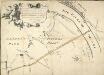
Plan of the Road through Westminster and Tutthill Fields & from St. James's Park Gate by Buckingham House & from Hyde Park Corner to a Bridge that is desired to be made over the Thames 1768 27
This engraved plan shows the road through Tutthill Fields in Westminster leading to the new bridge at Vauxhall.The plan's title features in banner at top left, with compass star at bottom right.The proposed new road stippled and highlighted in colour.
Plan of Lands in the vicinity of the River Thames between Pimlico, Chelsea Hospital and the Penitentiary at Millbank.
1 : 3192 This plan of the parishes of Chelsea and St George, Hanover Square, shows the reservoirs of the Chelsea Water Company and the Ranelagh and Scholars Pond sewers. The note at lower left explains that the drawing is taken from the general plan of the district's sewers made by Peter Potter in 1815. Also shown in the plan are the Ranelagh Gardens, near Chelsea Hospital, which was last licensed as a place of public resort in 1804. Nelson, J.
Map SHEWING THE IMPROVEMENTS Now in Progress at the WEST END OF LONDON
1 : 3840 The title of this plan of Hanover Square and the Parish of St George appears with the publisher's imprint at lower right. Compass star and scale bars are featured at top left. The plan shows Buckingham Palace and additions made in the Regency period to the street plan. The Parish of St. George was established in 1725 and extended from Regent Street (then called Swallow Street) to the Serpentine, and from Oxford Street to include the whole of Mayfair, Belgravia and Pimlico. Ward, E. T.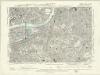
London XI.NW - OS Six-Inch Map
1 : 10560 Topographic maps Ordnance Survey Ordnance Survey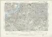
Surrey III.SW - OS Six-Inch Map
1 : 10560 Topographic maps Ordnance Survey Ordnance Survey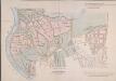
MAP of the GROSVENOR ESTATE (tinted pink) as it was in the Year 1723. with the intended Streets about Grosvenor Square.
1 : 5592 The title of this plan features at top right, with compass star at middle right and explanatory note at bottom right. The boundaries of the St George parish are outlined in red, with the properties in the estate in pink, and parks and open spaces in green. The plan shows the proposed new street plans for Grosvenor Square, but not the Chelsea waterworks,which featured in the original drawing from which this print was produced.
Charles Booth's descriptive map of London poverty 1889
Charles Booth
PLATTE GRONDT DER STADT LONDON MET NIEUW MODEL EN HOE DIE AFGEBRANDT IS
This later edition of the Frederick de Wit's 1666 plan features minor alterations to the title and some additions on the outskirts of the city. The map's title appears along the top, with the key to parish churches (in scrolls) at top left and top right and dividers at top right. An engraving depicting the city on fire is inset at bottom right. Below the plan, a description of the fire is reported in Dutch and French. This edition of the map shows cherubs holding the reference tables and a waterman with oars leaning against the view of the city. Wit, Frederick de
PLATTE GRONDT DER STADT LONDON MET AENWYSINGHE HOE DIE AFGEBRANDT
This map was published in Amsterdam after the great fire of 1666. The title appears along the top of the manuscript, with the key to parish churches (in scrolls) at top left and top right, and dividers at top right. An engraving of the great fire is inset at bottom right, entitled "BRANDENT LONDON". Below the plan, the fire is described in Dutch and French. Wit, Frederick de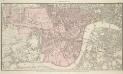
PLAN OF WESTMINSTER. No III
The area shaded red represents the extent of Westminster as defined in the Letters Patent of 3 August 1604. Basire, J.
PLAN OF WESTMINSTER. No II
This map is highlighted to give a retrospective view of the extent of Westminster. Represented in blue is the territory of Westminster according to the Decretal of AD1222 , while the red outline shows the present boundary. The green and yellow outlines indicate manor boundaries. Basire, J.
PLAN OF WESTMINSTER. No 1 [A Plan of the City of Westminster, showing all the Parishes, as well as the Ancient Boundary of Westminster, in the year 951.]
An orange coloured area shows the extent of Westminster according to King Edgar's Charter of AD951. The contemporary boundary of Westminster is shown in red. Basire, J.
Insurance Plan of London South West District Vol. K: Key Plan
1 : 10560 This "key plan" indicates coverage of the Goad 1897 series of fire insurance maps of London that were originally produced to aid insurance companies in assessing fire risks. The building footprints, their use (commercial, residential, educational, etc.), the number of floors and the height of the building, as well as construction materials (and thus risk of burning) and special fire hazards (chemicals, kilns, ovens) were documented in order to estimate premiums. Names of individual businesses, property lines, and addresses were also often recorded. Together these maps provide a rich historical shapshot of the commercial activity and urban landscape of towns and cities at the time. The British Library holds a comprehensive collection of fire insurance plans produced by the London-based firm Charles E. Goad Ltd. dating back to 1885. These plans were made for most important towns and cities of the British Isles at the scales of 1:480 (1 inch to 40 feet), as well as many foreign towns at 1:600 (1 inch to 50 feet). Chas E Goad Limited Chas E Goad Limited
Plan of the city and suburbs of London as fortified by Order of Parliament in the years 1642 and 1643

London SW.
1 : 15840 Stanford, Edward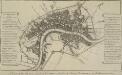
A PLAN of the City and Suburbs of LONDON as fortified by Order of Parliament in the Years 1642 and 1643.
This is a retrospective plan of London showing the defences for the civil war, established after an Act of Parliament in 1642. These built to protect the city from attacks by Charles I and his 15,000 Royalist troops. Here all 23 forts are shown, linked by eighteen miles of ramparts. The Royalists did not attempt to enter London as the King made a tactical withdrawal. Fort 6 was the first to be built, with a commanding prospect of Finsbury Fields. Vertue, G.
Thames and Metropolis Improvement plan
Martin, John
A Plan of LONDON and WESTMINSTER, shewing the Forts erected by order of the Parliament in 1643, and the Desolation by the Fire in 1666
This is a retrospective plan of London, showing the1643 defences for the civil war and the area destroyed by the Great Fire. These defences were built to protect the city from attacks by Charles I and his 15,000 Royalist troops. Here all 23 forts are shown, linked by eighteen miles of ramparts. The Royalists never attempted to enter London because the King made a tactical withdrawal.
LONDINI ANGLIAE REGNI METROPOLIS 70
The title of this map of London, Westminster and Southwark appears along the top. Figures of cherubs are depicted at top left facing the reference table at top right. The royal and city arms are illustrated at the foot of the plate, with a key to places in Southwark and compass rose at lower left, facing the portraits of King William III and Queen Mary at bottom right. The panorama of the city which features in the panel below the plan is based on Matthaeus Merian’s view published in "Theatrum Europeum" in 1720. Joannes de Ram had already published an identical map of the city. His name was removed from the plan when French mapmaker, engraver and publisher Jacques de la Feuille married de Ram’s widow and took over his publishing business. Feuille, Jacques de la