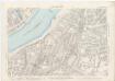
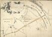
Maps of Westminster
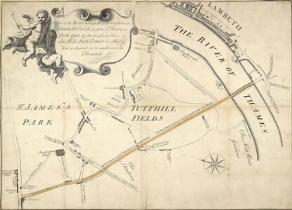
Plan of the Road through Westminster and Tutthill Fields & from St. James's Park Gate by Buckingham House & from Hyde Park Corner to a Bridge that is desired to be made over the Thames 1768 27
This engraved plan shows the road through Tutthill Fields in Westminster leading to the new bridge at Vauxhall.The plan's title features in banner at top left, with compass star at bottom right.The proposed new road stippled and highlighted in colour.
Map SHEWING THE IMPROVEMENTS Now in Progress at the WEST END OF LONDON
1 : 3840 The title of this plan of Hanover Square and the Parish of St George appears with the publisher's imprint at lower right. Compass star and scale bars are featured at top left. The plan shows Buckingham Palace and additions made in the Regency period to the street plan. The Parish of St. George was established in 1725 and extended from Regent Street (then called Swallow Street) to the Serpentine, and from Oxford Street to include the whole of Mayfair, Belgravia and Pimlico. Ward, E. T.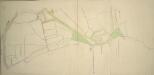
Drawn plan of the Manor of Eybury
1 : 3192 This is a 19th-Century copy of a 1614 survey found in the records relating to the Grosvenor Estate. The plan shows the low-lying canals running from Oxford Street to the River Thames that were later used to operate the Chelsea Waterworks. Saunders, G.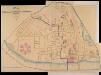
A PLAN of the Streets in the united Parishes of ST. MARGARET & ST. JOHN THE EVANGELIST, Westminster. From a Survey made by I.H. Taylor. No. 22 PARLIAMENT STREET 1828.
Plan of the parishes of St Margaret's, outlined in blue line, and St James', delineated in pink, Westminster. A thin red line shows the boundary of the Tothill Fields District. The large 6-petal structure depicted at lower left is Millbank Penitentiary, built in response to requests for prison reform and finally completed in 1821. Taylor, J. H.
Plan of the Esate belonging to Lord Grosvenor
This plan of Pimlico shows the reservoirs of the Chelsea Water Company, the Ranelagh and Scholars Pond sewers and the proposed new buildings and street layout.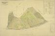
PLAN OF an ESTATE SITUATE AT MILLBANK WESTMINSTER belonging to THE MARQUIS OF SALISBURY.
1 : 1440 South of Tothill Fields lies the estate of The Marquis of Salisbury.The estate had about 30 tenants, each of whom are recorded in a reference list in the top right hand corner.This plan has been copied from an original in the possession of the Commission for Woods and Forests. Land use is indicated by various shades of green and stippling.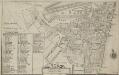
Plan of the Parish of St. Margaret, Westminster From Lea & Morden's Map
1 : 6336 The Abbey, Manchester House and the parish church are shown in elevation. The Decoy in St James' Park is shown. Robert Lea
London (1915- Numbered sheets) V.13 (includes: City Of Westminster) - 25 Inch Map
1 : 2500 Topographic maps Ordnance Survey Ordnance Survey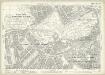
London (Edition of 1894-96) LXXV (includes: City Of Westminster) - 25 Inch Map
1 : 2500 Topographic maps Ordnance Survey Ordnance Survey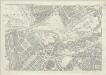
London (First Editions c1850s) XLIII (includes: City Of Westminster) - 25 Inch Map
1 : 2500 Topographic maps Ordnance Survey Ordnance Survey
Drawn plan of the Goring Estate] 3
This is a copy by Crace of a plam of the Goring Estate as it was in 1640. The drawing shows the site in Mulberry Garden Fields where Buckingham Palace was built. Crace, Frederick
Sketch of the Procession Usually Observed in the Coronation of our KINGS & QUEENS together with a PLAN pointing out Several new Paths and their Parts Adjacent
A sketch of individuals and their order in the coronation procession is featured at the top of the page.60 years as king, George III's was the second longest reign in British history. He was third Hanoverian monarch, but the first to be born in England and use English as his first language. His reign was curtailed by periodic bouts of mental instability,which many contemporary commentators ascribed to the strain of the American conflict,but was more likely caused by the hereditary physical disorder called porphyria. He was a cultured monarch who donated to the nation a royal collection of books as the nucleus of a national library, now held in the King's Tower;in the British Library.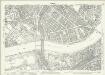
London (1915- Numbered sheets) IX.1 (includes: Battersea; Chelsea; City Of Westminster) - 25 Inch Map
1 : 2500 Topographic maps Ordnance Survey Ordnance Survey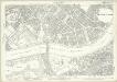
London (Edition of 1894-96) LXXXVIII (includes: Battersea; Chelsea; City Of Westminster) - 25 Inch Map
1 : 2500 Topographic maps Ordnance Survey Ordnance Survey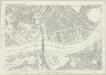
London (First Editions c1850s) LIV (includes: Battersea; Chelsea; City Of Westminster) - 25 Inch Map
1 : 2500 Topographic maps Ordnance Survey Ordnance Survey
A MAPP of the Parish of St MARGARETS Westminster taken from the last Survey with Corrections 7A
1 : 3692 This is John Strype's first edition of Stow's survey. John Stow was a retired sailor who dedicated his retirement to gathering information from records and residents of the Georgian city.The survey extended to include London and Westminster in their entirety, capturing London between Restoration and 18th-century developments.The land on Mill Bank is denoted "Marshy Ground". Renowned for its unhealthy damp atmosphere,it would become the site of the infamous Millbank Penitentiary, and later Tate Britain. Above this a "New Church" is in the process of completion. This would become St John's. Although the survey proved popular, Stow died in poverty at the age of 80, having been granted licence to beg by James I. Stow, John
A MAPP of the Parish of St MARGARETS Westminster taken from the last Survey with Corrections 7 B
This is John Strype's second edition of Stow's survey, published "due to Act of Parliament". This is a reference to the Copyright Act just passed in an effort to stop unauthorised copying of maps. John Stow was a retired sailor who dedicated his retirement to gathering information from records and residents of the Georgian city. The survey extended to include London and Westminster in their entirety, capturing London between Restoration and 18th-century developments. The land on Mill Bank is denoted "Marshy Ground". Renowned for its unhealthy damp atmosphere, it would become the site of the infamous Millbank Penitentiary, and later Tate Britain. Above this a "New Church" sin the process of completion. This would become St John's. Although the survey proved popular, Stow died in poverty at the age of 80,having been granted licence to beg by James I. Stow, John
An exact Survey of the City's of London Westminster, ye Borough of Southwark and the country near ten miles round; begun in 1741 and ended in 1745, by J. Rocque; and engrav'd by R. Parr, 1746.
John Rocque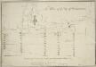
The Plan of ye City of Westminster [showing five locations proposed for the placing of a new bridge]
1 : 3600 Due to the growth of the area in the 18th century, a bridge at Westminster became necessary.This plan shows suggested locations for the building of a bridge. The five locations proposed are: "A", the Horse Ferry on Millbank; "B", College Street or the Slaughter House; "C", the wool stable opposite New Place Yard; "D", Stephen's Alley; "E", Whitehall. There are evident concerns about the Whitehall location being too near the 'elbow' of the river. Cole, B.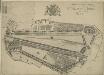
le Palais et Park de St. James. St James Palace and Park
St James's Palace was built by Henry VIII on the site of St James's Hospital, Westminster. It became the principal royal residence in London, after the destruction by fire of Whitehall Palace in 1698. This bird's-eye view shows in detail the palace and grounds, the elevation of the building and the layout of the ornamental gardens. The Admiralty Office is shown on the boundaries of the palace grounds. Kip, J.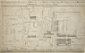
A PLAN of the Lower Parts of the Parishes of ST Margaret and ST JOHN the EVANGELIST, WESTMINSTER, from the HORSE FERRY to WHITEHALL, taken from an ACTUAL SURVEY
1 : 2286 This map shows developments around Westminster Abbey and on the bank of the Thames. Lediard, T.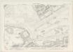
London VII.82 - OS London Town Plan
1 : 1056 Topographic maps Ordnance Survey Ordnance Survey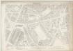
London VII.92 - OS London Town Plan
1 : 1056 Topographic maps Ordnance Survey Ordnance Survey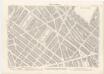
London XI.2 - OS London Town Plan
1 : 1056 Topographic maps Ordnance Survey Ordnance Survey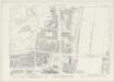
London VII.83 - OS London Town Plan
1 : 1056 Topographic maps Ordnance Survey Ordnance Survey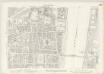
London VII.93 - OS London Town Plan
1 : 1056 Topographic maps Ordnance Survey Ordnance Survey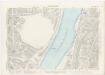
London XI.3 - OS London Town Plan
1 : 1056 Topographic maps Ordnance Survey Ordnance Survey
Drawn plan of the Goring Estate] 3
This is a copy made by Crace in the 19th Century of the Goring Estate in 1675. This is the site on which Buckingham Palace was built.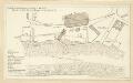
Schetch for the Situation of a Palace at Whitehall the better to Settle that of a Bridge and of a Road to it
Plan of a proposed new palace at Whitehall with key down the left side of the plate.