Maps of Westminster

Plan of the Esate belonging to Lord Grosvenor
This plan of Pimlico shows the reservoirs of the Chelsea Water Company, the Ranelagh and Scholars Pond sewers and the proposed new buildings and street layout.
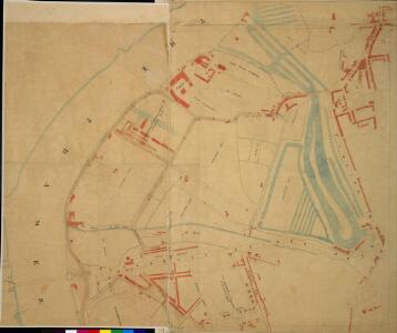
Plan of Lands in the vicinity of the River Thames between Pimlico, Chelsea Hospital and the Penitentiary at Millbank.
1 : 3192 This plan of the parishes of Chelsea and St George, Hanover Square, shows the reservoirs of the Chelsea Water Company and the Ranelagh and Scholars Pond sewers. The note at lower left explains that the drawing is taken from the general plan of the district's sewers made by Peter Potter in 1815. Also shown in the plan are the Ranelagh Gardens, near Chelsea Hospital, which was last licensed as a place of public resort in 1804. Nelson, J.
London (1915- Numbered sheets) IX.1 (includes: Battersea; Chelsea; City Of Westminster) - 25 Inch Map
1 : 2500 Topographic maps Ordnance Survey Ordnance Survey
London (Edition of 1894-96) LXXXVIII (includes: Battersea; Chelsea; City Of Westminster) - 25 Inch Map
1 : 2500 Topographic maps Ordnance Survey Ordnance Survey
London (First Editions c1850s) LIV (includes: Battersea; Chelsea; City Of Westminster) - 25 Inch Map
1 : 2500 Topographic maps Ordnance Survey Ordnance Survey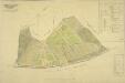
PLAN OF an ESTATE SITUATE AT MILLBANK WESTMINSTER belonging to THE MARQUIS OF SALISBURY.
1 : 1440 South of Tothill Fields lies the estate of The Marquis of Salisbury.The estate had about 30 tenants, each of whom are recorded in a reference list in the top right hand corner.This plan has been copied from an original in the possession of the Commission for Woods and Forests. Land use is indicated by various shades of green and stippling.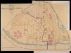
A PLAN of the Streets in the united Parishes of ST. MARGARET & ST. JOHN THE EVANGELIST, Westminster. From a Survey made by I.H. Taylor. No. 22 PARLIAMENT STREET 1828.
Plan of the parishes of St Margaret's, outlined in blue line, and St James', delineated in pink, Westminster. A thin red line shows the boundary of the Tothill Fields District. The large 6-petal structure depicted at lower left is Millbank Penitentiary, built in response to requests for prison reform and finally completed in 1821. Taylor, J. H.
Plan of the Parish of St. Margaret, Westminster From Lea & Morden's Map
1 : 6336 The Abbey, Manchester House and the parish church are shown in elevation. The Decoy in St James' Park is shown. Robert Lea
London VII.92 - OS London Town Plan
1 : 1056 Topographic maps Ordnance Survey Ordnance Survey
London XI.2 - OS London Town Plan
1 : 1056 Topographic maps Ordnance Survey Ordnance Survey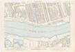
London XI.12 - OS London Town Plan
1 : 1056 Topographic maps Ordnance Survey Ordnance Survey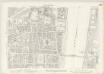
London VII.93 - OS London Town Plan
1 : 1056 Topographic maps Ordnance Survey Ordnance Survey
London XI.3 - OS London Town Plan
1 : 1056 Topographic maps Ordnance Survey Ordnance Survey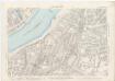
London XI.13 - OS London Town Plan
1 : 1056 Topographic maps Ordnance Survey Ordnance Survey
A MAPP of the Parish of St MARGARETS Westminster taken from the last Survey with Corrections 7 B
This is John Strype's second edition of Stow's survey, published "due to Act of Parliament". This is a reference to the Copyright Act just passed in an effort to stop unauthorised copying of maps. John Stow was a retired sailor who dedicated his retirement to gathering information from records and residents of the Georgian city. The survey extended to include London and Westminster in their entirety, capturing London between Restoration and 18th-century developments. The land on Mill Bank is denoted "Marshy Ground". Renowned for its unhealthy damp atmosphere, it would become the site of the infamous Millbank Penitentiary, and later Tate Britain. Above this a "New Church" sin the process of completion. This would become St John's. Although the survey proved popular, Stow died in poverty at the age of 80,having been granted licence to beg by James I. Stow, John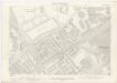
London XI.22 - OS London Town Plan
1 : 1056 Topographic maps Ordnance Survey Ordnance Survey
London XI.11 - OS London Town Plan
1 : 1056 Topographic maps Ordnance Survey Ordnance Survey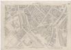
London XI.1 - OS London Town Plan
1 : 1056 Topographic maps Ordnance Survey Ordnance Survey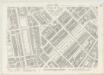
London VII.91 - OS London Town Plan
1 : 1056 Topographic maps Ordnance Survey Ordnance Survey
Insurance Plan of London South West District Vol. K: sheet 5-2
1 : 480 This detailed 1897 plan of London is one of a series of seven sheets in an atlas originally produced to aid insurance companies in assessing fire risks. The building footprints, their use (commercial, residential, educational, etc.), the number of floors and the height of the building, as well as construction materials (and thus risk of burning) and special fire hazards (chemicals, kilns, ovens) were documented in order to estimate premiums. Names of individual businesses, property lines, and addresses were also often recorded. Together these maps provide a rich historical shapshot of the commercial activity and urban landscape of towns and cities at the time. The British Library holds a comprehensive collection of fire insurance plans produced by the London-based firm Charles E. Goad Ltd. dating back to 1885. These plans were made for most important towns and cities of the British Isles at the scales of 1:480 (1 inch to 40 feet), as well as many foreign towns at 1:600 (1 inch to 50 feet). Chas E Goad Limited Chas E Goad Limited
Insurance Plan of London Western District Vol. A: sheet 36-1
1 : 480 This detailed 1901 plan of London is one of a series of forty-one sheets in an atlas originally produced to aid insurance companies in assessing fire risks. The building footprints, their use (commercial, residential, educational, etc.), the number of floors and the height of the building, as well as construction materials (and thus risk of burning) and special fire hazards (chemicals, kilns, ovens) were documented in order to estimate premiums. Names of individual businesses, property lines, and addresses were also often recorded. Together these maps provide a rich historical shapshot of the commercial activity and urban landscape of towns and cities at the time. The British Library holds a comprehensive collection of fire insurance plans produced by the London-based firm Charles E. Goad Ltd. dating back to 1885. These plans were made for most important towns and cities of the British Isles at the scales of 1:480 (1 inch to 40 feet), as well as many foreign towns at 1:600 (1 inch to 50 feet). Chas E Goad Limited Chas E Goad Limited
Insurance Plan of London Western District Vol. A: sheet 11-1
1 : 480 This detailed 1901 plan of London is one of a series of forty-one sheets in an atlas originally produced to aid insurance companies in assessing fire risks. The building footprints, their use (commercial, residential, educational, etc.), the number of floors and the height of the building, as well as construction materials (and thus risk of burning) and special fire hazards (chemicals, kilns, ovens) were documented in order to estimate premiums. Names of individual businesses, property lines, and addresses were also often recorded. Together these maps provide a rich historical shapshot of the commercial activity and urban landscape of towns and cities at the time. The British Library holds a comprehensive collection of fire insurance plans produced by the London-based firm Charles E. Goad Ltd. dating back to 1885. These plans were made for most important towns and cities of the British Isles at the scales of 1:480 (1 inch to 40 feet), as well as many foreign towns at 1:600 (1 inch to 50 feet). Chas E Goad Limited Chas E Goad Limited
Insurance Plan of London Western District Vol. A: sheet 37
1 : 480 This detailed 1901 plan of London is one of a series of forty-one sheets in an atlas originally produced to aid insurance companies in assessing fire risks. The building footprints, their use (commercial, residential, educational, etc.), the number of floors and the height of the building, as well as construction materials (and thus risk of burning) and special fire hazards (chemicals, kilns, ovens) were documented in order to estimate premiums. Names of individual businesses, property lines, and addresses were also often recorded. Together these maps provide a rich historical shapshot of the commercial activity and urban landscape of towns and cities at the time. The British Library holds a comprehensive collection of fire insurance plans produced by the London-based firm Charles E. Goad Ltd. dating back to 1885. These plans were made for most important towns and cities of the British Isles at the scales of 1:480 (1 inch to 40 feet), as well as many foreign towns at 1:600 (1 inch to 50 feet). Chas E Goad Limited Chas E Goad Limited
Insurance Plan of London Western District Vol. A: sheet 4
1 : 480 This detailed 1901 plan of London is one of a series of forty-one sheets in an atlas originally produced to aid insurance companies in assessing fire risks. The building footprints, their use (commercial, residential, educational, etc.), the number of floors and the height of the building, as well as construction materials (and thus risk of burning) and special fire hazards (chemicals, kilns, ovens) were documented in order to estimate premiums. Names of individual businesses, property lines, and addresses were also often recorded. Together these maps provide a rich historical shapshot of the commercial activity and urban landscape of towns and cities at the time. The British Library holds a comprehensive collection of fire insurance plans produced by the London-based firm Charles E. Goad Ltd. dating back to 1885. These plans were made for most important towns and cities of the British Isles at the scales of 1:480 (1 inch to 40 feet), as well as many foreign towns at 1:600 (1 inch to 50 feet). Chas E Goad Limited Chas E Goad Limited
Insurance Plan of London Western District Vol. A: sheet 34
1 : 480 This detailed 1901 plan of London is one of a series of forty-one sheets in an atlas originally produced to aid insurance companies in assessing fire risks. The building footprints, their use (commercial, residential, educational, etc.), the number of floors and the height of the building, as well as construction materials (and thus risk of burning) and special fire hazards (chemicals, kilns, ovens) were documented in order to estimate premiums. Names of individual businesses, property lines, and addresses were also often recorded. Together these maps provide a rich historical shapshot of the commercial activity and urban landscape of towns and cities at the time. The British Library holds a comprehensive collection of fire insurance plans produced by the London-based firm Charles E. Goad Ltd. dating back to 1885. These plans were made for most important towns and cities of the British Isles at the scales of 1:480 (1 inch to 40 feet), as well as many foreign towns at 1:600 (1 inch to 50 feet). Chas E Goad Limited Chas E Goad Limited
Insurance Plan of London South West District Vol. K: sheet 6
1 : 480 This detailed 1897 plan of London is one of a series of seven sheets in an atlas originally produced to aid insurance companies in assessing fire risks. The building footprints, their use (commercial, residential, educational, etc.), the number of floors and the height of the building, as well as construction materials (and thus risk of burning) and special fire hazards (chemicals, kilns, ovens) were documented in order to estimate premiums. Names of individual businesses, property lines, and addresses were also often recorded. Together these maps provide a rich historical shapshot of the commercial activity and urban landscape of towns and cities at the time. The British Library holds a comprehensive collection of fire insurance plans produced by the London-based firm Charles E. Goad Ltd. dating back to 1885. These plans were made for most important towns and cities of the British Isles at the scales of 1:480 (1 inch to 40 feet), as well as many foreign towns at 1:600 (1 inch to 50 feet). Chas E Goad Limited Chas E Goad Limited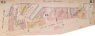
Insurance Plan of London South West District Vol. K: sheet 5-1
1 : 480 This detailed 1897 plan of London is one of a series of seven sheets in an atlas originally produced to aid insurance companies in assessing fire risks. The building footprints, their use (commercial, residential, educational, etc.), the number of floors and the height of the building, as well as construction materials (and thus risk of burning) and special fire hazards (chemicals, kilns, ovens) were documented in order to estimate premiums. Names of individual businesses, property lines, and addresses were also often recorded. Together these maps provide a rich historical shapshot of the commercial activity and urban landscape of towns and cities at the time. The British Library holds a comprehensive collection of fire insurance plans produced by the London-based firm Charles E. Goad Ltd. dating back to 1885. These plans were made for most important towns and cities of the British Isles at the scales of 1:480 (1 inch to 40 feet), as well as many foreign towns at 1:600 (1 inch to 50 feet). Chas E Goad Limited Chas E Goad Limited
Insurance Plan of London Western District Vol. A: sheet 35-2
1 : 480 This detailed 1901 plan of London is one of a series of forty-one sheets in an atlas originally produced to aid insurance companies in assessing fire risks. The building footprints, their use (commercial, residential, educational, etc.), the number of floors and the height of the building, as well as construction materials (and thus risk of burning) and special fire hazards (chemicals, kilns, ovens) were documented in order to estimate premiums. Names of individual businesses, property lines, and addresses were also often recorded. Together these maps provide a rich historical shapshot of the commercial activity and urban landscape of towns and cities at the time. The British Library holds a comprehensive collection of fire insurance plans produced by the London-based firm Charles E. Goad Ltd. dating back to 1885. These plans were made for most important towns and cities of the British Isles at the scales of 1:480 (1 inch to 40 feet), as well as many foreign towns at 1:600 (1 inch to 50 feet). Chas E Goad Limited Chas E Goad Limited
Insurance Plan of London Western District Vol. A: sheet 33-1
1 : 480 This detailed 1901 plan of London is one of a series of forty-one sheets in an atlas originally produced to aid insurance companies in assessing fire risks. The building footprints, their use (commercial, residential, educational, etc.), the number of floors and the height of the building, as well as construction materials (and thus risk of burning) and special fire hazards (chemicals, kilns, ovens) were documented in order to estimate premiums. Names of individual businesses, property lines, and addresses were also often recorded. Together these maps provide a rich historical shapshot of the commercial activity and urban landscape of towns and cities at the time. The British Library holds a comprehensive collection of fire insurance plans produced by the London-based firm Charles E. Goad Ltd. dating back to 1885. These plans were made for most important towns and cities of the British Isles at the scales of 1:480 (1 inch to 40 feet), as well as many foreign towns at 1:600 (1 inch to 50 feet). Chas E Goad Limited Chas E Goad Limited