Maps of Westminster

Map SHEWING THE IMPROVEMENTS Now in Progress at the WEST END OF LONDON
1 : 3840 The title of this plan of Hanover Square and the Parish of St George appears with the publisher's imprint at lower right. Compass star and scale bars are featured at top left. The plan shows Buckingham Palace and additions made in the Regency period to the street plan. The Parish of St. George was established in 1725 and extended from Regent Street (then called Swallow Street) to the Serpentine, and from Oxford Street to include the whole of Mayfair, Belgravia and Pimlico. Ward, E. T.
MAP of the GROSVENOR ESTATE (tinted pink) as it was in the Year 1723. with the intended Streets about Grosvenor Square.
1 : 5592 The title of this plan features at top right, with compass star at middle right and explanatory note at bottom right. The boundaries of the St George parish are outlined in red, with the properties in the estate in pink, and parks and open spaces in green. The plan shows the proposed new street plans for Grosvenor Square, but not the Chelsea waterworks,which featured in the original drawing from which this print was produced.
Drawn plan of the Manor of Eybury
1 : 3192 This is a 19th-Century copy of a 1614 survey found in the records relating to the Grosvenor Estate. The plan shows the low-lying canals running from Oxford Street to the River Thames that were later used to operate the Chelsea Waterworks. Saunders, G.
Plan of the Road through Westminster and Tutthill Fields & from St. James's Park Gate by Buckingham House & from Hyde Park Corner to a Bridge that is desired to be made over the Thames 1768 27
This engraved plan shows the road through Tutthill Fields in Westminster leading to the new bridge at Vauxhall.The plan's title features in banner at top left, with compass star at bottom right.The proposed new road stippled and highlighted in colour.
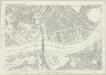
A new and exact plan of the city of London and suburbs thereof, 1
1 Blatt : 60 x 52 cm Henry Overton
Insurance Plan of London: General Key Plan
1 : 4800 This "key plan" indicates coverage of the Goad 1889 series of fire insurance maps of London that were originally produced to aid insurance companies in assessing fire risks. The building footprints, their use (commercial, residential, educational, etc.), the number of floors and the height of the building, as well as construction materials (and thus risk of burning) and special fire hazards (chemicals, kilns, ovens) were documented in order to estimate premiums. Names of individual businesses, property lines, and addresses were also often recorded. Together these maps provide a rich historical shapshot of the commercial activity and urban landscape of towns and cities at the time. The British Library holds a comprehensive collection of fire insurance plans produced by the London-based firm Charles E. Goad Ltd. dating back to 1885. These plans were made for most important towns and cities of the British Isles at the scales of 1:480 (1 inch to 40 feet), as well as many foreign towns at 1:600 (1 inch to 50 feet). Chas E Goad Limited Chas E Goad Limited
A New and Exact Plan of the City of LONDON and Suburbs thereof, With the addition of the New Buildings, Churches &c. to this present Year 1720 (Not extant in any other)
1 : 6336 This map of the West End of London is part of Henry Overton's complete map of London and its suburbs, published in 1720.The title and publisher's imprint appear in cartouche in the centre, with fares of hackney coaches and an overall key at bottom left. The compass rose appears in the river, with parish boundaries outlined in colour. Henry Overton took over his father John's publishing business in 1707 and continued to publish maps from the same address at White Horse near Newgate. Overton, Henry
Drawn plan of the Goring Estate] 3
This is a copy by Crace of a plam of the Goring Estate as it was in 1640. The drawing shows the site in Mulberry Garden Fields where Buckingham Palace was built. Crace, Frederick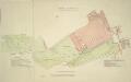
A SURVEY OF THE CONDUITS &c. to WHITEHALL, St.JAMES &c.
1 : 3600 This is a 19th century copy of an original 1718 plan held by the Society of Antiquaries. t details the conduits supplying water to St. James's and Whitehall from Hyde Park. Long
ST. GEORGE'S PARISH, HANOVER SQUARE.
1 : 8448 This plan of the Parish of St George is surrounded by views of St George's church, Knightsbridge chapel, Conduit Street chapel, Chelsea chapel, Audley Street chapel and Berkeley chapel, the whole set within a decorative border. The title and imprint appear at the foot of the plate. The Parish of St George was created in 1725 and covered an area previously in the Parish of St. Martin-in-the-Fields that stretched from Regent Street (then called Swallow Street) to the Serpentine, and from Oxford Street to Mayfair, Belgravia and Pimlico. Bickham, J.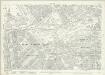
London (1915- Numbered sheets) V.13 (includes: City Of Westminster) - 25 Inch Map
1 : 2500 Topographic maps Ordnance Survey Ordnance Survey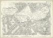
London (Edition of 1894-96) LXXV (includes: City Of Westminster) - 25 Inch Map
1 : 2500 Topographic maps Ordnance Survey Ordnance Survey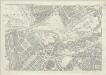
London (First Editions c1850s) XLIII (includes: City Of Westminster) - 25 Inch Map
1 : 2500 Topographic maps Ordnance Survey Ordnance Survey
Plan of Lands in the vicinity of the River Thames between Pimlico, Chelsea Hospital and the Penitentiary at Millbank.
1 : 3192 This plan of the parishes of Chelsea and St George, Hanover Square, shows the reservoirs of the Chelsea Water Company and the Ranelagh and Scholars Pond sewers. The note at lower left explains that the drawing is taken from the general plan of the district's sewers made by Peter Potter in 1815. Also shown in the plan are the Ranelagh Gardens, near Chelsea Hospital, which was last licensed as a place of public resort in 1804. Nelson, J.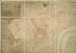
A PLAN OF HIS MAJESTY'S BAYLIWICK OF ST. JAMES IN THE COUNTY OF MIDDLESEX
1 : 2400 This drawn survey of the West of London extends from Knightsbridge to Temple Bar and from Marylebone Gardens to Buckingham Palace. Buildings are indicated in red, open spaces and park land in green and watercourses in blue. Symbols are used to distinguish land use. Gough, William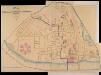
A PLAN of the Streets in the united Parishes of ST. MARGARET & ST. JOHN THE EVANGELIST, Westminster. From a Survey made by I.H. Taylor. No. 22 PARLIAMENT STREET 1828.
Plan of the parishes of St Margaret's, outlined in blue line, and St James', delineated in pink, Westminster. A thin red line shows the boundary of the Tothill Fields District. The large 6-petal structure depicted at lower left is Millbank Penitentiary, built in response to requests for prison reform and finally completed in 1821. Taylor, J. H.
A Copy of Part of a Map of London from Newcourt
This is a copy of part of the Faithorne map. It is an example of a bird's-eye (or 'plan') view. Crace often had copies made of maps if he was unable to procure an original.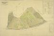
PLAN OF an ESTATE SITUATE AT MILLBANK WESTMINSTER belonging to THE MARQUIS OF SALISBURY.
1 : 1440 South of Tothill Fields lies the estate of The Marquis of Salisbury.The estate had about 30 tenants, each of whom are recorded in a reference list in the top right hand corner.This plan has been copied from an original in the possession of the Commission for Woods and Forests. Land use is indicated by various shades of green and stippling.
Plan of the Esate belonging to Lord Grosvenor
This plan of Pimlico shows the reservoirs of the Chelsea Water Company, the Ranelagh and Scholars Pond sewers and the proposed new buildings and street layout.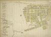
Plan of the Parish of St. George, Hanover Square
The streets of the parish are numbered in red ink for reference, with a key along the left side of the sheet.The Parish of St George was created in 1725 and covered an area previously in the Parish of St. Martin-in-the-Fields that stretched from Regent Street (then called Swallow Street) to the Serpentine, and from Oxford Street to Mayfair, Belgravia and Pimlico.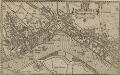
WESTMINSTER
This plan-view of Westminster was published in Norden's 'Speculum Britanniae' in 1593. The title appears at top right below the royal arms, with a compass rose at the foot of the plate. Under different jurisdiction than the City of London, Westminster had developed during the middle ages into a centre of royal administration. Along the Strand are the former residences of the Bishops deposed at the Reformation. By the late 16th Century, these properties were in the hands of the Queen's courtiers, statesmen and other people of influence. Norden, John
Sketch of the Procession Usually Observed in the Coronation of our KINGS & QUEENS together with a PLAN pointing out Several new Paths and their Parts Adjacent
A sketch of individuals and their order in the coronation procession is featured at the top of the page.60 years as king, George III's was the second longest reign in British history. He was third Hanoverian monarch, but the first to be born in England and use English as his first language. His reign was curtailed by periodic bouts of mental instability,which many contemporary commentators ascribed to the strain of the American conflict,but was more likely caused by the hereditary physical disorder called porphyria. He was a cultured monarch who donated to the nation a royal collection of books as the nucleus of a national library, now held in the King's Tower;in the British Library.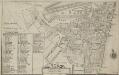
Plan of the Parish of St. Margaret, Westminster From Lea & Morden's Map
1 : 6336 The Abbey, Manchester House and the parish church are shown in elevation. The Decoy in St James' Park is shown. Robert Lea
The PARISH of ST. JAMES'S, Westminster, taken from the last Survey with Corrections 3
1 : 11076 This plan was taken from Strype's first annotated edition of Stow's "Survey of England". The plan's title features in cartouche at the top of the plate, with keys to streets, yards, inns, halls and other landmarks in tables at top left and bottom right.The scale bar is also at bottom right. Additions made by Strype that did not feature in earlier editions of the plan include the housing developments in Soho and neighbouring St Martin's (replacing open fields and an extended table of reference). Blome, Richard
The PARISH of ST. JAMES'S, Westminster, taken from the last Survey with Corrections 2
1 : 11076 This plan is taken from the first edition of Stow's "Survey of England".The plan's title features in a banner at the top centre, with a key to streets, yards, halls, courts and private properties at the top left.Land use and natural features described by symbols and three-dimensional illustrations.St James's Square was laid out in 1662 when Henry Jermyn, Earl of St Albans, obtained a grant of land on the outskirts of London.In 1674, Christopher Wren was appointed architect of the parish church. Blome, Richard
le Palais et Park de St. James. St James Palace and Park
St James's Palace was built by Henry VIII on the site of St James's Hospital, Westminster. It became the principal royal residence in London, after the destruction by fire of Whitehall Palace in 1698. This bird's-eye view shows in detail the palace and grounds, the elevation of the building and the layout of the ornamental gardens. The Admiralty Office is shown on the boundaries of the palace grounds. Kip, J.
A MAPP of the Parish of St MARGARETS Westminster taken from the last Survey with Corrections 7A
1 : 3692 This is John Strype's first edition of Stow's survey. John Stow was a retired sailor who dedicated his retirement to gathering information from records and residents of the Georgian city.The survey extended to include London and Westminster in their entirety, capturing London between Restoration and 18th-century developments.The land on Mill Bank is denoted "Marshy Ground". Renowned for its unhealthy damp atmosphere,it would become the site of the infamous Millbank Penitentiary, and later Tate Britain. Above this a "New Church" is in the process of completion. This would become St John's. Although the survey proved popular, Stow died in poverty at the age of 80, having been granted licence to beg by James I. Stow, John
Plan of a LEASEHOLD ESTATE Situate at Pimlico IN THE COUNTY OF MIDDLESEX belonging to ... 1825
1 : 2400 This is a plan of the leasehold of Earl Grosvenor,later Marquis of Westminster, in Belgrave Square. Earl Grosvenor was granted permission by Parliament to develop the ten acre site in 1826, and commisioned the young architect George Basevi, a pupil of John Soane's, to design the square. Grosvenor's name has been smudged from the title at top right.
Drawn plan of the Goring Estate] 3
This is a copy made by Crace in the 19th Century of the Goring Estate in 1675. This is the site on which Buckingham Palace was built.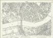
London (1915- Numbered sheets) IX.1 (includes: Battersea; Chelsea; City Of Westminster) - 25 Inch Map
1 : 2500 Topographic maps Ordnance Survey Ordnance Survey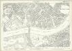
London (Edition of 1894-96) LXXXVIII (includes: Battersea; Chelsea; City Of Westminster) - 25 Inch Map
1 : 2500 Topographic maps Ordnance Survey Ordnance Survey