Maps of Westminster
PLAN OF WESTMINSTER. No II
This map is highlighted to give a retrospective view of the extent of Westminster. Represented in blue is the territory of Westminster according to the Decretal of AD1222 , while the red outline shows the present boundary. The green and yellow outlines indicate manor boundaries. Basire, J.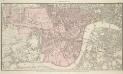
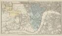
PLAN OF WESTMINSTER. No III
The area shaded red represents the extent of Westminster as defined in the Letters Patent of 3 August 1604. Basire, J.
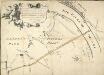
PLAN OF WESTMINSTER. No 1 [A Plan of the City of Westminster, showing all the Parishes, as well as the Ancient Boundary of Westminster, in the year 951.]
An orange coloured area shows the extent of Westminster according to King Edgar's Charter of AD951. The contemporary boundary of Westminster is shown in red. Basire, J.
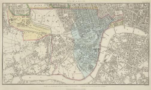
London
Grosser Hand-Atlas über alle Theile der Erde in 170 Karten Meyer, J. Verlag des Bibliographischen Instituts
The London directory, or a new & improved plan of London, Westminster, & Southwark, with the adjacent country, the new buildings, the new roads, and the late alterations by opening of new streets, & widening of others
1 : 15840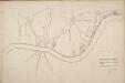
Thames and Metropolis Improvement plan
Martin, John
MAP OF THE WESTERN SIDE OF LONDON, DISTINGUISHING THE ESTATE OF HER MAJESTY'S COMMISSIONERS FOR THE EXHIBITION OF 1851.
1 : 21120 Map of Kensington with title along the top and scale bar below the plan. The site of the Great Exhibiton of 1851 in Hyde Park is highlighted in green. Day & Son
A PLAN of HYDE-PARK with the CITY and LIBERTIES of WESTMINSTER &c. Shewing the several IMPROVEMENTS propos'd
This plan shows renovations in Hyde Park and around Westminster.Two Royal palaces have been planned, in Hyde Park and Green Park. The red lines show an intention to regularize the street plan, replacing the narrow irregular streets with a gridlike formation. Gwynn, John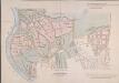
MAP of the GROSVENOR ESTATE (tinted pink) as it was in the Year 1723. with the intended Streets about Grosvenor Square.
1 : 5592 The title of this plan features at top right, with compass star at middle right and explanatory note at bottom right. The boundaries of the St George parish are outlined in red, with the properties in the estate in pink, and parks and open spaces in green. The plan shows the proposed new street plans for Grosvenor Square, but not the Chelsea waterworks,which featured in the original drawing from which this print was produced.
Ordnance Survey of London Skeleto
Ordnance Survey
London VII.SW - OS Six-Inch Map
1 : 10560 Topographic maps Ordnance Survey Ordnance Survey
Charles Booth's descriptive map of London poverty 1889
Charles Booth
Map SHEWING THE IMPROVEMENTS Now in Progress at the WEST END OF LONDON
1 : 3840 The title of this plan of Hanover Square and the Parish of St George appears with the publisher's imprint at lower right. Compass star and scale bars are featured at top left. The plan shows Buckingham Palace and additions made in the Regency period to the street plan. The Parish of St. George was established in 1725 and extended from Regent Street (then called Swallow Street) to the Serpentine, and from Oxford Street to include the whole of Mayfair, Belgravia and Pimlico. Ward, E. T.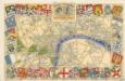
The Royal Wedding picture map of the road

FORD'S ILLUSTRATED MEMORIAL OF THE GRAND INDUSTRIAL EXHIBITION OF ALL NATIONS, HYDE PARK, LONDON 1851
This pictorial map commemorates the Great Exhibition of 1851, conceived by Henry Cole and presided over by Prince Albert. Theexhibition was held in the Crystal Palace. Designed by Joseph Paxton, it showcased exhibits from all over the world, including the largest pearl ever found, a knife with 300 blades, and the Koh-i-Noor diamond. The exhibition was opened by Queen Victoria in May 1851. She remained a frequent visitor, as did the Duke of Wellington. Only main roads in the capital are shown on this map and London locations are marked by small medallions containing scenes. Borders of roundels contain people from "all nations". Queen Victoria and Albert flank a view of the Crystal Palace, which was removed from Hyde Park in 1852andrebuilt at Sydenham. Simpson Ford, William
A New PLAN of the CITY and LIBERTY of WESTMINSTER, Exhibiting all the New Streets & Roads, with the Residences of the Principal Nobility, Public Offices, &c. Not extant in any other Plan.
This map is by Thomas Jeffreys, an exceptional cartographer and publisher whose productions, including maps of North America, are considered to be among the finest of his age. This map shows the new developments in Westminster by use of a colour coding system indicating varying stages of completion. Portman Square (W1), a contemporary development, was begun the year before this map was published. It was built between 1764 and 84 for the landlord Henry William Portman on what was then considered the outskirts of town. Thomas Jeffreys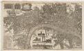
London surveyed, or, a new map of the cities of London and Westminster and the boroguh of Southwark : shewing the several streets and lanes with the most of the alleys & thorough fairs with the additional new buildings to this present year 1742
1 : 5280 Bowles, John, 1701-1779 Printed for John Bowles at the Black Horse in Cornhill
A new and exact plan of the city of London and suburbs thereof, 1
1 Blatt : 60 x 52 cm Henry Overton
A New and Exact Plan of the City of LONDON and Suburbs thereof, With the addition of the New Buildings, Churches &c. to this present Year 1720 (Not extant in any other)
1 : 6336 This map of the West End of London is part of Henry Overton's complete map of London and its suburbs, published in 1720.The title and publisher's imprint appear in cartouche in the centre, with fares of hackney coaches and an overall key at bottom left. The compass rose appears in the river, with parish boundaries outlined in colour. Henry Overton took over his father John's publishing business in 1707 and continued to publish maps from the same address at White Horse near Newgate. Overton, Henry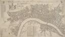
A NEW Mapp of the CITY of LONDON &c. With the Many additional Buildings and New Streets Anno 1720 In a Playne Method for Easy finding any street at first View
This is a later edition of a map first published in 1716. The title appears along the top, with a key to churches at top left, alongside coats of arms representing the City and the twelve Great Livery Companies. The key to individual city wards appears at top right. At bottom left are a compass rose, scale bar and the key to public buildings. Rates of hackney coaches and water ferries appear in a table at bottom centre. The map is similar to Overton’s map of 1706, showing St. Paul's and other prominent buildings pictorially. Taylor, Thomas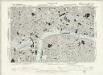
Surrey III.NW - OS Six-Inch Map
1 : 10560 Topographic maps Ordnance Survey Ordnance Survey
NEW and ACCURATE PLAN of the CITY of WESTMINSTER, The DUTCHY of LANCASTER and Places Adjacent
1 : 11520 The title of this map appears in cartouche at top right, with a compass rose at top left. A territory with its own courts and administration, the Duchy of Lancaster was created in 1267 by Edward III for his younger son John. The Duchy was attached to the Crown when Prince Henry of Bolingbroke, the last Duke of Lancaster, became Henry IV in 1399. To this day, the Duchy has retained its own jurisdiction under the Chancellor of the Duchy of Lancaster.The chancellorship is a high governmental position, and sometimes a cabinet poist. Since, for at least the last two centuries, the Chancellor rarely has had any significant duties pertaining to the Duchy's management, he is usually available as a minister without portfolio. Recent Chancellors have included Labour cabinet minister Mo Mowlam.
Vrbium Londini et West-Monasterii nec non suburbii Southwark accurata ichnographia, 1
1 Blatt : 52 x 64 cm Homännische Erben
A NEW and ACCURATE PLAN of the CITY of WESTMINSTER The DUTCHY of LANCASTER and Places Adjacent
John Rocque developed his surveying talent at a young age, making plans of the great houses and gardens of the nobility.This early experience led to him taking up large-scale surveying, producing plans such as this one of Westminster. Here, Tottenham Court and Marylebone are mostly fields but Westminster has grown sufficiently to demand the construction of a new bridge.Westminster Bridge was opened in 1750 and watermen were paid 163;25,000 in compensation as the new bridge made them largely redundant. The Chelsea Water Works Company, shown south of Totthill Fields, was set up to improve water supply to Westminster and "parts adjacent".The Company were the first to introduce slow sand filtration to purify Thames water. Rocque, John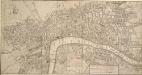
A New and Correct PLAN of LONDON, WESTMINSTER and SOUTHWARK, with several Additional Improvements, not in any former Survey
The title of this map appears in a square table at bottom right with the publisher’s imprint and scale bar below the plan. The writer, poet and dramatist Robert Dodsley and his brother, the print- and book-seller James, were business partners and issued this map from their shop in Pall Mall in 1761. Dodsley, Robert & James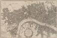
A POCKET MAP of the Cities of LONDON, WESTMINSTER & SOUTHWARK With the Addition of the Buildings to the Present Year
The title of this pocket map of London, Westminster and Southwark appears in cartouche at bottom centre alongside the city arms. A compass star is depicted in the river with a publisher’s imprint (in scroll) at bottom left. An engraver by trade, Thomas Bowles acquired the stock of cartographers Morden & Lea at the beginning of the 18th Century, starting a successful publishing house, the output of which was almost entirely derivative. Bowles' brother, John, was also a print seller and publisher. Their businesses were separate, but the two often worked together. Bowles, Thomas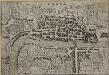
LONDRA
This small Italian etching is one of the earliest surviving maps of the city of London. It appeared in a book by Francesco Velagio entitled 'Raccolta di le piu` illustri et famose citta di tutto il mondo'. Published in Venice around 1595, the book depicts the main Italian and European cities. The map was copied for a fresco in a church in the Italian city of Mantua. Velagio, Francesco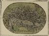
LONDON 20
A miniature map of London and Westminster with title at the foot of the plate and areas outside the built-up area coloured green.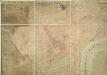
A PLAN OF HIS MAJESTY'S BAYLIWICK OF ST. JAMES IN THE COUNTY OF MIDDLESEX
1 : 2400 This drawn survey of the West of London extends from Knightsbridge to Temple Bar and from Marylebone Gardens to Buckingham Palace. Buildings are indicated in red, open spaces and park land in green and watercourses in blue. Symbols are used to distinguish land use. Gough, William