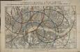
Maps of Westminster

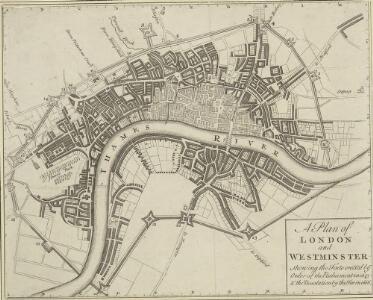
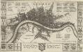
A Plan of LONDON and WESTMINSTER, shewing the Forts erected by order of the Parliament in 1643, and the Desolation by the Fire in 1666
This is a retrospective plan of London, showing the1643 defences for the civil war and the area destroyed by the Great Fire. These defences were built to protect the city from attacks by Charles I and his 15,000 Royalist troops. Here all 23 forts are shown, linked by eighteen miles of ramparts. The Royalists never attempted to enter London because the King made a tactical withdrawal.
A PLAN of the City and Suburbs of LONDON as fortified by Order of Parliament in the Years 1642 and 1643.
This is a retrospective plan of London showing the defences for the civil war, established after an Act of Parliament in 1642. These built to protect the city from attacks by Charles I and his 15,000 Royalist troops. Here all 23 forts are shown, linked by eighteen miles of ramparts. The Royalists did not attempt to enter London as the King made a tactical withdrawal. Fort 6 was the first to be built, with a commanding prospect of Finsbury Fields. Vertue, G.
Plan of the city and suburbs of London as fortified by Order of Parliament in the years 1642 and 1643
LONDON 45
This map is surveyed by Richard Blome, a heraldic writer and cartographer. Although prolific, he was something of a magpie, borrowing from many sources in the creation of his maps. Engraved by Hollar, this map is dedicated to Sir Robert Vyner, whose coat of arms is depicted at the bottom. The arms of the 12 Great City companies are drawn in the side margins. These companies were the trade guilds of London, many of which have existed from the middle ages to the present day. Hollar, Wenceslaus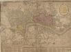
STRANGER'S GUIDE THROUGH the Streets of LONDON and WESTMINSTER
The title of this folding map appears along the top, with the sub-title in an oval at top right. A scale bar and compass star feature at the bottom right. An inset plan of Fleet Prison is included at top left. Squares, open spaces and built-up areas are all delineated in colour. Intended for visitors to the city, the map is divided into squares, with a quick-reference key in the panel below the main plan. Darton, William
LONDINI ANGLIAE REGNI METROPOLIS 70
The title of this map of London, Westminster and Southwark appears along the top. Figures of cherubs are depicted at top left facing the reference table at top right. The royal and city arms are illustrated at the foot of the plate, with a key to places in Southwark and compass rose at lower left, facing the portraits of King William III and Queen Mary at bottom right. The panorama of the city which features in the panel below the plan is based on Matthaeus Merian’s view published in "Theatrum Europeum" in 1720. Joannes de Ram had already published an identical map of the city. His name was removed from the plan when French mapmaker, engraver and publisher Jacques de la Feuille married de Ram’s widow and took over his publishing business. Feuille, Jacques de la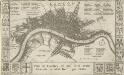
Plan de Londres tel quil Etoit avant l' incendre de 1666 Grave par Hollar
This is a later edition of a 1666map surveyed by Blome and engraved by Hollar. The title appears in French in a panel below the plan, with the key to streets and public buildings appearing in tables at top right, top left and bottom right. A compass star and scale bar are drawn at bottom right. Down both sides of the map are the coats of arms of the 12 Great City Companies (trade guilds), many of which have existed from the middle ages to the present day. Richard Blome was a heraldic writer and cartographer. His maps were often derivative, based on existing sources rather than original surveys. Blome, Richard
LONDINI ANGLIAE REGNI METROPOLIS 71
This map of London, Westminster and Southwark was issued in Peter Van der Aa's "La Galerie Agreable du Monde: Grande Bretagne et Irlande" (Vol. I, Plate 8). It is a later edition of a map first published in Amsterdam byJoannes de Ram at the end of the 17th Century. This edition features title along the top, a key to places in Southwark in cartouche at top left, a reference table at top right, and a bird's-eye view of Westwood Park in Worcestershire at the foot of the plate. The city arms, publisher's imprint, and a monument bearing the title in French appear towards the bottom of the sheet. Aa, Peter van der
London, Westminster, and Southwark
The map reports all the street names in London, Westminster and Southwark, with the scale bar given at bottom left. Faden, William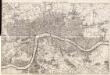
Maps of Old London-J. Rocque
Mitton, Geraldine Edith
A Mapp of the Cityies of LONDON & WESTMINSTER & BURROUGH of SOUTHWARK with their Suburbs and the Addition of the New Buildings
The title of this map of London, Westminster and Southwark appears along the top, with a reference table (flanked by sword and mace-bearer) at top left, a figure of Mercury (with the city arms on his shield) at top centre, and a second reference table below city arms at top right. The key to places in Southwark appear in a table at St. George's Fields, with compass star and scale bar at bottom centre and an allegorical figure of Father Thames at bottom right. John Oliver first issued this map in 1680.This is a later edition published and sold by John Bowles from his shop at the Black Horse in Cornhill. Oliver, John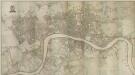
PLAN of the Cities of LONDON and WESTMINSTER the Borough of SOUTHWARK and PARTS adjoining Shewing every HOUSE. By R. Horwood
Map of London printed in 32 sheets and published sheet by sheet between 1792 and 1799, the work of several engravers working to the direction of the cartographer Richard Horwood. Horwood dedicated this map to the Trustees and Directors of the Phoenix Fire Office, reflecting that the protection of London from fire was at this time the reserve of numerous independent company brigades. This edition features a Phoenix at top left with the word "protection" emblazoned beneath it and is uncoloured in its entirety. The Tower of London is shown only by outline, as Horwood records that "The Internal Parts not distinguished being refused permission to take the Survey", testimony that a surveyor was not always welcome. Industries such as brewing and tanning, unwelcome in the city, are located south of the river in Southwark. Barclay Perkins & Co., the largest brewery in the world during the 1800s, is marked on the map, as is Guy's Hospital (for incurables). At the time of this map, the hospital had recently been extended to include a new ward for "lunatics". This map was re-issued, with additions and alterations, at least four times until 1819. Horwood, Richard
The London guide, or, a pocket plan of the cities of London & Westminster & borough of Southwak : with the new buildings &c. to the year 1767
Ellis, J. (John), fl. 1750-1800 Printed for Carington Bowles
A PLAN of the CITIES of LONDON & WESTMINSTER, THE BOROUGH OF SOUTHWARK and their Suburbs BY WILLIAM FADEN Geogr to the King MDCCLXXXV
The title of this map is arranged in an ornamental surround in which reclines the figure of Thamesis. Cross-hatching and stippling are used to distinguish land use, with differentiation made between fields and park land. Hyde Park features prominently on the plan. Deer were hunted here until 1768.It was also a well-known duelling ground. A particularly protracted and bloody duel was fought in 1772 between a Mr.Sheridan and a Captain Matthews over the honour of a certain Miss Lineley. Reports of the duel appeared in all the papers, scandalising the London public. Faden, William
LEIGH'S NEW PLAN OF LONDON 213
This map was published in the first edition of 'Leigh's New Picture of London’ in 1818. It shows Southwark Bridge and the proposed New North Road, across Finsbury Fields in Islington. Leigh, Samuel
LEIGH'S NEW PLAN OF LONDON 212
This is the second edition of a map of London first published in 'Leigh's New Picture of London'. The title appears along the top with a scale bar at the top right. The map is divided into half-mile squares with letters along the top borders for reference. It also shows Southwark Bridge and the proposed New North Road across Finsbury Fields. Hall, S.
PLAN of the Cities of LONDON and WESTMINSTER the Borough of SOUTHWARK and PARTS adjoining Shewing every HOUSE. By R. Horwood.
This magnificent map covers 32 sheets, each measuring 21" 5/8 x 19" 3/4. It was published sheet by sheet between 1792 and99 and was the work of several engravers under the direction of cartographer Richard Horwood. It is generally considered to be the most important London map of the 18th century. Horwood intended originally to show every house and its number but this was to prove impossible. Although every house is included the numbering was never completed. Horwood dedicated this map to the Trustees and Directors of the Phoenix Fire Office, reflecting that the protection of London from fire was at this time the reserve of numerous independent company brigades. The map is coloured, describing parks in green and the London Wall in red. The Tower of London is shown only by outline; Horwood records that: 'The Internal Parts not distinguished being refused permission to take the Survey’, evidence that a surveyor was not always welcome. Southwark was traditionally a district where the industries of brewing and tanning, unwelcome in the main city, were located. Barclay Perkins & Cos., which in the coming century was to become the largest brewery in the world, is marked on the map, as is Guy's Hospital ("for incurables") which at had recently been extended to include a new hospital for the psychiatrically disturbed. This map was reissued at least four times, with relevant additions and alterations, up until 1819. Horwood, Richard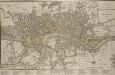
A NEW PLAN OF LONDON, WESTMINSTER AND SOUTHWARK 185
The title of this map appears at top right, with a compass rose and scale bar at bottom right. Below the plan is a list of public offices, with a special section dedicated to those at Somerset House. Designed by William Chambers, Somerset House was built in stages between 1771 and 1835, the first large block ever built to accommodate government offices. Over the years it has housed the Royal Navy, the Stamp Office, Hackney Coaches and Barge Master, the General Register of Births, Deaths and Marriages and the Inland Revenue. Laurie, Robert and Whittle, James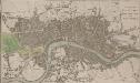
A PLAN OF LONDON WESTMINSTER AND SOUTHWARK
The title of this small map of London appears at top right, with publisher's imprint below the map. The river, city boundaries and open spaces are distinguished by colour use. Phillips, Richard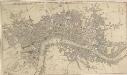
THE CITY GUIDE OR POCKET PLAN OF LONDON, WESTMINSTER And SOUTHWARK With the New Buildings to the Year 1765 125
The title of this pocket map runs along the top, with the publisher's imprint below the plan. Built-up areas in the City of London are represented by stippling, and by crosshatching outside the city. The map is a later edition Bowles' 1761 plan, with the addition of Queen Anne's Square and Portman Square in Marylebone and the new bridge and approaches at Blackfriars. Designed by Robert Mylne, this third bridge spanning the Thames was built between 1760 and 69. The nine semi-elliptical Portland-stone arches were replaced from 1860 to 69 by the present structure of five wrought-iron arches, each faced with cast iron, and a granite pier designed by Carr and Cubbitt. Bayly, J.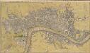
THE CITY GUIDE OR POCKET PLAN OF LONDON, WESTMINSTER And SOUTHWARK With the New Buildings to the Year 1765 121
The title of this map of London runs along the top, with built-up areas represented by stippling within the city boundaries, and hatched elsewhere. Fields and open spaces are shown in green. This first edition of the map does not show the new bridge at Blackfriars, added to the later editions. Bowles, John & Thomas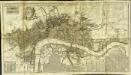
A new and exact plan of the cities of London and Westminster & the borough of Southwark to this present year
1 Plan auf 2 Blättern : Kupferdruck ; 53 x 101 cm Sayer; Bowen printed and published according to act of parliament by Robert Sayer opposite Fetter lane Fleet street
PLATTE GRONDT DER STADT LONDON MET AENWYSINGHE HOE DIE AFGEBRANDT
This map was published in Amsterdam after the great fire of 1666. The title appears along the top of the manuscript, with the key to parish churches (in scrolls) at top left and top right, and dividers at top right. An engraving of the great fire is inset at bottom right, entitled "BRANDENT LONDON". Below the plan, the fire is described in Dutch and French. Wit, Frederick de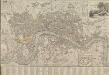
LONDON AND WESTMINSTER 1795
This is the second edition of a map published seven times until 1806. The title is embellished with an engraving of Father Thames, with St Paul's visible in the distance to one side of him. This edition includes an inset plan of the proposed Wet Docks. In 1796, the year this map was published, a Parliamentary Committee attempted to resolve the docking problems such as congestion, delays, lack of warehouse space and theft. The result was a number of project proposals for the building of new docks. However, none of these proposals were carried out, and the problem was not solved until private companies began building enclosed docks in 1802. Fairburn, John
Plan of the City of LONDON before the Fire Anno Domini 1666.
This is a retrospective plan of the City of London before the great fire of 1666. Place names are indicated by an alphanumeric key.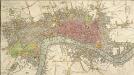
An IMPROVED PLAN of the CITIES of LONDON and WESTMINSTER and BOROUGH of SOUTHWARK, including the NEW BUILDINGS, ROADS &C.
This coloured map shows the built-up area of the City of London as a stippled pattern, with other built-up areas crosshatched. This map is a later edition of Kitching and Parker's 1765 plan, updated to include the new bridge and the approaches at Blackfriars as finally laid out. Designed by Robert Mylne, this third bridge spanning the Thames was built between 1760 and 69. The nine semi-elliptical Portland stone arches were replaced from 1860 to 69 by the present structure of five wrought-iron arches each faced with cast iron, and a granite pier designed by Cubitt and Carr. Kitching, Thomas and Parker, Henry
A NEW and Correct PLAN OF THE CITIES AND SUBURBS OF LONDON & WESTMINSTER & BOROUGH OF SOUTHWARK with the COUNTRY adjacent, the NEW BUILDINGS, ROADS &c. to the Year 1766
The title of this map runs along the top of the plan, which shows the new bridge at Blackfriars as "Pitt's Bridge". Designed by Robert Mylne, this third bridge spanning the Thames was built between 1760 and 69. The nine semi-elliptical Portland stone arches were replaced in a hundred years later by the present structure of five wrought-iron arches faced with cast-iron, and a granite pier designed by Cubitt and Carr. Gibson, John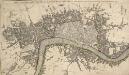
THE CITY GUIDE OR POCKET PLAN OF LONDON, WESTMINSTER And SOUTHWARK with the New Buildings to this Present Year 1764
This pocket map of London based on Rocque's map of 1748.Thetitle appears along the top, with the built-up area in the City of London described by stippling, and other built-up areas by crosshatching. The city boundaries are outlined in colour. The map shows the proposed new bridge at Blackfriars, but not the approaches. Designed by Robert Mylne, this third bridge to span the Thames was built between 1760 and 69. The nine semi-elliptical Portland-stone arches were replaced from 1860 to 69 by Cubitt and Carr’s present structure of five wrought-iron arches faced with cast iron and a granite pier.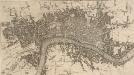
A NEW and Correct PLAN of LONDON WESTMINSTER and SOUTHWARK with the New Buildings to the Year 1770
This map was published in 'A new and complete history and survey of the cities of London and Westminster... revised by Henry Chamberlain.' Only one edition was published and some copies omit the name of the engraver, J. Flyn. The Chelsea Waterworks are shown in Hyde Park. This was the first water-plant to use slow sand filtration to purify the water it supplied. Flyn, J.