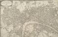
Maps of Kensington and Chelsea

Knightsbridge near Hyde Park Corner
The surface of this stretch of Knightsbridge is dirt road rather than paved. The elevation at the top of the sheet shows trees in Hyde Park behind the brick wall. The wall was erected by Charles II after he took the park back into royal hands after the Restoration in 1660.Hyde Park was the largest of all the Royal parks, extending over 340 acres of land. It was originally a hunting ground for deer, boars and wild bull. Bequeathed to the monks of Westminster after the conquest of Geoffrey de Mandeville in the 1140s, the park was appropriated by Henry VIII at the dissolution of the monasteries in 1536. The park was opened to the public at the beginning of the 17th century and deer were hunted there until 1768. Salway, Joseph
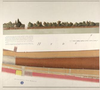
Knightsbridge showing the Horse Barracks Sheet 3-A
The Horse Guard Barracks are depicted on the north side of Knightsbridge. Built at the end of the 18th century, shortly after the French Revolution, when the authorities feared insurrections at home, the barracks provided accommodation for 600 men and 500 horses. By the 1870s the barracks, considered too cramped and dilapidated, were pulled down and replaced by new buildings designed by Wyatt in 1880. In 1959 these were further replaced by Basil Spence's 270 feet high tower block. A milestone outside the barracks indicates half mile distance to Hyde Park Corner. Salway, Joseph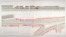
Plan of the road executed for the Kensington Turnpike Trustees by Joseph Salway in 1811, extending from Hyde Park Corner to Counter's Bridge
London Topographical Society
Insurance Plan of London Western District Vol. A: sheet 12
1 : 480 This detailed 1901 plan of London is one of a series of forty-one sheets in an atlas originally produced to aid insurance companies in assessing fire risks. The building footprints, their use (commercial, residential, educational, etc.), the number of floors and the height of the building, as well as construction materials (and thus risk of burning) and special fire hazards (chemicals, kilns, ovens) were documented in order to estimate premiums. Names of individual businesses, property lines, and addresses were also often recorded. Together these maps provide a rich historical shapshot of the commercial activity and urban landscape of towns and cities at the time. The British Library holds a comprehensive collection of fire insurance plans produced by the London-based firm Charles E. Goad Ltd. dating back to 1885. These plans were made for most important towns and cities of the British Isles at the scales of 1:480 (1 inch to 40 feet), as well as many foreign towns at 1:600 (1 inch to 50 feet). Chas E Goad Limited Chas E Goad Limited
Insurance Plan of London West Vol. A: sheet 12
1 : 480 This detailed 1891 plan of London is one of a series of fourteen sheets in an atlas originally produced to aid insurance companies in assessing fire risks. The building footprints, their use (commercial, residential, educational, etc.), the number of floors and the height of the building, as well as construction materials (and thus risk of burning) and special fire hazards (chemicals, kilns, ovens) were documented in order to estimate premiums. Names of individual businesses, property lines, and addresses were also often recorded. Together these maps provide a rich historical shapshot of the commercial activity and urban landscape of towns and cities at the time. The British Library holds a comprehensive collection of fire insurance plans produced by the London-based firm Charles E. Goad Ltd. dating back to 1885. These plans were made for most important towns and cities of the British Isles at the scales of 1:480 (1 inch to 40 feet), as well as many foreign towns at 1:600 (1 inch to 50 feet). Chas E Goad Limited Chas E Goad Limited
Knightsbridge showing the Fulham Road and Sloane Street
During the 18th century, a system of paid watchmen and constables was introduced to police the area replacing the ancient system of parish watch. A watch house is indicated at the junction of Knightsbridge and the Fulham Road, today's Brompton Road. This was the ancient track to the village of Brompton. Sloane Street, connecting Knightsbridge to Sloane Square, is indicated as a dirt track. Planned by Henry Holland, the road was built in 1780. On the north side of the road, terraced houses and private gardens are shown in plan form and elevation revealing the formal designs of lawns and cobblestone paths. Salway, Joseph
Knightsbridge showing the Halfway House
The Halfway House is depicted in plan and elevation on the north side of the road on the site of today's Prince of Wales Gate. This ancient inn, with its ramshackle stables and pigsties, had long been popular with highwaymen in the area. Salway, Joseph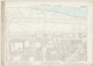
London VI.90 - OS London Town Plan
1 : 1056 Topographic maps Ordnance Survey Ordnance Survey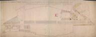
Survey of the District of Hans Town
Drawn survey of the district of Hans Town in Chelsea, with the boundary of the district outlined in red. Indian ink is used to indicate buildings in the Codagan Estate, the rest of the buildings being held by Henry Holland on lease from Codagan.
Plan of Belgrave Square
1 : 1596 This drawn plan also shows adjoining properties in Knightsbridge. Earl Grosvenor was granted permission by Parliament to develop the ten acre site in 1826, and commisioned the young architect George Basevi, a pupil of Sir John Soane, to design the square. Chawner, Thomas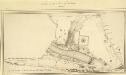
MILITARY SKETCH OF HYDE PARK
This plan shows the barracks along Knightsbridge erected for the Horse Guard at the end of the 18th century. The title appears at lower left, below the scale bar. At over 340 acres the largest of the royal parks, Hyde Park was originally a hunting ground for deer, boars and wild bull. Bequeathed to the monks of Westminster after the conquest of Geoffrey de Mandeville in the 1140s, the park was appropriated by Henry VIII at the dissolution of the monasteries in 1536. The park was opened to e public at the beginning of the 17th century and remained a deer-hunting ground until 1768. Baker, B.
London (1915- Numbered sheets) IV.16 (includes: City Of Westminster; Kensington; Paddington) - 25 Inch Map
1 : 2500 Topographic maps Ordnance Survey Ordnance Survey
London (First Editions c1850s) XLII (includes: City Of Westminster; Kensington; Paddington) - 25 Inch Map
1 : 2500 Topographic maps Ordnance Survey Ordnance Survey
PLAN OF HYDE PARK as it was in 1725
1 : 792 This retrospective plan of Hyde Park was produced from an earlier plan held in the Vestry Room in St George's Church, Hanover Square. Its title features at top right, with the scale bar at top left. At over 340 acres of land the largest of all the royal parks, Hyde Park was originally a hunting ground for deer, boars and wild bull. Bequeathed to the monks of Westminster after the conquest of Geoffrey de Mandeville in the 1140s, the park was appropriated by Henry VIII at the dissolution of the monasteries in 1536. The park was opened to the public at the beginning of the 17th century, and remained a deer hunting ground until 1768. Neele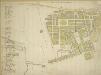
Plan of the Parish of St. George, Hanover Square
The streets of the parish are numbered in red ink for reference, with a key along the left side of the sheet.The Parish of St George was created in 1725 and covered an area previously in the Parish of St. Martin-in-the-Fields that stretched from Regent Street (then called Swallow Street) to the Serpentine, and from Oxford Street to Mayfair, Belgravia and Pimlico.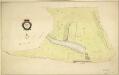
HYDE PARK
1 : 3960 The title and compass star of this plan appear at middle left, with them scale bar at bottom right. At over 340 acres the largest of all the royal parks, Hyde Park was originally a hunting ground for deer, boars and wild bull. Bequeathed to the monks of Westminster after the conquest of Geoffrey de Mandeville in the 1140s, the park was appropriated by Henry VIII at the dissolution of the monasteries in 1536. The park was opened to the public at the beginning of the 17th century, and remained a deer hunting ground until 1768. Bennett, S.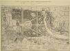
A Plan of the Palace Gardens and TOWN of KENSINGTON
1 : 4800 The title of this plan of Kensington Palace and gardens appears in English and French, with scale bars and a key to architectural and natural features, in a panel below the plan. Kensington Gardens were originally attached to Nottingham House, which was bought in 1689 by William III and turned into Kensington Palace. Queen Mary took a great interest in the gardens and had them landscaped by royal gardeners in formal Dutch patterns. Uprooted by order of Queen Anne at the beginning of the 18th century, the Dutch gardens were replaced in 1726 by this Wise and Bridgeman design, including the round pond, the Broad Walk and the Temple Lodge. Rocque, John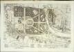
A plan of the palace gardens and town of Kensington
1 Plan : Kupferdruck ; 28 x 48 cm Rocque; Deharme John Rocque
Drawn plan of the Goring Estate] 3
This is a copy by Crace of a plam of the Goring Estate as it was in 1640. The drawing shows the site in Mulberry Garden Fields where Buckingham Palace was built. Crace, Frederick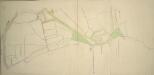
Drawn plan of the Manor of Eybury
1 : 3192 This is a 19th-Century copy of a 1614 survey found in the records relating to the Grosvenor Estate. The plan shows the low-lying canals running from Oxford Street to the River Thames that were later used to operate the Chelsea Waterworks. Saunders, G.
Map SHEWING THE IMPROVEMENTS Now in Progress at the WEST END OF LONDON
1 : 3840 The title of this plan of Hanover Square and the Parish of St George appears with the publisher's imprint at lower right. Compass star and scale bars are featured at top left. The plan shows Buckingham Palace and additions made in the Regency period to the street plan. The Parish of St. George was established in 1725 and extended from Regent Street (then called Swallow Street) to the Serpentine, and from Oxford Street to include the whole of Mayfair, Belgravia and Pimlico. Ward, E. T.
London VI.SE - OS Six-Inch Map
1 : 10560 Topographic maps Ordnance Survey Ordnance Survey
MAP of the GROSVENOR ESTATE (tinted pink) as it was in the Year 1723. with the intended Streets about Grosvenor Square.
1 : 5592 The title of this plan features at top right, with compass star at middle right and explanatory note at bottom right. The boundaries of the St George parish are outlined in red, with the properties in the estate in pink, and parks and open spaces in green. The plan shows the proposed new street plans for Grosvenor Square, but not the Chelsea waterworks,which featured in the original drawing from which this print was produced.
Plan of the Parish of PADDINGTON in the County of Middlesex 4
1 : 9600 The title, imprint and compass rose of this plan appear at top right with scale bars at the foot of the plate. It is accompanied by handwritten note with key to land acquired by the Grand Junction Canal Company from the Bishop of London(depicted in red) with the proposed new roads into the Bishop's estate.These roads are represented by a brown double-dotted line and were added by the surveyor Ralph Samuel Cockrell. With Cockrell's additions, this plan was presented to the Commissioners of Sewers for consultation on the best way to lay out a sewage and draining system in the area. Gutch, George
A New PLAN of the CITY and LIBERTY of WESTMINSTER, Exhibiting all the New Streets & Roads, with the Residences of the Principal Nobility, Public Offices, &c. Not extant in any other Plan.
This map is by Thomas Jeffreys, an exceptional cartographer and publisher whose productions, including maps of North America, are considered to be among the finest of his age. This map shows the new developments in Westminster by use of a colour coding system indicating varying stages of completion. Portman Square (W1), a contemporary development, was begun the year before this map was published. It was built between 1764 and 84 for the landlord Henry William Portman on what was then considered the outskirts of town. Thomas Jeffreys
Plan of the parish of PADDINGTON in the County of Middlesex 6
The development of Paddington began at the end of the Napoleonic wars, when the Bishop of London granted permission for building on his estate north of Hyde Park. Under Gutch's supervision, works continued into the 1850s, extending to Bayswater and the Edgware and Harrow Roads. The title of this plan appears at top left, with compass rose at top right and scale bar at bottom left. Also at bottom left is a key to the land acquired by the Grand Junction Canal Company from the Bishop of London. This the area in red on the plan, which also shows the final proposals for the new street plan at Bayswater. Gutch, George
Plan of the parish of PADDINGTON in the County of Middlesex 7
The development of Paddington began at the end of the Napoleonic wars, when the Bishop of London granted permission for building on his estate north of Hyde Park. Under Gutch's supervision, works continued into the 1850s, extending to Bayswater and the Edgware and Harrow Roads. The title of this plan appears at top left, with compass rose at top right and scale bar at bottom left. It shows the final street plan, with the Bishop of London's estate outlined in green, the Great Western Railway terminus in red, and the Paddington estate in yellow. Gutch, George
A PLAN of HYDE-PARK with the CITY and LIBERTIES of WESTMINSTER &c. Shewing the several IMPROVEMENTS propos'd
This plan shows renovations in Hyde Park and around Westminster.Two Royal palaces have been planned, in Hyde Park and Green Park. The red lines show an intention to regularize the street plan, replacing the narrow irregular streets with a gridlike formation. Gwynn, John
Charles Booth's descriptive map of London poverty 1889
Charles Booth