Maps of Kensington and Chelsea
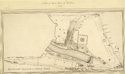
MILITARY SKETCH OF HYDE PARK
This plan shows the barracks along Knightsbridge erected for the Horse Guard at the end of the 18th century. The title appears at lower left, below the scale bar. At over 340 acres the largest of the royal parks, Hyde Park was originally a hunting ground for deer, boars and wild bull. Bequeathed to the monks of Westminster after the conquest of Geoffrey de Mandeville in the 1140s, the park was appropriated by Henry VIII at the dissolution of the monasteries in 1536. The park was opened to e public at the beginning of the 17th century and remained a deer-hunting ground until 1768. Baker, B.
HYDE PARK
1 : 3960 The title and compass star of this plan appear at middle left, with them scale bar at bottom right. At over 340 acres the largest of all the royal parks, Hyde Park was originally a hunting ground for deer, boars and wild bull. Bequeathed to the monks of Westminster after the conquest of Geoffrey de Mandeville in the 1140s, the park was appropriated by Henry VIII at the dissolution of the monasteries in 1536. The park was opened to the public at the beginning of the 17th century, and remained a deer hunting ground until 1768. Bennett, S.
PLAN OF HYDE PARK as it was in 1725
1 : 792 This retrospective plan of Hyde Park was produced from an earlier plan held in the Vestry Room in St George's Church, Hanover Square. Its title features at top right, with the scale bar at top left. At over 340 acres of land the largest of all the royal parks, Hyde Park was originally a hunting ground for deer, boars and wild bull. Bequeathed to the monks of Westminster after the conquest of Geoffrey de Mandeville in the 1140s, the park was appropriated by Henry VIII at the dissolution of the monasteries in 1536. The park was opened to the public at the beginning of the 17th century, and remained a deer hunting ground until 1768. Neele
Plan Generale du Palais & Jardins de Kensington Situe dans la Conte de Middlesex a 2 miles de Londres tres Exactement Leve dessiene & Grave par Jean Rocque 1736
1 : 2400 On this plan of Kensington Palace and gardens, the key is at bottom left, with title and dedication at bottom centre, and scale bar at bottom left. The Kensington Gardens were originally attached to Nottingham House, which was bought in 1689 by William III and turned into Kensington Palace. Queen Mary took a great interest in the gardens and had them landscaped by royal gardeners in formal Dutch patterns. Uprooted by order of Queen Anne at the beginning of the 18th century, the Dutch gardens were replaced in 1726 by this Wise and Bridgeman design, which included the round pond, the Broad Walk and the Temple Lodge. Rocque, John
London VI.80 - OS London Town Plan
1 : 1056 Topographic maps Ordnance Survey Ordnance Survey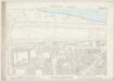
London VI.90 - OS London Town Plan
1 : 1056 Topographic maps Ordnance Survey Ordnance Survey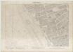
London VII.71 - OS London Town Plan
1 : 1056 Topographic maps Ordnance Survey Ordnance Survey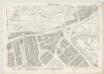
London VII.81 - OS London Town Plan
1 : 1056 Topographic maps Ordnance Survey Ordnance Survey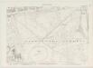
London VI.79 - OS London Town Plan
1 : 1056 Topographic maps Ordnance Survey Ordnance Survey
London VI.89 - OS London Town Plan
1 : 1056 Topographic maps Ordnance Survey Ordnance Survey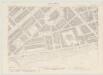
London VI.70 - OS London Town Plan
1 : 1056 Topographic maps Ordnance Survey Ordnance Survey
Knightsbridge showing the Halfway House
The Halfway House is depicted in plan and elevation on the north side of the road on the site of today's Prince of Wales Gate. This ancient inn, with its ramshackle stables and pigsties, had long been popular with highwaymen in the area. Salway, Joseph
Insurance Plan of London Western District Vol. A: sheet 12
1 : 480 This detailed 1901 plan of London is one of a series of forty-one sheets in an atlas originally produced to aid insurance companies in assessing fire risks. The building footprints, their use (commercial, residential, educational, etc.), the number of floors and the height of the building, as well as construction materials (and thus risk of burning) and special fire hazards (chemicals, kilns, ovens) were documented in order to estimate premiums. Names of individual businesses, property lines, and addresses were also often recorded. Together these maps provide a rich historical shapshot of the commercial activity and urban landscape of towns and cities at the time. The British Library holds a comprehensive collection of fire insurance plans produced by the London-based firm Charles E. Goad Ltd. dating back to 1885. These plans were made for most important towns and cities of the British Isles at the scales of 1:480 (1 inch to 40 feet), as well as many foreign towns at 1:600 (1 inch to 50 feet). Chas E Goad Limited Chas E Goad Limited
Insurance Plan of London West Vol. A: sheet 12
1 : 480 This detailed 1891 plan of London is one of a series of fourteen sheets in an atlas originally produced to aid insurance companies in assessing fire risks. The building footprints, their use (commercial, residential, educational, etc.), the number of floors and the height of the building, as well as construction materials (and thus risk of burning) and special fire hazards (chemicals, kilns, ovens) were documented in order to estimate premiums. Names of individual businesses, property lines, and addresses were also often recorded. Together these maps provide a rich historical shapshot of the commercial activity and urban landscape of towns and cities at the time. The British Library holds a comprehensive collection of fire insurance plans produced by the London-based firm Charles E. Goad Ltd. dating back to 1885. These plans were made for most important towns and cities of the British Isles at the scales of 1:480 (1 inch to 40 feet), as well as many foreign towns at 1:600 (1 inch to 50 feet). Chas E Goad Limited Chas E Goad Limited
Kensington Gore Sheet 7
Among the residents of Kensington Gore was the philanthropist and parliamentarian William Wilberforce, whose name is associated with the campaign for the abolition of the slave trade. Gore House, wherehe lived between 1808 and 1821, is depicted in plan form on the south side of Kensington Gore. Built in the 1750s, the house was decorated by the architect Robert Adams. It was the most easterly of a row of mansions built in the 18th century between Palace Gate and Knightsbridge. Salway, Joseph
Knightsbridge, 1 Mile from Hyde Park Corner
Gray's Nursery and Seed Shopis depicted in plan form on the south side of this stretch of Knightsbridge, next to property belonging to James Vere. A milestone on the north side of the road indicates a distance ofone mile to Hyde Park Corner, where the toll road terminated. Salway, Joseph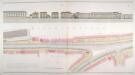
Plan of the road executed for the Kensington Turnpike Trustees by Joseph Salway in 1811, extending from Hyde Park Corner to Counter's Bridge
London Topographical Society
Knightsbridge showing the Horse Barracks Sheet 3-A
The Horse Guard Barracks are depicted on the north side of Knightsbridge. Built at the end of the 18th century, shortly after the French Revolution, when the authorities feared insurrections at home, the barracks provided accommodation for 600 men and 500 horses. By the 1870s the barracks, considered too cramped and dilapidated, were pulled down and replaced by new buildings designed by Wyatt in 1880. In 1959 these were further replaced by Basil Spence's 270 feet high tower block. A milestone outside the barracks indicates half mile distance to Hyde Park Corner. Salway, Joseph
Kensington Gore Sheet 7-A
Kensington Gore, depicted here opposite Hyde Park, takes its name from "gara", an old English word describing a triangular plot of land which was left when ploughing fields of irregular shape. The property at No.1 Kensington Gore marks the boundary between the parishes of Kensington and St Margaret Westminster. A well, shown along the north side of the road, and a horse trough outside the Hand and Flower public house, testify to the incredible level of detail with which Salway recorded all features of the road managed by the Turnpike Trust. Salway, Joseph
Insurance Plan of London West Vol. A: sheet 13-1
1 : 480 This detailed 1891 plan of London is one of a series of fourteen sheets in an atlas originally produced to aid insurance companies in assessing fire risks. The building footprints, their use (commercial, residential, educational, etc.), the number of floors and the height of the building, as well as construction materials (and thus risk of burning) and special fire hazards (chemicals, kilns, ovens) were documented in order to estimate premiums. Names of individual businesses, property lines, and addresses were also often recorded. Together these maps provide a rich historical shapshot of the commercial activity and urban landscape of towns and cities at the time. The British Library holds a comprehensive collection of fire insurance plans produced by the London-based firm Charles E. Goad Ltd. dating back to 1885. These plans were made for most important towns and cities of the British Isles at the scales of 1:480 (1 inch to 40 feet), as well as many foreign towns at 1:600 (1 inch to 50 feet). Chas E Goad Limited Chas E Goad Limited
Insurance Plan of London Western District Vol. A: sheet 13-1
1 : 480 This detailed 1901 plan of London is one of a series of forty-one sheets in an atlas originally produced to aid insurance companies in assessing fire risks. The building footprints, their use (commercial, residential, educational, etc.), the number of floors and the height of the building, as well as construction materials (and thus risk of burning) and special fire hazards (chemicals, kilns, ovens) were documented in order to estimate premiums. Names of individual businesses, property lines, and addresses were also often recorded. Together these maps provide a rich historical shapshot of the commercial activity and urban landscape of towns and cities at the time. The British Library holds a comprehensive collection of fire insurance plans produced by the London-based firm Charles E. Goad Ltd. dating back to 1885. These plans were made for most important towns and cities of the British Isles at the scales of 1:480 (1 inch to 40 feet), as well as many foreign towns at 1:600 (1 inch to 50 feet). Chas E Goad Limited Chas E Goad Limited
Knightsbridge showing the Fulham Road and Sloane Street
During the 18th century, a system of paid watchmen and constables was introduced to police the area replacing the ancient system of parish watch. A watch house is indicated at the junction of Knightsbridge and the Fulham Road, today's Brompton Road. This was the ancient track to the village of Brompton. Sloane Street, connecting Knightsbridge to Sloane Square, is indicated as a dirt track. Planned by Henry Holland, the road was built in 1780. On the north side of the road, terraced houses and private gardens are shown in plan form and elevation revealing the formal designs of lawns and cobblestone paths. Salway, Joseph
Drawn Plan of of the Site of Camelford House
1 : 312 Drawn plan of the ground plot of the house built by Thomas Pitt, later Lord Camelford, at the corner of Oxford Street and Park Lane. Saunders, George
Knightsbridge showing the Horse Barracks
The Horse Guard Barracks, depicted on the north side of Knightsbridge, were built shortly after the French Revolution at the end of the 18th century when the authorities feared insurrections at home. By the 1870s the barracks, considered too cramped and dilapidated, were pulled down and replaced by new buildings designed by Wyatt in 1880. The estate shown on Trevor Terrace, on the south side of the road, takes its name from Sir John Trevor, the Master of the Rolls and Speaker of the House of Commons, who built a house on this site in circa 1700. The estate illustrated here was built by his cousin, Arthur Trevor Hill, in the early 19th century. Salway, Joseph
Knightsbridge showing Hyde Park Sheet 5
The surface of thisstretch of Knightsbridge is dirt roadrather than paved. The elevation at the top of the sheet shows trees in Hyde Park behind the brick wall. The wall was erected byCharles II afterhe took the park back into royal handsafter theRestoration in 1660. The largest of all the Royal parks, extending over 340 acres of land, Hyde Park was originally a hunting ground for deer, boars and wild bull. Bequeathed to the monks of Westminster after the conquest of Geoffrey de Mandeville in the 1140s, the park was appropriated by Henry VIII at the dissolution of the monasteries in 1536. The park was opened to the public at the beginning of the 17th century and deer were hunted there until 1768. Salway, Joseph
Knightsbridge showing the Horse Barracks Sheet 4-A
The Horse Guard Barracks, depicted hereon the north side of Knightsbridge, were built shortly after the French Revolution, at the end of the 18th century, when the authorities feared insurrections at home. The barracks housed 600 men in the Household Cavalry and 500 horses. By the 1870s the barracks, considered too cramped and dilapidated, were pulled down and replaced by new buildings designed by Wyatt in 1880. In1959 these were further replaced by Basil Spence's 270 feet high tower block. Salway, Joseph
Knightsbridge showing Cannon Brewhouse
Knightsbridge isrepresented here in plan and elevation. The architectural details of thebuildings are faithfullyillustrated anda taste for order and symmetry is revealed by the garden plans,showing neat lawns andcobbled paths. Lamp posts are numbered, water pumps and drains are recorded by miniature representations.The Westbourne Brook features in the drawing. Fed by five streamswhich joined near Kilburn, it rose in West Hampstead and flowed under Knightsbridge and south to the Thames.The bridge that can be seen in the distance crossing the Westbourne was where, according to legend,two knights fought to their deaths. It is due to this legend that the village came to be called Knightsbridge. It was plagued by highway men and much celebrated for its taverns. The White Hart, shown here, is known to have existed as early as 1631. Salway, Joseph
Hyde Park Corner showing the Piccadilly Turnpike
This section of drawing shows the Piccadilly Turnpike at Hype Park Corner, the terminus of one of the ancient highways leading into London. A weighing engine is shown in red ink, indicating that tolls were increased depending on the weight of the vehicle and load. The meticulous nature of these drawings is revealed by the numbered lamp posts, each drawn with a shadow. Private gardens are shown in plan form, revealing the formal designs of lawns and cobblestone paths. St George's Hospital, located opposite the park, was founded in 1733 by a group of Governors from Westminster Hospital who chose Lanesborough House as the building to house their new hospital. Knightsbridge had a reputation for healthiness and they wanted their patients to benefit from the country air. Salway, Joseph
Knighsbridge showing Hyde Park
Hyde Park is shown hereon the north side of the turnpike road. The largest of all the Royal parks, extending over 340 acres of land, Hyde Park was originally a hunting ground for deer, boars and wild bull. Bequeathed to the monks of Westminster after the conquest of Geoffrey de Mandeville in the 1140s, the park was appropriated by Henry VIII at the dissolution of the monasteries in 1536. The park was opened to the public at the beginning of the 17th century and deer were hunted there until 1768. Salway, Joseph