Maps of Hampshire
SOUTHAMPTONIAE Comitatus
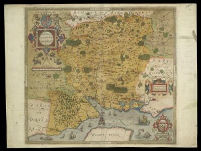
This is a map of Hampshire by Christopher Saxton, datingfrom 1575. It forms part of an atlas that belonged to William Cecil Lord Burghley, Elizabeth I’s Secretary of State. Burghley used this atlas to illustrate domestic matters. This map is actually a proof copy of one which forms part of Christopher Saxton’s Atlas of England and Wales. This atlas was first published as a whole in 1579. It consists of 35 coloured maps depicting the counties of England and Wales. The atlas is of great significance to British cartography as it set a standard of cartographic representation in Britain and the maps remained the basis for English county mapping, with few exceptions, until after 1750. During the reign of Elizabeth I, map use became more common, with many government matters referring to increasingly accurate maps with consistent scales and symbols, made possible by advances in surveying techniques. Illustrating the increasing use of maps in government matters, Lord Burghley, who had been determined to have England and Wales mapped in detail from the 1550s, selected the cartographer Christopher Saxton to produce a detailed and consistent survey of the country. The financier of the project was Thomas Seckford, Master of Requests at the Court of Elizabeth I, whose arms appear, along with the royal crest, on each map. Lord Burghley added several place names to the map. This map was engraved by Leonardus Terwoort, one of a team of seven English and Flemish engravers employed to produced the copper plates for the atlas. Saxton, Christopher Terwoort, Leonardus Antverpianus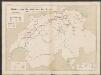
Hantonia Sive Southantonensis Comitatus Vulgo Hant-Shire. [Karte], in: Le théâtre du monde, ou, Nouvel atlas contenant les chartes et descriptions de tous les païs de la terre, Bd. 4, S. 154.
1 Karte aus Atlas Blaeu, Willem Janszoon und Blaeu, Joan Blaeu, Willem Janszoon
Hantonia sive Southantonensis Comitatus Vulgo Hant-Shire. [Karte], in: Theatrum orbis terrarum, sive, Atlas novus, Bd. 4, S. 174.
1 Karte aus Atlas Blaeu, Joan Blaeu, Willem Janszoon
Hantonia sive Southantonensis Comitatus Vulgo Hant-Shire. [Karte], in: Theatrum orbis terrarum, sive, Atlas novus, Bd. 4, S. 174.
1 Karte aus Atlas Blaeu, Joan Blaeu, Willem Janszoon
Hantonia, sive Southantonensis Comitatus, vulgo Hantshire.

HANTONIA | SIVE | SOVTHANTONENSIS | COMITATVS | Vulgo | HANT-SHIRE.
[Amsterdam : Joan Blaeu]
Bacon's twentieth century map of Hampshire
1 : 125000 titelvariant: Bacon's new map of Hampshire; Annotatie: Omslagtitel: Bacon's new map of Hampshire; Met plaatsnamenregister en afstandentabel London : Bacon
Southern England
1 : 21120 Triangulation allows the relative location of individual topographical features to be plotted accurately. This drawing shows the primary triangulation of southern England, the lengths of the sides of each triangle being noted. Stations shown include Dunnose, Bagshot Heath, Inkpen Hill and the Salisbury Plain base. The points of the triangles provided the surveyor with references to which, by measurement or angular observation, he could precisely relate the position of other topographical features. Angular observations were made using a theodolite. Triangulation points were carefully chosen. Elevated sites were preferred where possible, particularly the tops of hills and church towers.
Hantoniae comitatus cum Berchia
1 : 240000 Amstelodami : apud Joannem Janssonium
SOUTHAMPTONIA
This map of Hampshire is from the 1583 edition of the Saxton atlas of England and Wales.This atlas was first published as a whole in 1579. It consists of 35 coloured maps depicting the counties of England and Wales. The atlas is of great significance to British cartography as it set a standard of cartographic representation in Britain and the maps remained the basis for English county mapping, with few exceptions, until after 1750. During the reign of Elizabeth I map use became more common, with many government matters referring to increasingly accurate maps with consistent scales and symbols, made possible by advances in surveying techniques. Illustrating the increasing used of maps in government matters, Lord Burghley, Elizabeth I’s Secretary of State, who had been determined to have England and Wales mapped in detail from the 1550s, selected the cartographer Christopher Saxton to produce a detailed and consistent survey of the country. The financier of the project was Thomas Seckford Master of Requests at the Court of Elizabeth I, whose arms appear, along with the royal crest, on each map. Saxton, Christopher Ryther, Augustine
Hantoniae Comitatus cum Bercheria. [Karte], in: Novus atlas absolutissimus, Bd. 7, S. 153.
1 Karte aus Atlas Janssonius Offizin
A new improved map of Hampshire
1 Karte : Kupferdruck ; 51 x 67 cm Kitchin; Hinton sold by I. Hinton at the Kings Arms in St. Pauls Church Yard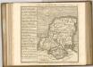

Hantonia sive Sovthantonensis comitatvs vulgo Hant-shire
1 Karte : Kupferdruck ; 40 x 48 cm Blaeu Joan Blaeu
Hantoniæ comitatus cum Bercheria
1 Karte : Kupferdruck ; 42 x 53 cm Valck; Schenk apud G. Valk et P. Schenk
New Forrest & Isle of Wight, Sheet 33 - Bartholomew's "Half Inch to the Mile Maps" of England & Wales
1 : 126720 Topographic maps Bartholomew, John George John Bartholomew & Co
Sheets 15-16. (Cary's England, Wales, and Scotland).
1 : 360000 Cary, John, ca. 1754-1835
To the right honorable the master, wardens & elder brethren of the Trinity House, this chart of Spithead is ... dedicated
1 : 110000 Heather, W. (William) Heather and Williams
Carte réduite de l'isle de Wight et costes voisines
1 Karte : Kupferdruck ; 53 x 82 cm Bellin s.n.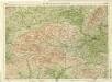
Berkshire, Sheet 29 - Bartholomew's "Half Inch to the Mile Maps" of England & Wales
1 : 126720 Topographic maps Bartholomew, John George John Bartholomew & Co
Winchester - OS One-Inch Map
1 : 63360 Topographic maps Ordnance Survey Ordnance Survey
Chichester - OS One-Inch Map
1 : 63360 Topographic maps Ordnance Survey Ordnance Survey
Aldershot - OS One-Inch Map
1 : 63360 Topographic maps Ordnance Survey Ordnance Survey
Map of Hampshire, including the Isle of Wight, 4
1 Blatt : 53 x 69 cm s.n.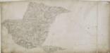
Alresford 19
1 : 31680 Relief is indicated on this plan by shading and interlining ('hachuring'). The concern with depicting relief accurately reflects the military emphasis of these drawings: knowledge of the lie of the land could greatly help the efficient movement of regiments. The right-hand side of the drawing is unfinished, featuring main roads only.
Map of Hampshire, including the Isle of Wight, 3
1 Blatt : 53 x 68 cm s.n.
Nieuwe afteekening van de reede van Portsmouth, Spithead en St. Hellens Road aen de Oost zijde vant eijland Wight in het Kanaal
England Johannes van Keulen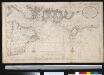
Nieuwe afteekening van de reede van Portsmouth, Spithead en St. Hellens Road aen de Oost zijde vant eijland Wight in het Kanaal
England Gerard van Keulen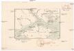
O anglickém průlivu
1 : 290000 Isle of Wight (Anglie) Hanf, Norbert Kořenský, Josef J. Otta