Maps of Greenland

Carte marine, de la B. de Baffin, et une partie d'Hudson, d'Island et Groenland
1 Karte : Kupferdruck ; 42 x 48 cm Königliche Akademie der Wissenschaften
185-186. North Canada, Greenland. The World Atlas.
1 : 7500000 USSR (Union of Soviet Socialist Republics).
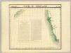
A General Chart ... Davis Straits & Baffin Islands Bay.
1 : 19000000 Melish, John
Gletscherkarte.
Berghaus, Hermann
Groenland und die angraenzenden Laender nach den Charten und Berichten von Cranz, Egede, Gieseke, Graah, Olavsen, Parry, Ross, Scoresby, Thorhallesen u.a.
1 : 5000000 entworfen und gezeichnet von Theodor Gliemann Weimar : Verlag des Geograph. Instituts
Gletscherkarte
Atlas der Geologie Zittel, K.v. ; Berghaus, Hermann Justus Perthes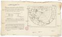
Vorstellung des Meers in Norden von Asien und America, nebst der Berechnung von dessen Grösse und Ausdehnung
Asie severní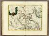
La Baja D'Hudson Terra di Labrador e Groenlandia.
1 : 9750000 Zatta, Antonio
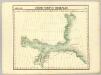
Septemtrionaliora Americæ à Groenlandia, per freta Davidis et Hudson, ad Terram Novam
1 Karte : Kupferdruck ; 48 x 55 cm Renard Louis Renard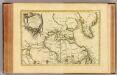
L'Amerique Septentrionale 1.
1 : 10050000 Bonne, Rigobert, 1727-1794
Old Greenland.
1 : 9850000 Bowen, Emanuel
Greenland, Labrador.
1 : 15000000 Peterson, Augusts
[142][145] Septemtrionaliora Americae à Groenlandia, ..., uit: Atlas sive Descriptio terrarum orbis
Annotatie: Gedigitaliseerde versie. Amsterdam. Heiloo : Picturae (vervaardiger), 2015. tiff-bestand. Gedigitaliseerd: 07-01-2015; Origineel: Universiteitsbibliotheek Vrije Universiteit (XL.05127.-) ; Netherlands; Titelpagina ontbreekt Wit, Frederik de Amsterdam : Frederick de Wit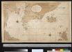
Nieuwe afteekening van de Straat Davits van Hitland tot aen de Straet Davids
Atlantic Ocean Gerard van Keulen
Feuille 1 (A I), uit: Carte géologique internationale de l'Europe : la carte, votée au congrès géologique international de Bologne en 1881, est exécutée conformément aux décisions d'une commission internationale, avec le concours des gouvernements, sous le dir. de M.M. Beyrich et Hauchecorne
Annotatie: Blad 48 gamme des couleurs; blad 49: bladwijzer en titelblad Heinrich Ernst Beyrich 1815-1896; Wi. Hauchecorne Berlin : Reimer / (Berlin: Institut lithographique)
Baffin Bay journey.
1 : 3200000 Hayes, Isaac Israel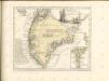
Decouvertes Boreales. Amer. Sep. 2.
1 : 1641836 Vandermaelen, Philippe, 1795-1869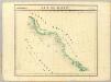
Baie de Baffin. Amer. Sep. 3.
1 : 1641836 Vandermaelen, Philippe, 1795-1869
North America polar regions : Baffin Bay to Lincoln Sea showing the most recent discoveries including those of U.S.S. Polaris Expedition in 1871-2, under Captain C.F. Hall, British Arctic Expedition in 1875-6, under Captain G.S. Nares, R.N., The Lady Franklin Bay Expedition in 1881-4, under Lieutenant A.W. Greely, U.S.A
1 : 1500000 United States. Hydrographic Office Hydrographic Office, Navy Dept.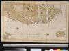
Oud Groenland van Staaten Hoek of C. Farawel tot de Visch Baij of Straet Davids int groot
Greenland Gerard van Keulen
Discoveries in the Arctic Sea between Baffin Bay & Melville Island
1 : 2600000 Arktida Arrowsmith, John John Arrowsmith
Feuille 2 (B I), uit: Carte géologique internationale de l'Europe : la carte, votée au congrès géologique international de Bologne en 1881, est exécutée conformément aux décisions d'une commission internationale, avec le concours des gouvernements, sous le dir. de M.M. Beyrich et Hauchecorne
Annotatie: Blad 48 gamme des couleurs; blad 49: bladwijzer en titelblad Heinrich Ernst Beyrich 1815-1896; Wi. Hauchecorne Berlin : Reimer / (Berlin: Institut lithographique)
Carta delle Terre polari Artiche dalla Baja di Baffin all'Isola Baring
1 : 2800000 arktická oblast Miniscalchi-Erizzo, Francesco
Fishing Chart. Greenland & the Davis Strait
Fishing Chart. Greenland & the Davis Strait. Compiled from the latest Danish information. Corrected to 29.11.1952. Chart no. 020. -- Insets: Approaches to Upernivik. Upernivik. Umanak. Godhavn, Jakobshavn, Holsteinsborg, Christianshaab, Holsteinsborg Havn. Approaches to Godthaabs Fjord. Disko Bay. Egedesminde Havn. Egedesminde. Sukkertoppen Havn. Approaches to Sukkertoppen. Godthaab & Skibshavn. Frederiskhaab. Frederikshaab Havn. Approach to Faeringerhavnen. Faeringerhavnen. Julianehaab. Approach to Julianehaab. Arsuk Fiord. St. Ives, Hunts : Imray, Laurie, Norie & Wilson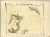
Decouvertes Boreales. Amer. Sep. 9.
1 : 1641836 Vandermaelen, Philippe, 1795-1869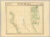
Detroit de Davis. Amer. Sep. 10.
1 : 1641836 Vandermaelen, Philippe, 1795-1869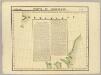
Partie de Groenland. Amer. Sep. 11.
1 : 1641836 Vandermaelen, Philippe, 1795-1869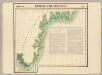
Groenland Oriental. Amer. Sep. 20.
1 : 1641836 Vandermaelen, Philippe, 1795-1869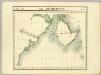
Ile Southampton. Amer. Sep. 17.
1 : 1641836 Vandermaelen, Philippe, 1795-1869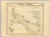
Detroit d'Hudson. Amer. Sep. 18.
1 : 1641836 Vandermaelen, Philippe, 1795-1869