Maps of Nunavut

Septemtrionaliora Americæ à Groenlandia, per freta Davidis et Hudson, ad Terram Novam
1 Karte : Kupferdruck ; 48 x 55 cm Renard Louis Renard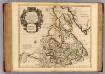
Canada, Nouvelle France.
1 : 9000000 L'Isle, Guillaume de, 1675-1726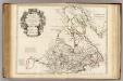
Canada, Nouvelle France.
1 : 9000000 L'Isle, Guillaume de, 1675-1726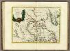
La Baja D'Hudson Terra di Labrador e Groenlandia.
1 : 9750000 Zatta, Antonio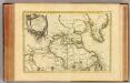
L'Amerique Septentrionale 1.
1 : 10050000 Bonne, Rigobert, 1727-1794
[142][145] Septemtrionaliora Americae à Groenlandia, ..., uit: Atlas sive Descriptio terrarum orbis
Annotatie: Gedigitaliseerde versie. Amsterdam. Heiloo : Picturae (vervaardiger), 2015. tiff-bestand. Gedigitaliseerd: 07-01-2015; Origineel: Universiteitsbibliotheek Vrije Universiteit (XL.05127.-) ; Netherlands; Titelpagina ontbreekt Wit, Frederik de Amsterdam : Frederick de Wit
A General Chart ... Davis Straits & Baffin Islands Bay.
1 : 19000000 Melish, John
Carte marine, de la B. de Baffin, et une partie d'Hudson, d'Island et Groenland
1 Karte : Kupferdruck ; 42 x 48 cm Königliche Akademie der Wissenschaften
Greenland, Labrador.
1 : 15000000 Peterson, Augusts
The north west part of America / by Robt. Morden.; Geography rectified, or, A description of the world: in all its kingdoms, provinces, countries, islands, cities, towns, seas, rivers, bayes, capes, ports: their antient and present names, inhabitants, situations, histories, customs, governments, &c.: as also their commodities, coins, weights, and measures, compared with those at London: illustrated with above sixty new maps: the whole work performed according to the more accurate discoveries of modern authors / by Robert Morden.
from Geography rectified, or, A description of the world : in all its kingdoms, provinces, countries, islands, cities, towns, seas, rivers, bayes, capes, ports : their antient and present names, inhabitants, situations, histories, customs, governments, &c. : as also their commodities, coins, weights, and measures, compared with those at London : illustrated with above sixty new maps : the whole work performed according to the more accurate discoveries of modern authors / by Robert Morden. Morden, Robert; Cockerill, Thomas,
Paskaert van de Noordelijckste kuste van America van Groenland door de Straet Davis en de Straet Hudson tot Terra Neuf
1 : 8000000 Colom, Jacob Aertsz Colom, Jacob Aertsz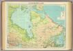
North-eastern Canada.
1 : 5000000 John Bartholomew and Son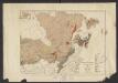
Geology. East sheet
1 : 6336000
North America polar regions : Baffin Bay to Lincoln Sea showing the most recent discoveries including those of U.S.S. Polaris Expedition in 1871-2, under Captain C.F. Hall, British Arctic Expedition in 1875-6, under Captain G.S. Nares, R.N., The Lady Franklin Bay Expedition in 1881-4, under Lieutenant A.W. Greely, U.S.A
1 : 1500000 United States. Hydrographic Office Hydrographic Office, Navy Dept.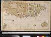
Oud Groenland van Staaten Hoek of C. Farawel tot de Visch Baij of Straet Davids int groot
Greenland Gerard van Keulen
Baffin Bay journey.
1 : 3200000 Hayes, Isaac Israel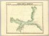
Decouvertes Boreales. Amer. Sep. 2.
1 : 1641836 Vandermaelen, Philippe, 1795-1869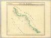
Baie de Baffin. Amer. Sep. 3.
1 : 1641836 Vandermaelen, Philippe, 1795-1869
Karten-Skizze des Treibeises bei Newfundland während der Zeit vom 11. März bis zum 5. Mai 1891, nach den Berichten, welche bis zum 20. Mai eingegangen sind
Newfoundland (Kanada : ostrov)
Karten-Skizze des Treibeises bei Newfundland während der Zeit von Anfang Mai bis Ende Juni, nach den Berichten, welche bis zum 8ten Juli eingegangen sind
Newfoundland (Kanada : ostrov)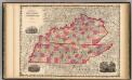
Kentucky And Tennessee.
1 : 1520640 Johnson, A.J.
A new map of the province of Quebec in North America, drawn from the best authorities
1 : 6500000
Discoveries in the Arctic Sea between Baffin Bay & Melville Island
1 : 2600000 Arktida Arrowsmith, John John Arrowsmith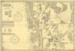
Fishing Chart. Greenland & the Davis Strait
Fishing Chart. Greenland & the Davis Strait. Compiled from the latest Danish information. Corrected to 29.11.1952. Chart no. 020. -- Insets: Approaches to Upernivik. Upernivik. Umanak. Godhavn, Jakobshavn, Holsteinsborg, Christianshaab, Holsteinsborg Havn. Approaches to Godthaabs Fjord. Disko Bay. Egedesminde Havn. Egedesminde. Sukkertoppen Havn. Approaches to Sukkertoppen. Godthaab & Skibshavn. Frederiskhaab. Frederikshaab Havn. Approach to Faeringerhavnen. Faeringerhavnen. Julianehaab. Approach to Julianehaab. Arsuk Fiord. St. Ives, Hunts : Imray, Laurie, Norie & Wilson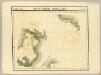
Decouvertes Boreales. Amer. Sep. 9.
1 : 1641836 Vandermaelen, Philippe, 1795-1869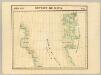
Detroit de Davis. Amer. Sep. 10.
1 : 1641836 Vandermaelen, Philippe, 1795-1869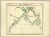
Ile Southampton. Amer. Sep. 17.
1 : 1641836 Vandermaelen, Philippe, 1795-1869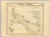
Detroit d'Hudson. Amer. Sep. 18.
1 : 1641836 Vandermaelen, Philippe, 1795-1869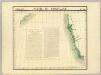
Partie du Groenland. Amer. Sep. 19.
1 : 1641836 Vandermaelen, Philippe, 1795-1869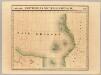
Partie, Nouvelle Bretagne. Amer. Sep. 27.
1 : 1641836 Vandermaelen, Philippe, 1795-1869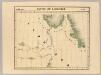
Partie du Labrador. Amer. Sep. 28.
1 : 1641836 Vandermaelen, Philippe, 1795-1869