Maps of Cumberland Peninsula
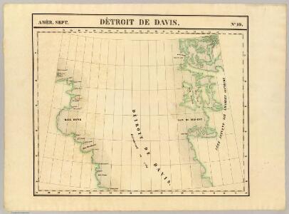
Detroit de Davis. Amer. Sep. 10.
1 : 1641836 Vandermaelen, Philippe, 1795-1869
Nieuwe afteekening van t Land om de Noordt in de Straet Davids boven t eijland Disko
Greenland Johannes Schuringa Gerard van Keulen
Grenlandia zachodnia
1 : 50000 Grónsko Wojskowy instytut geograficzny
Karte der Karajak-Eisströme, ihres Nährgebietes und ihres Vorlandes
1 : 50000 Drygalski, Erich von Giesecke & Devrient
Fishing Chart. Greenland & the Davis Strait
Fishing Chart. Greenland & the Davis Strait. Compiled from the latest Danish information. Corrected to 29.11.1952. Chart no. 020. -- Insets: Approaches to Upernivik. Upernivik. Umanak. Godhavn, Jakobshavn, Holsteinsborg, Christianshaab, Holsteinsborg Havn. Approaches to Godthaabs Fjord. Disko Bay. Egedesminde Havn. Egedesminde. Sukkertoppen Havn. Approaches to Sukkertoppen. Godthaab & Skibshavn. Frederiskhaab. Frederikshaab Havn. Approach to Faeringerhavnen. Faeringerhavnen. Julianehaab. Approach to Julianehaab. Arsuk Fiord. St. Ives, Hunts : Imray, Laurie, Norie & Wilson
Cumberland Isle from the observations of Captain Penny
Cumberland Isle from the observations of Captain Penny, and from the ínformation of Enoolooapeck, an intelligent Esquimaux, 1839. [Admiralty Chart] [London]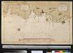
Afteekening van Oud Groenland in de Straet Davids
Greenland Bruijn, Ockkers & Groeneveld Gerard van Keulen
[142][145] Septemtrionaliora Americae à Groenlandia, ..., uit: Atlas sive Descriptio terrarum orbis
Annotatie: Gedigitaliseerde versie. Amsterdam. Heiloo : Picturae (vervaardiger), 2015. tiff-bestand. Gedigitaliseerd: 07-01-2015; Origineel: Universiteitsbibliotheek Vrije Universiteit (XL.05127.-) ; Netherlands; Titelpagina ontbreekt Wit, Frederik de Amsterdam : Frederick de Wit
Gletscherkarte.
Berghaus, Hermann
The north west part of America / by Robt. Morden.; Geography rectified, or, A description of the world: in all its kingdoms, provinces, countries, islands, cities, towns, seas, rivers, bayes, capes, ports: their antient and present names, inhabitants, situations, histories, customs, governments, &c.: as also their commodities, coins, weights, and measures, compared with those at London: illustrated with above sixty new maps: the whole work performed according to the more accurate discoveries of modern authors / by Robert Morden.
from Geography rectified, or, A description of the world : in all its kingdoms, provinces, countries, islands, cities, towns, seas, rivers, bayes, capes, ports : their antient and present names, inhabitants, situations, histories, customs, governments, &c. : as also their commodities, coins, weights, and measures, compared with those at London : illustrated with above sixty new maps : the whole work performed according to the more accurate discoveries of modern authors / by Robert Morden. Morden, Robert; Cockerill, Thomas,
Paskaert van de Noordelijckste kuste van America van Groenland door de Straet Davis en de Straet Hudson tot Terra Neuf
1 : 8000000 Colom, Jacob Aertsz Colom, Jacob Aertsz
Old Greenland.
1 : 9850000 Bowen, Emanuel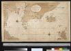
Nieuwe afteekening van de Straat Davits van Hitland tot aen de Straet Davids
Atlantic Ocean Gerard van Keulen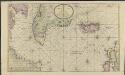
Nieuwe platte pas kaart van de Noord Occiaan van Hitland tot in de Straat Davids seer dienstig voor de Straat Davids vaarders
1 : 3800000 welke straat nu nieulijks en naaukeurig afgeteekent en beschreeven door schipper Laurens Feykes Haan en verder in 't ligt gebragt door G. van Keulen Tot Amsterdam : bij Gerard van Keulen, boek en zee-kaart verkooper, aan de Nieuwen-brug [...]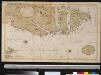
Oud Groenland van Staaten Hoek of C. Farawel tot de Visch Baij of Straet Davids int groot
Greenland Gerard van Keulen
Greenland, Labrador.
1 : 15000000 Peterson, Augusts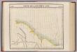
Partie, Russie d'Asie. Asie 11.
1 : 1641836 Vandermaelen, Philippe, 1795-1869
Septemtrionaliora Americæ à Groenlandia, per freta Davidis et Hudson, ad Terram Novam
1 Karte : Kupferdruck ; 48 x 55 cm Renard Louis Renard
Vorstellung des Meers in Norden von Asien und America, nebst der Berechnung von dessen Grösse und Ausdehnung
Asie severní
L'Amerique Septentrionale 1.
1 : 10050000 Bonne, Rigobert, 1727-1794
Carte marine, de la B. de Baffin, et une partie d'Hudson, d'Island et Groenland
1 Karte : Kupferdruck ; 42 x 48 cm Königliche Akademie der Wissenschaften
Gletscherkarte
Atlas der Geologie Zittel, K.v. ; Berghaus, Hermann Justus Perthes
Typus Maritimus Groenlandiae, Islandiae, Freti Davidis, Insulae Iohannis Mayen, et Hitlandiae, Scotiae, et Hiberniae litora maritima Septentrionalia
1 : 7000000 Annotatie: Paskaart van de noordelijke Atlantische Oceaan met de kusten van met name het gebied tussen de Faeroër Eilanden, Groenland en Baffin Island; Origineel is Blad 149 in atlas factice; Kaart bevat diverse kompasrozen en is gedecoreerd met afbeeldingen van schepen en een walvis; Annotatie geografische gegevens: Met drie schaalstokken [Amstelodami] : [Apud Ioannem Ianßonium]
A General Chart ... Davis Straits & Baffin Islands Bay.
1 : 19000000 Melish, John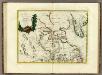
La Baja D'Hudson Terra di Labrador e Groenlandia.
1 : 9750000 Zatta, Antonio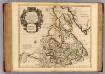
Canada, Nouvelle France.
1 : 9000000 L'Isle, Guillaume de, 1675-1726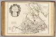
Canada, Nouvelle France.
1 : 9000000 L'Isle, Guillaume de, 1675-1726
Groenland und die angraenzenden Laender nach den Charten und Berichten von Cranz, Egede, Gieseke, Graah, Olavsen, Parry, Ross, Scoresby, Thorhallesen u.a.
1 : 5000000 entworfen und gezeichnet von Theodor Gliemann Weimar : Verlag des Geograph. Instituts
Pas-caerte van Groenlandt, Yslandt, Straet Davids en Ian Mayen Eylant
1 Karte : Kupferdruck ; 43 x 52 cm Doncker bÿ Hendrick Doncker boekverkoper en graadbooghmaker inde Nieubrughsteegh