Maps of Deccan Plateau

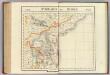
The Carnatic, Etc.
1 : 3380000 Sharpe, J.
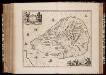
Peninsula Indiæ citra Gangem, hoc est, orae celeberrimae Malabar & Coromandel cum adjacente insula non minus celebratissima Ceylon
1 Karte : Kupferdruck ; 53 x 47 cm L'Isle Homännische Erben
The Southern Railway

Sheet D [South India], uit: Road map of India
1 : 2027520 titelvariant: North West India; Central & North India; North East India; South India; Annotatie geografische gegevens: De bladen overlappen elkaar gedeeltelijk; Elk blad met bladoverzicht van de hele serie [S.l. : India Tyre & Rubber Company]
Composite: India peninsula.
1 : 1300000 Faden, William, 1750?-1836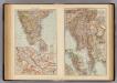
India South, Burma, Malay Peninsula.
1 : 6000000 Andree, Richard; Times (London, England)
India 2.
1 : 2217600 Letts, Son & Co.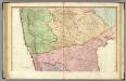
India peninsula N.
1 : 1300000 Faden, William, 1750?-1836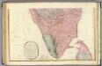
India peninsula S.
1 : 1300000 Faden, William, 1750?-1836
Ostindisches Missionsgebiet der evan.miss.gesellschaft in Basel

India II. Madras Presidency.
1 : 2200000 Society for the Diffusion of Useful Knowledge (Great Britain)
Mysore State (Vishal Karnatak)

Map of the Malabar District
Hyderabad et Mysore. Asie 103.
1 : 1641836 Vandermaelen, Philippe, 1795-1869
India 3.
1 : 2217600 Letts, Son & Co.
India III. Bombay Presidency.
1 : 2200000 Society for the Diffusion of Useful Knowledge (Great Britain)
Mangalore und Aussenstationen
Breidenbach, M.
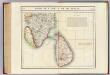
India I and Ceylon. Published under the Superintendence of the Society for the Diffusion of Useful Knowledge.

Coromandel.
1 : 780000 Anville, Jean Baptiste Bourguignon d, 1697-1782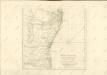

Koromandel
1 : 930000 Indie Anville, Jean-Baptiste Bourguinon d' Schraembl, Franz Anton F.A. Schraembl
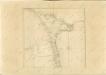
General Map of the Bombay Presidency

Plan of the Station and Town of Dharwar.
Huber, J.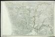
[Indian Atlas] Sheet 62
Partie, l'Inde et Ceylan. Asie 108.
1 : 1641836 Vandermaelen, Philippe, 1795-1869
India 1.
1 : 2217600 Letts, Son & Co.
India I and Ceylon.
1 : 2200000 Society for the Diffusion of Useful Knowledge (Great Britain)
Insula Ceilon et Madura
1 : 1000000 exactissime delineata et nuperrime edita per R. & J. Ottens [Amsterdam] : [Ottens]