Maps of Karnataka

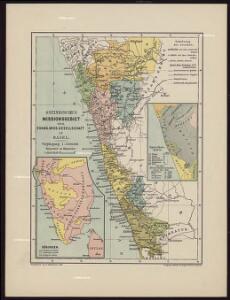
Ostindisches Missionsgebiet der evan.miss.gesellschaft in Basel

Composite: India peninsula.
1 : 1300000 Faden, William, 1750?-1836
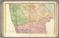
India 2.
1 : 2217600 Letts, Son & Co.
Mysore State (Vishal Karnatak)

India II. Madras Presidency.
1 : 2200000 Society for the Diffusion of Useful Knowledge (Great Britain)
Map of the Malabar District
India peninsula N.
1 : 1300000 Faden, William, 1750?-1836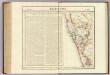
Bejapoor. Asie 102.
1 : 1641836 Vandermaelen, Philippe, 1795-1869
General Map of the Bombay Presidency

Plan of the Station and Town of Dharwar.
Huber, J.
Atlas der evangelischen Missionsgesellschaft in Basel mit Angabe der Verbreitung der Hauptreligionen7.Nord-Kanara
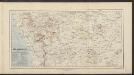
Süd Mahratta
Atlas der evangelischen Missions-Gesellschaft zu Basel Locher; Gross, Rudolf Im Verlag des Comptoires der evangelischen Missions-Gesellschaft
Bijapur Collectorate

South Kanara

Nord-Kanara
Atlas der evangelischen Missions-Gesellschaft zu Basel Locher; Gross, Rudolf Im Verlag des Comptoires der evangelischen Missions-Gesellschaft
Malabar und die Nilagiri od. blaue Berge
Atlas der evangelischen Missions-Gesellschaft zu Basel Locher; Gross, Rudolf Im Verlag des Comptoires der evangelischen Missions-Gesellschaft
South Canara District

Süd -Canara
Atlas der evangelischen Missions-Gesellschaft zu Basel Locher; Gross, Rudolf Im Verlag des Comptoires der evangelischen Missions-Gesellschaft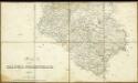
Map of the Dharwar Collectorate 1897

Arbeitsgebiet der Basler Missions Station Calicut
G. Peter
Survey of the bounderies of Purgunna of Bangalore
Maps described in the 1878 published catalogue
Plan von Bijapur.
Huber, J.
Secunderbad & Bolarum, 3 inch military map
India Office reference collection of maps Survey of India
Secundarabad & Bolarum
Secunderábád & Bolárum. Second edition. [Calcutta] : Survey of India Offices (P.L.O.)
Plan von Udapi
Hafner, J.
Missions-Compound in Hubly und nächste Umgebung.
Huber, J.
Goa Indiae orientalis metropolis
Velha Góa (Indie) Hollar, Václav
Anandapur Markung
Eckelmann, O.
Situationsplan [von Anandapur]
Eckelmann, O.