Maps of Solapur

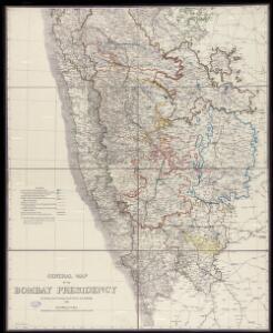
General Map of the Bombay Presidency

Plan of the Station and Town of Dharwar.
Huber, J.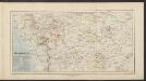
Süd Mahratta
Atlas der evangelischen Missions-Gesellschaft zu Basel Locher; Gross, Rudolf Im Verlag des Comptoires der evangelischen Missions-Gesellschaft
Bijapur Collectorate

Atlas der evangelischen Missionsgesellschaft in Basel mit Angabe der Verbreitung der Hauptreligionen7.Nord-Kanara

Nord-Kanara
Atlas der evangelischen Missions-Gesellschaft zu Basel Locher; Gross, Rudolf Im Verlag des Comptoires der evangelischen Missions-Gesellschaft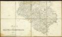
Map of the Dharwar Collectorate 1897

Bombay (Harbour) (1885)
India. West Coast. Bombay Harbour. Chiefly from surveys ... 1881-2. 1 sea mile[ = 50 mm] London : Admiralty
Bombay, No 47 B/13
India Office reference collection of maps Survey of India
Bombay
1 : 62000 Bombaj (Indie) Surveyor general of India
Plan von Bijapur.
Huber, J.
Map of the Island of Bombay

India. West Coast(1935)
[India. West Coast. Port of Bombay. Surveyed ... 1892-3. Natural Scale, 1 : 12,100]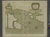
A new mapp of the Island of BOMBAY and SALLSET
from The sea-atlas : containing an hydrographical description of most of the sea-coasts of the known parts of the world.
Missions-Compound in Hubly und nächste Umgebung.
Huber, J.
Goa Indiae orientalis metropolis
Velha Góa (Indie) Hollar, Václav
Bombay and surrounding country
1 : 126720 Bombaj (Indie) Survey of India offices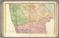
India peninsula N.
1 : 1300000 Faden, William, 1750?-1836
Ostindisches Missionsgebiet der evan.miss.gesellschaft in Basel

India 3.
1 : 2217600 Letts, Son & Co.
India III. Bombay Presidency.
1 : 2200000 Society for the Diffusion of Useful Knowledge (Great Britain)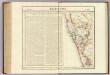
Bejapoor. Asie 102.
1 : 1641836 Vandermaelen, Philippe, 1795-1869
Mangalore und Aussenstationen
Breidenbach, M.
Mysore State (Vishal Karnatak)

Composite: India peninsula.
1 : 1300000 Faden, William, 1750?-1836
Sheet D [South India], uit: Road map of India
1 : 2027520 titelvariant: North West India; Central & North India; North East India; South India; Annotatie geografische gegevens: De bladen overlappen elkaar gedeeltelijk; Elk blad met bladoverzicht van de hele serie [S.l. : India Tyre & Rubber Company]
S. Hindostan.
1 : 3000000 Thomson, John
India - southern section.
1 : 4000000 John Bartholomew & Co.
Peninsula Indiae citra Gangem hoc est orae celeberrimae Malabar & Coromandel cum adjacente insula non minus celebratissima Ceylon
1 : 3000000 Indie studio Homannianorum Heredum
Peninsula INDIAE citra Gangem, hoc est Orae celeberrimae MALABAR & COROMANDEL Cum adjacente Insula non minus celebratissima CEYLON
1 : 3000000 Ganga-oblast (Indie a Bangladéš) Delisle, Guillaume studio Homannianorum Heredum