Maps of Puducherry

India 2.
1 : 2217600 Letts, Son & Co.
India II. Madras Presidency.
1 : 2200000 Society for the Diffusion of Useful Knowledge (Great Britain)
Ostindisches Missionsgebiet der evan.miss.gesellschaft in Basel
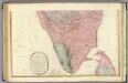
India peninsula S.
1 : 1300000 Faden, William, 1750?-1836
Mysore State (Vishal Karnatak)
[Indian Atlas] Sheet 62

Coromandel.
1 : 780000 Anville, Jean Baptiste Bourguignon d, 1697-1782
Koromandel
1 : 930000 Indie Anville, Jean-Baptiste Bourguinon d' Schraembl, Franz Anton F.A. Schraembl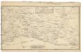
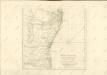
Theatre de la guerre dans Linde [sic] sur la côte de Coromandel
1 : 705000 Indie jižní
Atlas der evangelischen Missionsgesellschaft in Basel mit Angabe der Verbreitung der Hauptreligionen7.Nord-Kanara

South Kanara

Plan of the Station and Town of Dharwar.
Huber, J.
Nord-Kanara
Atlas der evangelischen Missions-Gesellschaft zu Basel Locher; Gross, Rudolf Im Verlag des Comptoires der evangelischen Missions-Gesellschaft
Malabar und die Nilagiri od. blaue Berge
Atlas der evangelischen Missions-Gesellschaft zu Basel Locher; Gross, Rudolf Im Verlag des Comptoires der evangelischen Missions-Gesellschaft
South Canara District

Süd -Canara
Atlas der evangelischen Missions-Gesellschaft zu Basel Locher; Gross, Rudolf Im Verlag des Comptoires der evangelischen Missions-Gesellschaft
Jaghir Lands.
1 : 250000 Robert Laurie & James Whittle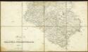
Map of the Dharwar Collectorate 1897

Arbeitsgebiet der Basler Missions Station Calicut
G. Peter
Survey of the bounderies of Purgunna of Bangalore
Maps described in the 1878 published catalogue
Plan von Udapi
Hafner, J.
Sketch plan of the attack on Seringapatam (Mysore)
Pencil, pen-and-ink and wash with water-colour sketch plan of the attack on Seringapatam by an unknown artist, dated 1791. Srirangapatnam is an island set in the River Kaveri in the modern-day state of Karnataka in the south west of India. The Vijayanagara rulers built a fort here in 1454 and in 1616 it became the capital of the Mysore Wadayar Rajas. Later it was the capital of the renowned Rajas of Mysore, Haidar Ali (c. 1722-1782) and Tipu Sultan (1753-1799). The Rajas were responsible for turning the small state of Mysore into a major Muslim power. Haider Ali faced opposition from the Marathas, the Nizam of Hyderabad and the British. Four successive wars were fought for control of southern India. In 1781 Haidar was defeated and died a year later but the military campaign was continued by his son, Tipu. The final battle took place in May 1799 when the British stormed the fortress and Tipu Sultan was killed.
Plan exhibiting the Several Anchorages in the Madras Roads

Map of Porto Novo
Pen and ink and watercolour Map of Parangipettai (Porto Novo) by John Mustie (fl. 1817) Mustie, John (fl. 1817), Artist
Map of Porto Novo on a larger scale
Pen and ink and watercolour map of Parangipettai (Porto Novo) in Tamil Nadu by John Mustie (fl. 1817). Mustie, John (fl. 1817), Artist
Missions-Compound in Hubly und nächste Umgebung.
Huber, J.
Goa Indiae orientalis metropolis
Velha Góa (Indie) Hollar, Václav
Anandapur Markung
Eckelmann, O.


