Maps of Tamil Nadu
Theatre de la guerre dans Linde [sic] sur la côte de Coromandel
1 : 705000 Indie jižní
The Church Missionary Atlas. New and enlarged Edition (the seventh). Part II. IndiaMap of the Tinnevelly District

Jaghir Lands.
1 : 250000 Robert Laurie & James Whittle
Survey of the bounderies of Purgunna of Bangalore
Maps described in the 1878 published catalogue
Sketch plan of the attack on Seringapatam (Mysore)
Pencil, pen-and-ink and wash with water-colour sketch plan of the attack on Seringapatam by an unknown artist, dated 1791. Srirangapatnam is an island set in the River Kaveri in the modern-day state of Karnataka in the south west of India. The Vijayanagara rulers built a fort here in 1454 and in 1616 it became the capital of the Mysore Wadayar Rajas. Later it was the capital of the renowned Rajas of Mysore, Haidar Ali (c. 1722-1782) and Tipu Sultan (1753-1799). The Rajas were responsible for turning the small state of Mysore into a major Muslim power. Haider Ali faced opposition from the Marathas, the Nizam of Hyderabad and the British. Four successive wars were fought for control of southern India. In 1781 Haidar was defeated and died a year later but the military campaign was continued by his son, Tipu. The final battle took place in May 1799 when the British stormed the fortress and Tipu Sultan was killed.
Plan exhibiting the Several Anchorages in the Madras Roads

Map of Porto Novo
Pen and ink and watercolour Map of Parangipettai (Porto Novo) by John Mustie (fl. 1817) Mustie, John (fl. 1817), Artist
Map of Porto Novo on a larger scale
Pen and ink and watercolour map of Parangipettai (Porto Novo) in Tamil Nadu by John Mustie (fl. 1817). Mustie, John (fl. 1817), Artist
Two fragments of a map showing locations of temples at Mahabalipuram
Two fragments of a map in watercolour with pen and ink showing locations of temples at Mamallapuram, from an Album of 37 drawings and plans of the temples and sculptures at Mamallapuram, c. 1816. Colin MacKenzie (1754-1821) joined the East India Company as an engineer at the age of 28 and spent the majority of his career in India. He used the salary he earned from his military career as a captain, major and finally a colonel to finance his research into the history and religion of Indian culture. During his surveys he collected and recorded details concerning every aspect of Indian architecture, language and religion, resulting in thousands of drawings and copies of inscriptions. Mamallapuram, a tiny village south of Chennai (Madras), was a flourishing port of the Pallava dynasty from the 5th - 8th centuries. The site is famous for a group of temples, a series of rock-cut caves and monolithic sculptures that were most likely created in the 7th century reign of Narasimhavarman Mahamalla.
Bangalore (1935)
Far East ... Illustrated with 32 photographs [including portraits]. MUNDAY, Madeleine C. London : Stanley Paul & Co.
India peninsula S.
1 : 1300000 Faden, William, 1750?-1836
Composite: India peninsula.
1 : 1300000 Faden, William, 1750?-1836
India 2.
1 : 2217600 Letts, Son & Co.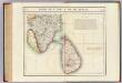
Partie, l'Inde et Ceylan. Asie 108.
1 : 1641836 Vandermaelen, Philippe, 1795-1869
India I and Ceylon. Published under the Superintendence of the Society for the Diffusion of Useful Knowledge.

India II. Madras Presidency.
1 : 2200000 Society for the Diffusion of Useful Knowledge (Great Britain)
Duodecima Asiae Tabula [Taprobana] [Karte], in: Claudii Ptolemei viri Alexandrini mathematice discipline philosophi doctissimi geographie opus [...], S. 225.
1 Karte aus Atlas Waldseemüller, Martin [und Ptolemaeus, Claudius] Übelin, Georg
Tabula Asiae XII. [Karte], in: Geographia universalis vetus et nova complectens Claudii Ptolemaei Alexandrini enarrationis libros VIII, S. 299.
1 Karte aus Atlas Münster, Sebastian [und Ptolemaeus, Claudius]
Coromandel.
1 : 780000 Anville, Jean Baptiste Bourguignon d, 1697-1782
India 1.
1 : 2217600 Letts, Son & Co.
India I and Ceylon.
1 : 2200000 Society for the Diffusion of Useful Knowledge (Great Britain)
[Duodecima Asie tabula] [Karte], in: Clavdii Ptholomei Viri Alexandrini Cosmographie, S. 191.
1 Karte aus Atlas Nicolaus Germanus [und Ptolemaeus, Claudius]
[Indian Atlas] Sheet 62

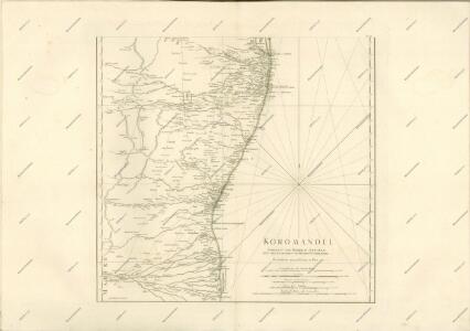
Koromandel
1 : 930000 Indie Anville, Jean-Baptiste Bourguinon d' Schraembl, Franz Anton F.A. Schraembl
Tabula Asiae XII. [Karte], in: Claud. Ptolemaeus. Geographia lat. cum mappis [...], S. 329.
1 Karte aus Atlas Münster, Sebastian [und Ptolemaeus, Claudius]
Insula Ceilon et Madura
1 : 1000000 exactissime delineata et nuperrime edita per R. & J. Ottens [Amsterdam] : [Ottens]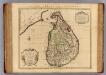
l'Isle de Ceylan.
1 : 1250000 L'Isle, Guillaume de, 1675-1726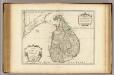
l'Isle de Ceylan.
1 : 1250000 L'Isle, Guillaume de, 1675-1726