Maps of Tver
U.S.S.R. in Europe - Central. Pergamon World Atlas.
1 : 2500000 Polish Army Topography Service
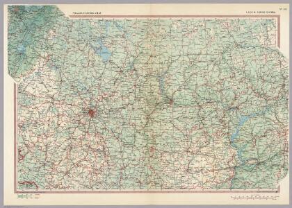
19-20. RSFSR (Russian Soviet Federated Socialist Republic) in Europe, Central. The World Atlas.
1 : 3000000 USSR (Union of Soviet Socialist Republics).
Voenno-dorožnaja karta časti Rossii i pograničnych zemelʹ
1 : 1680000 Zentralrussland, Moskau Šubert [Generalmajor]
[Ost-Europa, Blatt 4]
Adolf Stieler's Handatlas über alle Theile der Erde und über das Weltgebäude Stieler, Adolf Justus Perthes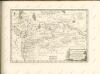

Anfänge des Moskauer Reiches
1 : 8250000 Moskauer Reich
Governi di Moscovia e Woronez colle loro provincie nella Russia europea
1 Karte : Kupferdruck ; 41 x 32 cm Zatta; Zuliani; Pitteri presso Antonio Zatta
Governi di Moscovia e Woronez colle loro provincie nella Russia europea / G. Zuliani inc. ; G. Pitte
1 : 3500000 1 Karte : Kupferdruck ; 41 x 32 cm Zuliani, Giuliano presso Antonio Zatta
I governi di Moscovia e Woronez nell'impero della Russia in Europa / Gio. Ma. Cassini som.co. inc.
1 : 3500000 1 Karte : Kupferdruck ; 44 x 31 cm Cassini, Giovanni Maria Presso la Calcografia Camerale
Partie, Russie d'Europe. Europe 10.
1 : 1641836 Vandermaelen, Philippe, 1795-1869
Feuille 19 (E III), uit: Carte géologique internationale de l'Europe : la carte, votée au congrès géologique international de Bologne en 1881, est exécutée conformément aux décisions d'une commission internationale, avec le concours des gouvernements, sous le dir. de M.M. Beyrich et Hauchecorne
Annotatie: Blad 48 gamme des couleurs; blad 49: bladwijzer en titelblad Heinrich Ernst Beyrich 1815-1896; Wi. Hauchecorne Berlin : Reimer / (Berlin: Institut lithographique)
Tableau des opérations de la Grande Armée depuis le 8 Aout jusqu'au 20 8bre 1812 (marche de Smolensk à Moscou)
1 : 2300000 Et.ne Henry del. et sculpt.
Feuille 20 (F III), uit: Carte géologique internationale de l'Europe : la carte, votée au congrès géologique international de Bologne en 1881, est exécutée conformément aux décisions d'une commission internationale, avec le concours des gouvernements, sous le dir. de M.M. Beyrich et Hauchecorne
Annotatie: Blad 48 gamme des couleurs; blad 49: bladwijzer en titelblad Heinrich Ernst Beyrich 1815-1896; Wi. Hauchecorne Berlin : Reimer / (Berlin: Institut lithographique)
Zasěčnyja čerty.
Russland Krieg
Russia Part lV.
1 : 1770000 Society for the Diffusion of Useful Knowledge (Great Britain)
Russia 4.
1 : 1900800 Letts, Son & Co.
NOVA & ACCVRATA | WOLGÆ FLVMINIS
olim RHA dicti, | DELINEATIO | Auctore | ADAMO OLEARIO. [Amsterdam : Joan Blaeu]
Moskowisch-Litthauisches Grenzgebiet
1 : 6000000 Polen-Litauen, Moskauer Reich, Grenze
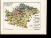
Karta srednerusskoj černozemnoj oblasti
Russland Zentralrussland Topografie
Nova Et Accurata Wolgae Fluminis, olim RHA dicti Delineatio [Karte, Teil 1], in: Novus atlas absolutissimus, Bd. 1, S. 87.
1 Karte aus Atlas Janssonius Offizin
Im Stillstand von Deulino 1618 an Polen abgetretene Gebiete
1 : 8250000 Moskauer Reich Polnisch-Russischer Krieg <1609-1618>, Gebietsverlust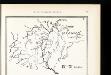
Srednerusskaja černozemnaja oblast' v IX-XIII v.v: IX-XI věka
Russland Zentralrussland
Srednerusskaja černozemnaja oblast' v IX-XIII v.v: XI-XIII věka
Russland Zentralrussland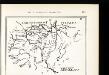
Srednerusskaja černozemnaja oblast' v XIV-XVII v.v: XIV-XV věka
Russland Zentralrussland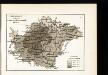
Raspachannost zemel' srednerusskoj černozemnoj oblasti
Russland Zentralrussland Bodenertrag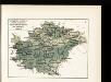
Raspredělenīe temperatury v janvarě i količestva osadkov zimoju v srednerusskoj černozemnoj oblasti
Russland Zentralrussland Klima Temperatur Januar
Partie, Russie d'Europe. Europe 11.
1 : 1641836 Vandermaelen, Philippe, 1795-1869
Ljudnost' selenīj v srednerusskoj černozemnoj oblasti
Russland Zentralrussland Bevölkerung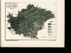
Raspredělenīe temperatury v ījulě i količestva osadkov zimoju v srednerusskoj černozemnoj oblasti
Russland Zentralrussland Klima Temperatur Juli