Maps of Tver

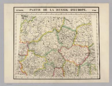
Partie, Russie d'Europe. Europe 10.
1 : 1641836 Vandermaelen, Philippe, 1795-1869
Feuille 19 (E III), uit: Carte géologique internationale de l'Europe : la carte, votée au congrès géologique international de Bologne en 1881, est exécutée conformément aux décisions d'une commission internationale, avec le concours des gouvernements, sous le dir. de M.M. Beyrich et Hauchecorne
Annotatie: Blad 48 gamme des couleurs; blad 49: bladwijzer en titelblad Heinrich Ernst Beyrich 1815-1896; Wi. Hauchecorne Berlin : Reimer / (Berlin: Institut lithographique)
Anfänge des Moskauer Reiches
1 : 8250000 Moskauer Reich
Russia 4.
1 : 1900800 Letts, Son & Co.
Russia Part lV.
1 : 1770000 Society for the Diffusion of Useful Knowledge (Great Britain)
RVSSIÆ, | Vulgo MOSCOVIA dictæ, | Pars Occidentalis
Auctore Isaaco Maßa. [Amsterdam : Joan Blaeu]
Tableau des opérations de la Grande Armée depuis le 8 Aout jusqu'au 20 8bre 1812 (marche de Smolensk à Moscou)
1 : 2300000 Et.ne Henry del. et sculpt.
Moscovia
1 : 4500000 1 Karte : Kupferdruck ; 12 x 17 cm Hondius, Jodocus [Verlag nicht ermittelbar]
Moscovia
1 : 4500000 1 Karte : Kupferdruck ; 12 x 17 cm Mercator, Gerhard printed by William Stansby for Henrie Fetherstone
Karta napravlenija železnoj dorogi šossei i vodjanych soobščenij meždu S. Peterburgom i Moskvoju
1 : 1300000 Moskva-oblast (Rusko) Al'tman, I. Flerov, V. v Zavedenii kongrevskoj chromotipii F. Tuma
Obščaja geologičeskaja karta evropejskoj Rossii : List 57: Moskva, Korceva, Jurʹev, Borovsk, Egorʹevsk
1 : 420000 sostavilʹ S. Nikitin = Carte géologique générale de la Russie d'Europe : Feuille 57: Moscou, Kortschewa, Iouriév, Borovsk, Iégoriévsk dressée par S. Nikitin [S.l.] : [s.n.]
Nowgorod, Str. Russa, Ostaszkow
1 : 750000 Novgorod (Rusko) K. u. k. Militärgeographisches Institut
Die ältesten russischen Eisenhütten und -hämmer im Moskauer Gebiet
Moskau (Region) Eisenhüttenwerk
Übersichtskarte von Mittel - Europa

Schema dviženīja russkoj rati s 20 avgusta po 7 sentjabrja 1380 g.
Russland Kulikovo Pole Kulikowo Pole / Schlacht Dmitri, Moskau, Großfürst
Połock, Witebsk, Smolensk
1 : 750000 Polack (Bělorusko) K. u. k. Militärgeographisches Institut
Dwinae Fluvii. nova descriptio. [Karte, Teil 3], in: Novus atlas absolutissimus, Bd. 1, S. 81.
1 Karte aus Atlas Janssonius Offizin
Übersichtskarte von Mittel - Europa

Moskau und Umgegend
1 : 5000000 Moskau
Okrestnosti g. Rjazani i bližajšaja k nej čast' tečenīja r. Oki
Russland Zentralrussland Rjasan Oka
Tichvinskīj kanal
Russland Russland (Nord) Schifffahrtskanal Il'in', N.
Kanaly Višerskīj i Siversov
Russland Russland (Nord) Schifffahrtskanal Il'in', N.
Kanal Princa Aleksandra Virtembergskago
Russland Russland (Nord) Schifffahrtskanal Il'in', N.
Plan‘‘ sraženija pri Tarutině
Ukraine Tarutino Russlandfeldzug <1812>
Ladožskoj kanal
1 : 142000 Rusko Seutter, Matthäus Matthaeus Seutter
Aus dem Jegorjewer Kreis des Gouv. Rjasan
Russland Gouvernement Rjasan Deutsche
<Plan goroda Moskvy, s prigorodami
1 : 21000 Tipografīi͡a A.S. Suvorina Tipograf??ia? A.S. Suvorina
Plan dījstvīj pred Lubinskim sraženīem
Russland Smolensk Russlandfeldzug <1812>
<Moscow = Moskvi>
1 : 33000 Clarke, W. B Publishd under the superintendence of the Society for the Diffusion of Useful Knowledge [by] Charles Knight & Co.