Maps of Tver
U.S.S.R. in Europe - Central. Pergamon World Atlas.
1 : 2500000 Polish Army Topography Service
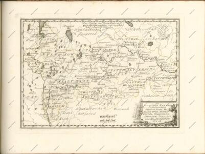
Imperii Moscovitici pars australis
1 Karte : Kupferdruck ; 48 x 57 cm Seutter; L'Isle Matthäus Seutter
Imperii Moscovitici pars australis / in lucem edita per Guillielmum de l'Isle, celeberr. regis galli
1 : 2500000 1 Karte : Kupferdruck ; 48 x 57 cm Seutter, Matthäus [Matthäus Seutter]
Imperii Moscovitici pars australis / in lucem edita per Guillielmum de l'Isle, celeberr. regis galli
1 : 2500000 1 Karte : Kupferdruck ; 48 x 57 cm Seutter, Matthäus Probst, Chalcogr.
Feuille 19 (E III), uit: Carte géologique internationale de l'Europe : la carte, votée au congrès géologique international de Bologne en 1881, est exécutée conformément aux décisions d'une commission internationale, avec le concours des gouvernements, sous le dir. de M.M. Beyrich et Hauchecorne
Annotatie: Blad 48 gamme des couleurs; blad 49: bladwijzer en titelblad Heinrich Ernst Beyrich 1815-1896; Wi. Hauchecorne Berlin : Reimer / (Berlin: Institut lithographique)
Anfänge des Moskauer Reiches
1 : 8250000 Moskauer Reich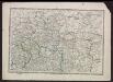
Voenno-dorožnaja karta časti Rossii i pograničnych zemelʹ
1 : 1680000 Zentralrussland, Moskau Šubert [Generalmajor]
Tableau des opérations de la Grande Armée depuis le 8 Aout jusqu'au 20 8bre 1812 (marche de Smolensk à Moscou)
1 : 2300000 Et.ne Henry del. et sculpt.
Partie, Russie d'Europe. Europe 10.
1 : 1641836 Vandermaelen, Philippe, 1795-1869
Moskowisch-Litthauisches Grenzgebiet
1 : 6000000 Polen-Litauen, Moskauer Reich, Grenze
RVSSIÆ, | Vulgo MOSCOVIA dictæ, | Pars Occidentalis
Auctore Isaaco Maßa. [Amsterdam : Joan Blaeu]
Moscovia
1 : 4500000 1 Karte : Kupferdruck ; 12 x 17 cm Hondius, Jodocus [Verlag nicht ermittelbar]
Moscovia
1 : 4500000 1 Karte : Kupferdruck ; 12 x 17 cm Mercator, Gerhard printed by William Stansby for Henrie Fetherstone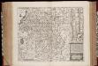
Magni Dvcatvs Lithvaniæ caeterarumq. regionum illi adiacentium exacta descrip ...
1 : 2100000 Annotatie: Rechtsboven genummerd: XVIII; Origineel is Blad 133 in atlas factice; Annotatie geografische gegevens: Met 2 schaalstokken: Milliaria Magna, Milliaria communia [Amsterdam : Sumptibus Janssonio-Waesbergior]
Zasěčnyja čerty.
Russland Krieg
Russia Part lV.
1 : 1770000 Society for the Diffusion of Useful Knowledge (Great Britain)
Im Stillstand von Deulino 1618 an Polen abgetretene Gebiete
1 : 8250000 Moskauer Reich Polnisch-Russischer Krieg <1609-1618>, Gebietsverlust
Russia 4.
1 : 1900800 Letts, Son & Co.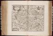
Rvssiæ, vulgo Moscovia dictæ, pars occidentalis / auctore Isaaco Maßa
1 : 2000000 Annotatie: Kaart is vervaardigd omstreeks 1638, en gepubliceerd in de Atlas Maior in 1662; Met wapen; Origineel is Blad 138 in atlas factice; Annotatie geografische gegevens: Met 2 schaalstokken Isaac Abrahamszoon Massa 1586-1643 [Amsterdam : apud Johan. et Cornelium Blaeu]
No.20. Karta Evropeyskaia Rossiia. Sheet 6
1 : 2000000 Shokalskago,Iu. M.
Srednerusskaja černozemnaja oblast' v IX-XIII v.v: XI-XIII věka
Russland Zentralrussland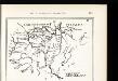
Srednerusskaja černozemnaja oblast' v XIV-XVII v.v: XIV-XV věka
Russland Zentralrussland
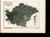
Schema dviženīja lěsnoj stichīi v step v istoričeskīja vremena
Russland Zentralrussland Bewaldung Steppe Pflanzengeografie
Ljudnost' selenīj v srednerusskoj černozemnoj oblasti
Russland Zentralrussland Bevölkerung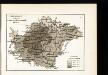
Raspachannost zemel' srednerusskoj černozemnoj oblasti
Russland Zentralrussland Bodenertrag
Obezpečennost' sel'skago naselenīja prodovol'stv. chlěbom v srednerusskoj černozemnoj oblasti
Russland Zentralrussland Landwirtschaft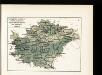
Raspredělenīe temperatury v janvarě i količestva osadkov zimoju v srednerusskoj černozemnoj oblasti
Russland Zentralrussland Klima Temperatur Januar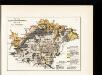
Počvy srednerusskoj černozemnoj oblasti po N. Sibircevu
Russland Zentralrussland Bodenkartierung