Maps of Tver

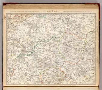
Russia Part lV.
1 : 1770000 Society for the Diffusion of Useful Knowledge (Great Britain)
Russia 4.
1 : 1900800 Letts, Son & Co.
Partie, Russie d'Europe. Europe 10.
1 : 1641836 Vandermaelen, Philippe, 1795-1869
Karta napravlenija železnoj dorogi šossei i vodjanych soobščenij meždu S. Peterburgom i Moskvoju
1 : 1300000 Moskva-oblast (Rusko) Al'tman, I. Flerov, V. v Zavedenii kongrevskoj chromotipii F. Tuma
Moscovia
1 : 4500000 1 Karte : Kupferdruck ; 12 x 17 cm Hondius, Jodocus [Verlag nicht ermittelbar]
Moscovia
1 : 4500000 1 Karte : Kupferdruck ; 12 x 17 cm Mercator, Gerhard printed by William Stansby for Henrie Fetherstone
Nowgorod, Str. Russa, Ostaszkow
1 : 750000 Novgorod (Rusko) K. u. k. Militärgeographisches Institut
Übersichtskarte von Mittel - Europa
Obščaja geologičeskaja karta evropejskoj Rossii : List 57: Moskva, Korceva, Jurʹev, Borovsk, Egorʹevsk
1 : 420000 sostavilʹ S. Nikitin = Carte géologique générale de la Russie d'Europe : Feuille 57: Moscou, Kortschewa, Iouriév, Borovsk, Iégoriévsk dressée par S. Nikitin [S.l.] : [s.n.]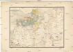
Etnographische Karte des St. Petersburgischen Gouvernements
1 : 1300000 Petrohrad-oblast (Rusko) Koeppen, P. von K. Akademie der Wissenschaften zu St. Peterburg
St. Petersburg, Tichwin
1 : 750000 Petrohrad (Rusko) K. u. k. Militärgeographisches Institut
Ladožskoje ozero i Finskij zalip s prilěžaščimi městami
Finský záliv Seutter, Matthäus Matthaeus Seutter
Ladožskīe kanaly
Russland Russland (Nord) Ladoga-Kanal Schifffahrtskanal Il'in', N.
Tichvinskīj kanal
Russland Russland (Nord) Schifffahrtskanal Il'in', N.
<Karta mesta zanimaemago Sanktpeterburgom : v tom vide v kakom onoe nakhodilos za god do osnovanii͡a goroda; sostavlena dli͡a panoramy S. Peterburga, 1834>
s.n.
Tečenjije Něpy rěki iz Ladolskago ozera k St. Peterburgu
Ladožské jezero (Rusko) Seutter, Matthäus Matthaeus Seutter
Kanaly Višerskīj i Siversov
Russland Russland (Nord) Schifffahrtskanal Il'in', N.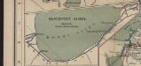
Bělozerskīj kanal
Russland Russland (Nord) Schifffahrtskanal Il'in', N.
Nova et accuratißima Urbis S.t PETERSBURG a Rußorum Imperatore Petro Alwexiewiz A.o 1703 ad ostium Nevae Fl. conditae et regionis circumjacentis Delineatio
1 : 20000 Petrohrad (Rusko) Seutter, Matthäus per Matth. Seutter
Kanal Princa Aleksandra Virtembergskago
Russland Russland (Nord) Schifffahrtskanal Il'in', N.
<Plan Sanktpeterburga v t͡sarstovanie imperatrit͡sy Elisavety Petrovny, 1753>
s.n.
Ladožskoj kanal
1 : 142000 Rusko Seutter, Matthäus Matthaeus Seutter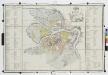
Planʺ stolichnago goroda St. Peterburga = Plan de la ville capitale S. Petersbourg / gr. Al. Savinkov.
From Russia
Nevskaja del'ta
Russland Newa Geografie
<Plan goroda Moskvy, s prigorodami
1 : 21000 Tipografīi͡a A.S. Suvorina Tipograf??ia? A.S. Suvorina
<St. Petersburg = Sanktpeterburga>
1 : 31000 Clarke, W. B Edward Stanford
Plan der Haupt- und Residenzstadt Sct. Petersburg
Petrohrad (Rusko)
<Plan stolichnago goroda Sanktpeterburga : Plan de la ville capitale de St. Petersbourg
1 : 21000 Savinkov, A A. Savinkov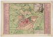
Novoĭ plan stolichnago goroda i kri͡eposti Sanktpeterburga originalnoĭ chertezh sego plana nakhoditsi͡a v arkhivi͡e glavnoĭ Polit͡sīi = Nouveau plan de la ville et de la forteresse de St. Pétersbourg, exécuté exactement d'après l'original qui se trouve dans les Archives de la Police
1 : 20000 Roth, C. M. (Christoph Melchior), 1720-1798 C.M. Roth