Maps of Smolensk

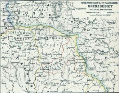
Moskowisch-Litthauisches Grenzgebiet
1 : 6000000 Polen-Litauen, Moskauer Reich, Grenze
Tableau des opérations de la Grande Armée depuis le 8 Aout jusqu'au 20 8bre 1812 (marche de Smolensk à Moscou)
1 : 2300000 Et.ne Henry del. et sculpt.
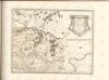
Moscovia
1 : 4500000 1 Karte : Kupferdruck ; 12 x 17 cm Hondius, Jodocus [Verlag nicht ermittelbar]
Moscovia
1 : 4500000 1 Karte : Kupferdruck ; 12 x 17 cm Mercator, Gerhard printed by William Stansby for Henrie Fetherstone
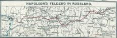
Napoleon's Feldzug in Russland
1 : 7500000 Russland / Europäischer Teil Russlandfeldzug <1812>
Charte von Russisch Litauen
1 : 1320000 Bělorusko auf Kosten der Homännischen Erben
Charte von Russisch Litauen
1 : 1320000 Bělorusko auf Kosten der Homännischen Erben
Charte von Russisch Litauen
1 : 1320000 Bělorusko auf Kosten der Homännischen Erben
Schema dviženīja russkoj rati s 20 avgusta po 7 sentjabrja 1380 g.
Russland Kulikovo Pole Kulikowo Pole / Schlacht Dmitri, Moskau, Großfürst
Li palatinati di Minsk, Mscislaw, Polok, e Witebsk nella Littuania / tratta dall'atlante polacco del
1 : 1400000 1 Karte : Kupferdruck ; 40 x 30 cm Zuliani, Giuliano presso Antonio Zatta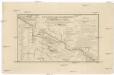
Karta napravlenija železnoj dorogi šossei i vodjanych soobščenij meždu S. Peterburgom i Moskvoju
1 : 1300000 Moskva-oblast (Rusko) Al'tman, I. Flerov, V. v Zavedenii kongrevskoj chromotipii F. Tuma
Połock, Witebsk, Smolensk
1 : 750000 Polack (Bělorusko) K. u. k. Militärgeographisches Institut
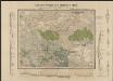
Übersichtskarte von Mittel - Europa

Strategische Übersichts-Karte des polnisch-litaurischen Armee-Bewegungraumes

Dviženīe 1j i 2j armīi k Smolensku.
Russland Smolensk Russlandfeldzug <1812>
Die ältesten russischen Eisenhütten und -hämmer im Moskauer Gebiet
Moskau (Region) Eisenhüttenwerk
Übersichtskarte von Mittel - Europa
Obščaja geologičeskaja karta evropejskoj Rossii : List 57: Moskva, Korceva, Jurʹev, Borovsk, Egorʹevsk
1 : 420000 sostavilʹ S. Nikitin = Carte géologique générale de la Russie d'Europe : Feuille 57: Moscou, Kortschewa, Iouriév, Borovsk, Iégoriévsk dressée par S. Nikitin [S.l.] : [s.n.]
Übersichtskarte von Mittel - Europa

Kijew, Žitomir, Owrucz, Czernobyl, Mozyr, Łojew
1 : 750000 Kyjev (Ukrajina : oblast) Korb, L. K. u. k. Militärgeographisches Institut
Bobrujsk, Czerikow, Str. Szkłow
1 : 750000 Bobrujsk (Bělorusko) Dornhofer, J. K. u. k. Militärgeographisches Institut
Bobrujsk, Czerikow, Str. Szkłow
1 : 750000 Bobrujsk (Bělorusko) K. k. militär-geographisches Institut
Kijew, Žitomir, Owrucz, Czernobyl, Mozyr, Łoiew
1 : 750000 Kyjev (Ukrajina : oblast) K. k. militär-geographisches Institut
Nowgorod, Str. Russa, Ostaszkow
1 : 750000 Novgorod (Rusko) K. u. k. Militärgeographisches Institut
Zdzienciol, Gorodischtsche, Derewna, Ljachowitschi
1 : 100000 Bělorusko
Moskau und Umgegend
1 : 5000000 Moskau
Operacīja Petra Velikago protiv Levengaupta.
Europa