Maps of Vitebsk District

Übersichtskarte von Mittel - Europa

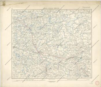
Połock, Witebsk, Smolensk
1 : 750000 Polack (Bělorusko) K. u. k. Militärgeographisches Institut
Dviženīe 1j i 2j armīi k Smolensku.
Russland Smolensk Russlandfeldzug <1812>
Plan dījstvīj pred Lubinskim sraženīem
Russland Smolensk Russlandfeldzug <1812>
Plan‘‘sraženija pri Krasnom‘‘, 5 nojabrja
Russland Krasnoj Russlandfeldzug <1812>
Plan sraženīja pri Smolensk, 5 avgusta.
Russland Smolensk Russlandfeldzug <1812>
Rußland 1:50 000
1 : 50000 Bělorusko OKH
Rußland 1:50 000
1 : 50000 Rusko západní OKH
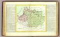
Li palatinati di Minsk, Mscislaw, Polok, e Witebsk nella Littuania / tratta dall'atlante polacco del
1 : 1400000 1 Karte : Kupferdruck ; 40 x 30 cm Zuliani, Giuliano presso Antonio Zatta

Operacīja Petra Velikago protiv Levengaupta.
Europa
Rußland 1:100 000
1 : 100000 Rusko západní OKH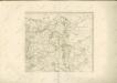

Charte von Russisch Litauen
1 : 1320000 Bělorusko auf Kosten der Homännischen Erben
Charte von Russisch Litauen
1 : 1320000 Bělorusko auf Kosten der Homännischen Erben
Charte von Russisch Litauen
1 : 1320000 Bělorusko auf Kosten der Homännischen Erben
Moskowisch-Litthauisches Grenzgebiet
1 : 6000000 Polen-Litauen, Moskauer Reich, Grenze
Lithvania
1 Karte : Kupferdruck ; 36 x 42 cm Mercator s.n.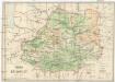
Mapa Bělorusi
1 : 2000000 Bělorusko Orsa, A. Karski, Jauchim
Wschodnia granica Rzeczypospolitej Polskiej ustalona przez Traktat Pokojowy z Ros. Soc. Feder. Republiką Rad i Ukraińską Soc. Republiką Rad, podpisany d. 18. marca 1921 r. w Rydze
Polen Ukraine Sowjetunion Grenze
Wschodnia granica Rzeczypospolitej Polskiej ustalona przez preliminarja pokojowe z Ros. Soc. Feder. Republiką Rad i Ukraińską Soc. Republiką Rad, podpisane d. 12 października 1920 r. w Rydze
Polen Ukraine Sowjetunion Grenze
Im Stillstand von Deulino 1618 an Polen abgetretene Gebiete
1 : 8250000 Moskauer Reich Polnisch-Russischer Krieg <1609-1618>, Gebietsverlust
Karte der Nationalitätengebiete auf dem Territorium des Grossfürstentums Litauen
Litauen Großfürstentum Litauen ethnische Gruppe Świechowski, Marian von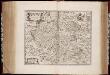
Rvssiæ, vulgo Moscovia dictæ, pars occidentalis / auctore Isaaco Maßa
1 : 2000000 Annotatie: Kaart is vervaardigd omstreeks 1638, en gepubliceerd in de Atlas Maior in 1662; Met wapen; Origineel is Blad 138 in atlas factice; Annotatie geografische gegevens: Met 2 schaalstokken Isaac Abrahamszoon Massa 1586-1643 [Amsterdam : apud Johan. et Cornelium Blaeu]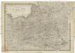
Königreich Pohlen sam[m]t den angränzenden Provinzen
1 : 2060000 Bělorusko Müller, Andreas bey Johann Schönberg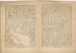
Kriegs Atlas 36 Karten von den Schauplätzen des Weltkrieges 1914/1915
Prusse, Lithuanie.
1 : 3200000 Clouet, J. B. L. (Jean-Baptiste Louis), b. 1730
Feuille 19 (E III), uit: Carte géologique internationale de l'Europe : la carte, votée au congrès géologique international de Bologne en 1881, est exécutée conformément aux décisions d'une commission internationale, avec le concours des gouvernements, sous le dir. de M.M. Beyrich et Hauchecorne
Annotatie: Blad 48 gamme des couleurs; blad 49: bladwijzer en titelblad Heinrich Ernst Beyrich 1815-1896; Wi. Hauchecorne Berlin : Reimer / (Berlin: Institut lithographique)
Magni Ducatus Lithuaniae, Caeterarumque Regionum Illi Adiacentium Exacta Descriptio [Karte], in: Le théâtre du monde, ou, Nouvel atlas contenant les chartes et descriptions de tous les païs de la terre, Bd. 1, S. 82.
1 Karte aus Atlas Blaeu, Willem Janszoon und Blaeu, Joan Blaeu, Willem Janszoon