Maps of Smolensk
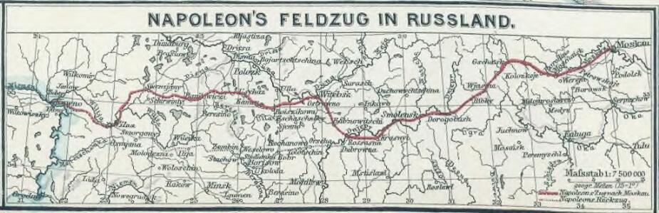
Napoleon's Feldzug in Russland
1 : 7500000 Russland / Europäischer Teil Russlandfeldzug <1812>

Wiłkomierz, Dwinsk (Dünaburg), Wilna, Wilejka, Słonim, Mińsk
1 : 300000 Minsk (Bělorusko : oblast)
Übersichtskarte von Mittel - Europa

Raspoloženīe vojska 1. ījulja.
Litauen Weißrussland Russlandfeldzug <1812>
Karta di’jstvij ot‘‘ Bereziny k‘‘ Vil’ně
Litauen Vilnius Russlandfeldzug <1812>
Dviženīe 1j i 2j armīi k Smolensku.
Russland Smolensk Russlandfeldzug <1812>
Trigonometrisk grunnlag, vedlegg 65, 6-9: Grunnlagspunkter for Struves meridianbue fra Vilnius, Hrodna og Kurland
1 : 200000 de Tenner
Übersichtskarte von Mittel - Europa

Raspoloženīe 1 i 2 armīi pered vojnoju.
Litauen Weißrussland Napoleonische Kriege
Połock, Witebsk, Smolensk
1 : 750000 Polack (Bělorusko) K. u. k. Militärgeographisches Institut
Paasche's Frontenkarte, Nr.10. Der Krieg gegen Russland

[Lietuvos žemelapis]
Litva
Die ältesten russischen Eisenhütten und -hämmer im Moskauer Gebiet
Moskau (Region) Eisenhüttenwerk
Operacīja Petra Velikago protiv Levengaupta.
Europa
Dwinsk (Dünaburg), Friedrichstadt
1 : 750000 Dokšycy (Bělorusko) K. u. k. Militärgeographisches Institut
[Vilnius a okolí]
1 : 38000 Vilnius-oblast (Litva) Frolov
Poland, Western Russia, Latvia and Lithuania [A map of]
This is sheet 322 of a series of maps was prepared for the German Army, and its numeration continues that of the Karte des Deutschen Reiches. Grossblatt 308-441A. [A map of Poland, western Russia, Latvia, and Lithuania, drawn in extension of the Karte des Deutschen Reiches 1:100,000 published by the Reichsamt für Landesaufnahme.]. Germany. Heer. Abteilung für Kriegskarten- und Vermessungswesen. [S.l.] : Hergestellt im Auftrage Gen St d H Abt f Kr Kart u Verm Wes (II)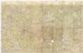
Rußland 1:50 000
1 : 50000 Bělorusko OKH
Okrestnosti g. Tuly i verchnee tečenīe r. Upy
Russland Zentralrussland Tula Umland
Plan mi''stopoloženija meždu Borisovym i Zembinom
Russland Borisov Russlandfeldzug <1812>
Plan‘‘ sraženija pri Tarutině
Ukraine Tarutino Russlandfeldzug <1812>
Die Beresina
1 : 500000 Beresina-Gebiet Schlacht an der Beresina
<Plan goroda Moskvy, s prigorodami
1 : 21000 Tipografīi͡a A.S. Suvorina Tipograf??ia? A.S. Suvorina
Plan dījstvīj pred Lubinskim sraženīem
Russland Smolensk Russlandfeldzug <1812>
[Kowno]
1 : 300000 Kaunas Belagerung, Weltkrieg <1914-1918>
<Moscow = Moskvi>
1 : 33000 Clarke, W. B Publishd under the superintendence of the Society for the Diffusion of Useful Knowledge [by] Charles Knight & Co.
Plan Imperatorskago Stoličnago goroda Moskvy, sočinennoj pod smotreniem architektora Ivana Mičurina v 1739 godu
Moskau Mičurin, Ivan
Plan‘‘sraženija pri Krasnom‘‘, 5 nojabrja
Russland Krasnoj Russlandfeldzug <1812>