Maps of Belarus

Charte von Russisch Litauen
1 : 1320000 Bělorusko auf Kosten der Homännischen Erben
Charte von Russisch Litauen
1 : 1320000 Bělorusko auf Kosten der Homännischen Erben
Charte von Russisch Litauen
1 : 1320000 Bělorusko auf Kosten der Homännischen Erben
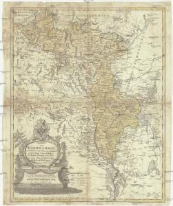
Magnus ducatus Lithuania in suos Palatinatus et Castellanias divisa non solum accuratisime delineata, sed etiam plurimis in alliis Mappis omissis locis
1 : 1350000 Georg Friderich Lotter, sculps. Aug. Vind. : Tob. Conr. Lotter
IV, uit: General-Karte von Mittel-Europa in 12 Blättern, im Masse 1:1.200.000 / entworfen, bearb. und hrsg. von Josef Schlacher
1 : 1200000 Annotatie: Blad 6 ontbreekt; Annotatie geografische gegevens: 21 maatstokken op blad 9; Legenda op blad 9 Wien : K.K. Militär Geografisches Institut

Li palatinati di Minsk, Mscislaw, Polok, e Witebsk nella Littuania / tratta dall'atlante polacco del
1 : 1400000 1 Karte : Kupferdruck ; 40 x 30 cm Zuliani, Giuliano presso Antonio Zatta
Magnus ducatus Lithuania
1 : 149000 Bělorusko Lotter, Tobias Conrad Lotter, Georg F. Tob. Conr. Lotter
Magnus ducatus Lithuania
1 : 149000 Bělorusko Lotter, Tobias Conrad Lotter, Georg F. Tob. Conr. Lotter
Delineatio memorabilis conflictus et victoriae Lithuanorum Duce Radivilio de Cricevio
Bělorusko
Castra defensiva Ducis Radiuly Reciciae, obiecta aduentui Eliae Bohaczenlio
Bělorusko
Strategische Übersichts-Karte des polnisch-litaurischen Armee-Bewegungraumes

Kijew, Žitomir, Owrucz, Czernobyl, Mozyr, Łojew
1 : 750000 Kyjev (Ukrajina : oblast) Korb, L. K. u. k. Militärgeographisches Institut
Bobrujsk, Czerikow, Str. Szkłow
1 : 750000 Bobrujsk (Bělorusko) Dornhofer, J. K. u. k. Militärgeographisches Institut
Bobrujsk, Czerikow, Str. Szkłow
1 : 750000 Bobrujsk (Bělorusko) K. k. militär-geographisches Institut
Kijew, Žitomir, Owrucz, Czernobyl, Mozyr, Łoiew
1 : 750000 Kyjev (Ukrajina : oblast) K. k. militär-geographisches Institut

Raspoloženīe vojska 1. ījulja.
Litauen Weißrussland Russlandfeldzug <1812>

Übersichtskarte von Mittel - Europa

Übersichtskarte von Mittel - Europa

Übersichtskarte von Mittel - Europa

Połock, Witebsk, Smolensk
1 : 750000 Polack (Bělorusko) K. u. k. Militärgeographisches Institut
Dviženīe 1j i 2j armīi k Smolensku.
Russland Smolensk Russlandfeldzug <1812>
Wiłkomierz, Dwinsk (Dünaburg), Wilna, Wilejka, Słonim, Mińsk
1 : 300000 Minsk (Bělorusko : oblast)
Zdzienciol, Gorodischtsche, Derewna, Ljachowitschi
1 : 100000 Bělorusko
Wilna, Minsk, Grodno, Słonim
1 : 750000 Grodno (Bělorusko : oblast) Jakupec, M. K. u. k. Militärgeographisches Institut
Wilna, Minsk, Grodno, Słonim
1 : 750000 Grodno (Bělorusko : oblast) K. k. militär-geographisches Institut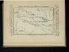
Karta di’jstvij ot‘‘ Bereziny k‘‘ Vil’ně
Litauen Vilnius Russlandfeldzug <1812>