Maps of Homyel'

Kijew, Žitomir, Owrucz, Czernobyl, Mozyr, Łojew
1 : 750000 Kyjev (Ukrajina : oblast) Korb, L. K. u. k. Militärgeographisches Institut
Bobrujsk, Czerikow, Str. Szkłow
1 : 750000 Bobrujsk (Bělorusko) Dornhofer, J. K. u. k. Militärgeographisches Institut
Bobrujsk, Czerikow, Str. Szkłow
1 : 750000 Bobrujsk (Bělorusko) K. k. militär-geographisches Institut
Kijew, Žitomir, Owrucz, Czernobyl, Mozyr, Łoiew
1 : 750000 Kyjev (Ukrajina : oblast) K. k. militär-geographisches Institut
Übersichtskarte von Mittel - Europa

Zdzienciol, Gorodischtsche, Derewna, Ljachowitschi
1 : 100000 Bělorusko
Speciální mapa západního Ruska

Speciální mapa západního Ruska

Boj pri d. Lěsnoj 28 sentjabrja 1708 g.
Weißrussland Lesnaya Nordischer Krieg <1700-1721>
Österreich-Ungarns letzter Krieg
1 : 750000 Dunaj-delta (Rumunsko a Ukrajina) Verlag der Militärwissenschaftlichen Mitteilungen
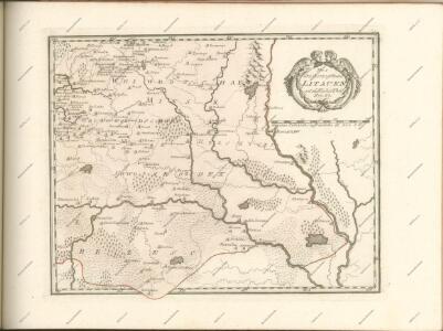
Charte von Russisch Litauen
1 : 1320000 Bělorusko auf Kosten der Homännischen Erben
Charte von Russisch Litauen
1 : 1320000 Bělorusko auf Kosten der Homännischen Erben
Charte von Russisch Litauen
1 : 1320000 Bělorusko auf Kosten der Homännischen Erben
Li palatinati di Minsk, Mscislaw, Polok, e Witebsk nella Littuania / tratta dall'atlante polacco del
1 : 1400000 1 Karte : Kupferdruck ; 40 x 30 cm Zuliani, Giuliano presso Antonio Zatta
Geologičeskaja karta Polěs'ja
1 : 1250000 Polesí
Gipsometričeskaja karta Polěs'ja s oboznačenijem kanalizacii
1 : 1250000 Polesí
Delineatio memorabilis conflictus et victoriae Lithuanorum Duce Radivilio de Cricevio
Bělorusko
Castra defensiva Ducis Radiuly Reciciae, obiecta aduentui Eliae Bohaczenlio
Bělorusko
Strategische Übersichts-Karte des polnisch-litaurischen Armee-Bewegungraumes

Théatre de la guerre actuelle, en Allemagne, en Pologne et en Turquie. n5, Brody
1 : 900000 Chanlaire, Pierre Grégoire 1758-1817 Paris : chez l'auteur P. G. Chanlaire
Li palatinati di Nowogrodek Podlachia e Brzesk Littew / tratta dall'atlante polacco del Sig.r Rizzi
1 : 1300000 1 Karte : Kupferdruck ; 31 x 40 cm Zuliani, Giuliano presso Antonio Zatta
Wilna, Minsk, Grodno, Słonim
1 : 750000 Grodno (Bělorusko : oblast) Jakupec, M. K. u. k. Militärgeographisches Institut
Wilna, Minsk, Grodno, Słonim
1 : 750000 Grodno (Bělorusko : oblast) K. k. militär-geographisches Institut
Übersichtskarte von Mittel - Europa

Karta Černigovskoj gubernii
1 : 840000 Černigov-oblast (Ukrajina) Kartogr. zav. A. Il'jina
Raspoloženīe vojska 1. ījulja.
Litauen Weißrussland Russlandfeldzug <1812>
Übersichtskarte von Mittel - Europa

Übersichtskarte von Mittel - Europa