Maps of Tver
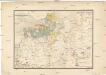
Moscovia
1 : 4500000 1 Karte : Kupferdruck ; 12 x 17 cm Hondius, Jodocus [Verlag nicht ermittelbar]
Moscovia
1 : 4500000 1 Karte : Kupferdruck ; 12 x 17 cm Mercator, Gerhard printed by William Stansby for Henrie Fetherstone
RVSSIÆ, | Vulgo MOSCOVIA dictæ, | Pars Occidentalis
Auctore Isaaco Maßa. [Amsterdam : Joan Blaeu]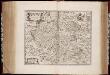
Rvssiæ, vulgo Moscovia dictæ, pars occidentalis / auctore Isaaco Maßa
1 : 2000000 Annotatie: Kaart is vervaardigd omstreeks 1638, en gepubliceerd in de Atlas Maior in 1662; Met wapen; Origineel is Blad 138 in atlas factice; Annotatie geografische gegevens: Met 2 schaalstokken Isaac Abrahamszoon Massa 1586-1643 [Amsterdam : apud Johan. et Cornelium Blaeu]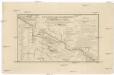
Karta napravlenija železnoj dorogi šossei i vodjanych soobščenij meždu S. Peterburgom i Moskvoju
1 : 1300000 Moskva-oblast (Rusko) Al'tman, I. Flerov, V. v Zavedenii kongrevskoj chromotipii F. Tuma
Russia 4.
1 : 1900800 Letts, Son & Co.
Russia Part lV.
1 : 1770000 Society for the Diffusion of Useful Knowledge (Great Britain)
Übersichtskarte von Mittel - Europa
Etnographische Karte des St. Petersburgischen Gouvernements
1 : 1300000 Petrohrad-oblast (Rusko) Koeppen, P. von K. Akademie der Wissenschaften zu St. Peterburg
Nowgorod, Str. Russa, Ostaszkow
1 : 750000 Novgorod (Rusko) K. u. k. Militärgeographisches Institut
Połock, Witebsk, Smolensk
1 : 750000 Polack (Bělorusko) K. u. k. Militärgeographisches Institut
Province de St. Petersbourg
1 : 840000 [St. Petersbourg] : [A. Iljin]
General'naja Karta Sanktpeterburgskoj Gubernii
1 : 1125000 composé et gravée par Piadicheff les leteres grav. M. Iwanoff St. Petersbourg, [s.n.]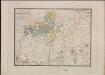
Ethnographische Karte des St. Petersburgischen Gouvernements
Gouvernement Sankt Petersburg Ethnische Gruppe, Bevölkerung Keppen, Petr I.
Übersichtskarte von Mittel - Europa

Der Kampf um Petrograd (Oktober 1919)
Russland (Nordwest) Russischer Bürgerkrieg <1917-1921>
Der Kampf um Petrograd (August 1919)
Russland (Nordwest) Russischer Bürgerkrieg <1917-1921>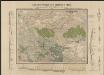
Obščaja geologičeskaja karta evropejskoj Rossii : List 57: Moskva, Korceva, Jurʹev, Borovsk, Egorʹevsk
1 : 420000 sostavilʹ S. Nikitin = Carte géologique générale de la Russie d'Europe : Feuille 57: Moscou, Kortschewa, Iouriév, Borovsk, Iégoriévsk dressée par S. Nikitin [S.l.] : [s.n.]
INGRIA.
[Amsterdam : Joan Blaeu]
Die ältesten russischen Eisenhütten und -hämmer im Moskauer Gebiet
Moskau (Region) Eisenhüttenwerk
Moskau und Umgegend
1 : 5000000 Moskau
Rußland 1:100 000
1 : 100000 Rusko západní OKH
Rußland 1:50 000
1 : 50000 Rusko západní OKH
Tichvinskīj kanal
Russland Russland (Nord) Schifffahrtskanal Il'in', N.
Rußland 1:50 000
1 : 50000 Bělorusko OKH
Kanaly Višerskīj i Siversov
Russland Russland (Nord) Schifffahrtskanal Il'in', N.
Rußland 1:100 000
1 : 100000 Rusko západní OKH
Plan‘‘ sraženija pri Tarutině
Ukraine Tarutino Russlandfeldzug <1812>
Rußland 1:50 000
1 : 50000 Rusko západní OKH/Gen St d H