Maps of Moskovsskaya

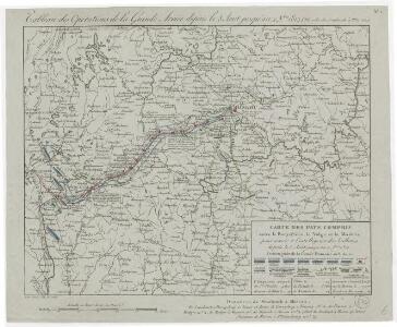
Tableau des opérations de la Grande Armée depuis le 8 Aout jusqu'au 20 8bre 1812 (marche de Smolensk à Moscou)
1 : 2300000 Et.ne Henry del. et sculpt.
Im Stillstand von Deulino 1618 an Polen abgetretene Gebiete
1 : 8250000 Moskauer Reich Polnisch-Russischer Krieg <1609-1618>, Gebietsverlust
Moskowisch-Litthauisches Grenzgebiet
1 : 6000000 Polen-Litauen, Moskauer Reich, Grenze
Partie, Russie d'Europe. Europe 10.
1 : 1641836 Vandermaelen, Philippe, 1795-1869
Schema dviženīja russkoj rati s 20 avgusta po 7 sentjabrja 1380 g.
Russland Kulikovo Pole Kulikowo Pole / Schlacht Dmitri, Moskau, Großfürst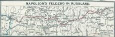
Napoleon's Feldzug in Russland
1 : 7500000 Russland / Europäischer Teil Russlandfeldzug <1812>
Połock, Witebsk, Smolensk
1 : 750000 Polack (Bělorusko) K. u. k. Militärgeographisches Institut
Obščaja geologičeskaja karta evropejskoj Rossii : List 57: Moskva, Korceva, Jurʹev, Borovsk, Egorʹevsk
1 : 420000 sostavilʹ S. Nikitin = Carte géologique générale de la Russie d'Europe : Feuille 57: Moscou, Kortschewa, Iouriév, Borovsk, Iégoriévsk dressée par S. Nikitin [S.l.] : [s.n.]
Dviženīe 1j i 2j armīi k Smolensku.
Russland Smolensk Russlandfeldzug <1812>
Übersichtskarte von Mittel - Europa

Die ältesten russischen Eisenhütten und -hämmer im Moskauer Gebiet
Moskau (Region) Eisenhüttenwerk
Schema ovražistosti južnoj časti Okskago bassejna v predělach Rjazanskoj gub.
Russland Oka
Strategische Übersichts-Karte des polnisch-litaurischen Armee-Bewegungraumes

Übersichtskarte von Mittel - Europa

Übersichtskarte von Mittel - Europa

Nowgorod, Str. Russa, Ostaszkow
1 : 750000 Novgorod (Rusko) K. u. k. Militärgeographisches Institut
Moskau und Umgegend
1 : 5000000 Moskau
Operacīja Petra Velikago protiv Levengaupta.
Europa
Okrestnosti g. Rjazani i bližajšaja k nej čast' tečenīja r. Oki
Russland Zentralrussland Rjasan Oka
Okrestnosti g. Orla i verchov'ja r. Oki
Russland Zentralrussland Orel Oka
Okrestnosti g. Tuly i verchnee tečenīe r. Upy
Russland Zentralrussland Tula Umland
Verchov'ja r.r. Dona i Šata
Russland Zentralrussland Don Umland
Plan‘‘ sraženija pri Tarutině
Ukraine Tarutino Russlandfeldzug <1812>
Terrainskizze des kulikow'schen Feldes
Kulikowo Pole Kulikowo Pole / Schlacht
Aus dem Jegorjewer Kreis des Gouv. Rjasan
Russland Gouvernement Rjasan Deutsche
Kulikovskaja bitva 8go sentjabrja 1380 g.
Russland Kulikovo Pole Kulikowo Pole / Schlacht Dmitri, Moskau, Großfürst
<Plan goroda Moskvy, s prigorodami
1 : 21000 Tipografīi͡a A.S. Suvorina Tipograf??ia? A.S. Suvorina
Plan dījstvīj pred Lubinskim sraženīem
Russland Smolensk Russlandfeldzug <1812>
<Moscow = Moskvi>
1 : 33000 Clarke, W. B Publishd under the superintendence of the Society for the Diffusion of Useful Knowledge [by] Charles Knight & Co.